

Tornado Watches Issued
A few things to note from the graphic:
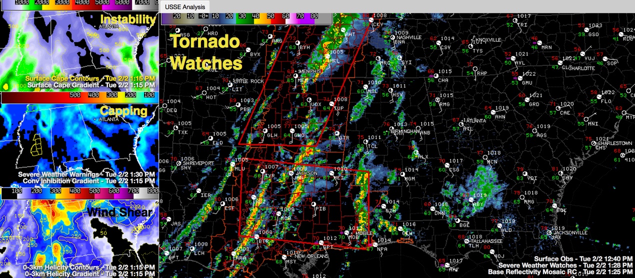
…A tornado watch has now been issued for northern Mississippi, western Tennessee, western Kentucky and small parts of eastern Arkansas, southern Illinois and the Missouri Bootheel. It goes until 7 p.m.
…A new tornado watch has also been issued for parts of southeastern Louisiana, southern Mississippi, southwestern Alabama and the extreme NW Florida Panhandle. It includes New Orleans Biloxi, Mobile, Greenville, Evergreen, Monroeville, Atmore and Pensacola. It will go until 7 p.m. as well.
…The airmass across eastern Arkansas, eastern Louisiana, southwestern Mississippi and southeastern Louisiana has been moderately unstable, with CAPE values between 1000-2000 j/kg. The temperature and dewpoint is 70/68F at Jackson and 71F/67F at Meridian at this hour.
…There is still some capping across much of Alabama and northeastern Mississippi. That is eroding quickly. Storms will be able to form after that.
…Strong storms have formed over Central Mississippi. There is a severe thunderstorm warning west of Philadelphia.
…With some sun, temperatures have become quite warm over Central Alabama. It is now 75F/60F at the Birmingham Airport and 76F/65F at Tuscaloosa.
Category: Alabama's Weather, Severe Weather
About the Author (Author Profile)
Bill Murray is the President of The Weather Factory. He is the site's official weather historian and a weekend forecaster. He also anchors the site's severe weather coverage. Bill Murray is the proud holder of National Weather Association Digital Seal #0001 @wxhistorianSubscribe
If you enjoyed this article, subscribe to receive more just like it.


