

7 p.m. Update for Alabama
Click image to enlarge.
Things have calmed considerably this evening across Alabama and the Southeast.
The only warning in Alabama right now is a severe thunderstorm warning for Lawrence County, and only four severe thunderstorm warnings are in effect across the Southeast. There are two severe thunderstorm warnings are in effect for Mississippi and one for Tennessee.
A tornado watch continues for much of North and central Alabama until 10 p.m. A new tornado watch has been issued for parts of Central and southern Mississippi and Southwest Alabama.
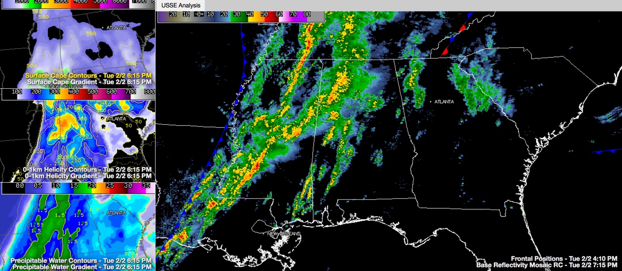
RADAR UPDATE
A long line of showers and storms extends from southern Tennessee through northwestern Alabama into Central and southern Mississippi. The area of rain and storms is merging into a thin squall line that is just ahead of the cold front. It will become a wide line of showers and storms that will cross the states of Mississippi and Alabama overnight.
There is a good bit of lightning and thunder in the activity over West and Northwest Alabama.
Scattered showers and storms are over southern Mississippi and southwestern Alabama. This activity will continue to move to the northeast and will merge into the larger rain mass with time.
INSTABILITY ON THE WANE
CAPE Values have dropped below 500 joules/kg across all of Alabama except for Sumter and Choctaw Counties. So there is little fuel for the storms, but there is a good bit of wind shear, so we will have to continue to respect any storms that do get going. 0-1 km helicity values are off the charts, running 300-500 m2/s2 across much of Alabama.
REMAINING THREAT
The main threat for the rest of the night should be damaging winds.
TIMING
The main line of rain and storms will hang around in the same areas through 11 p.m. before it starts to move. It should extend from Tuscaloosa to Cullman around 2 a.m. It should be in the Birmingham area between 3 and 4 p.m.
That front is over western Mississippi right now. Dewpoints drop sharply behind it. At Greenville MS, the dewpoint dropped from 66F at 4 p.m. to 49F this hour. It should be through Pell City and Talladega by 4 a.m. and then through Anniston by 5 a.m.
HEAVY RAIN THREAT
High moisture content air is still being pulled into the system over Mississippi and western Alabama. One hour rainfall rates with the heavier storms will be over one inch. Flash flood and flood warnings cover a good bit of Central parts of North Mississippi.
Category: Alabama's Weather, Severe Weather
About the Author (Author Profile)
Bill Murray is the President of The Weather Factory. He is the site's official weather historian and a weekend forecaster. He also anchors the site's severe weather coverage. Bill Murray is the proud holder of National Weather Association Digital Seal #0001 @wxhistorianSubscribe
If you enjoyed this article, subscribe to receive more just like it.


