

Cold Today, Warmer Sunday, Wet Monday
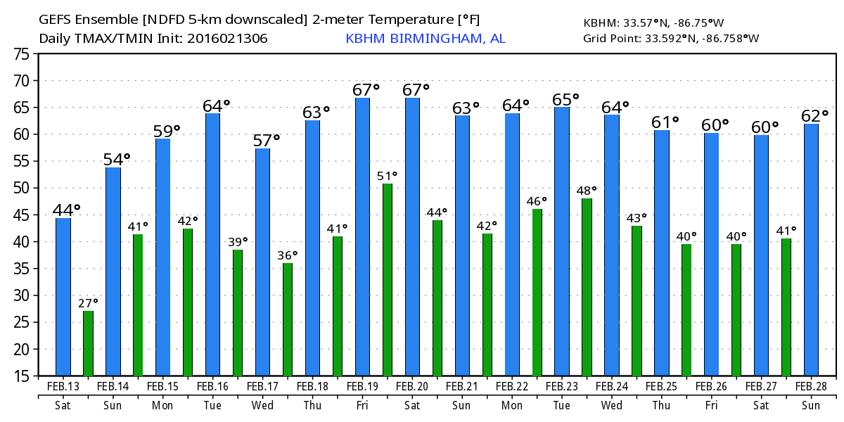
The expected weather for Central Alabama runs the gamut from cold to wet over the next several days. Alabama is waking up to a clear sky with temperatures in the vicinity of freezing while the Tennessee River Valley counties are in the 20s. A surface high was centered Minnesota and Iowa while aloft we have yet another fairly deep trough over the eastern US with ridging along the Rockies. This pattern was allowing bitterly cold air to invade the northern portions of the US from the Dakotas to New England with lots of single digit temperature readings. The watch/warning map included a band of winter weather advisories from the Dakotas southeastward to Central Illinois. Wind chill advisories and warnings covered much of the Great Lakes area, all of New England, and much of Ohio, Pennsylvania, Maryland, Virginia and West Virginia.
The upper air pattern will change fairly quickly as the upper trough moves quickly out into the Atlantic and the upper flow flattens over the Southeast US. This will allow us to warm up nicely for Sunday as temperatures climb nicely into the 50s after a very brisk morning with lows well down in the 20s. Clouds will return Sunday with the sky expected to become cloudy by late afternoon and evening. Then the wet weather arrives.
A fast moving upper trough will move from the Missouri/Kansas border on Monday into the Atlantic by Tuesday. This will bring a weak surface low from northern Louisiana to the Mid-Atlantic states on Tuesday. This opens the way for some thunderstorms on Day 3, Monday, mainly along the Central Gulf Coast from Southeast Louisiana to the western Florida Peninsula. SPC has this area outlooked with a marginal risk for severe storms. Given that the main dynamics are further north and the warm sector won’t have much time to develop, the threat for severe weather should be low, but not zero. Temperatures will recover nicely despite the clouds and rain with highs Monday in the middle to upper 50s.
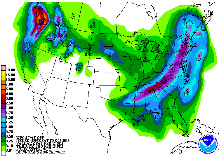
A stronger trough come into the western Great Lakes area on Tuesday with a strong surface low over Illinois. This sets up yet another snow storm for the Northeast US for Wednesday, but with moisture very limited, the from coming through the Southeast should be dry. Tuesday should be a fairly warm day for Central Alabama with highs around the 60-degree mark. That dry front is going to knock temperatures back again for Wednesday but only a little with highs in the middle 50s.
Ridging aloft becomes the main story for our weather pattern for Thursday and Friday. Another trough that remains well to our north on Friday and Saturday will bring another cold front into the area on Saturday. At least for now, it looks like only small chances for some showers on Saturday with highs in the lower 60s.
Looking out into voodoo country, a strong trough dives into the eastern US on Tuesday and Wednesday, dropping out temperatures back again. Ridging will again moderate our temperatures before another trough dives through the Great Lakes toward the Mid-Atlantic States by the 28th of February.
Thanks for tuning into the Alabama Weather Xtreme Video. I plan to have the next edition posted here by 8 am or so on Sunday. I’m looking forward to some meet-and-greet time today as ABC 3340 participates in the World of Wheels at the BJCC. If you plan to be there, be sure to look up our booth. Enjoy your day and stay warm. Godspeed.
-Brian-
Category: Alabama's Weather
About the Author (Author Profile)
Brian Peters is one of the television meteorologists at ABC3340 in Birmingham and a retired NWS Warning Coordination Meteorologist. He handles the weekend Weather Xtreme Videos and forecast discussion and is the Webmaster for the popular WeatherBrains podcast.Subscribe
If you enjoyed this article, subscribe to receive more just like it.


