

Talk Turns from Wintry to Severe Weather
Funny how we have gone from talking about the threat of a wintry mix early Monday to the threat of severe weather for Monday afternoon and evening across the state.
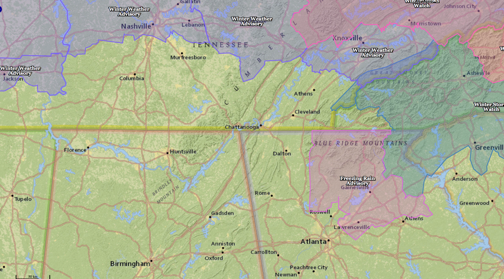
WINTER WEATHER UPDATE
A wintry mix will affect parts of Middle and eastern Tennessee overnight tonight. Places like Clarksville, Nashville and Murfreesboro may see a mix of light rain, sleet and snow, changing over to rain during the night.
A winter weather advisory covers much of northern Middle and Eastern Tennessee. Winter storm watches are in effect for the Smokies back through much of northern North Carolina. Two inches of snow should fall in Gatlinburg.
Winter storm warnings are in effect for Northeast Tennessee and northern North Carolina. Johnson City TN is expecting 3-7 inches of snow.
A mix of rain, freezing rain and snow will impact areas around Knoxville with light snow down into the Smoky Mountains.
A mix of sleet and freezing rain will affect northeastern Georgia overnight, from Roswell to Lawrenceville back to Gainesville and Athens. A freezing rain advisory is in effect.
Greenville SC, Asheville, Charlotte and Greensboro NC are in a winter storm watch for a mix of sleet and freezing rain that will continue for much of the morning on Monday.
Alabama should be free of any wintry weather problems.
SEVERE WEATHER UPDATE
Low pressure at the surface is centered near Dallas this afternoon with a snake warm front extending to the east, lifting northward across Arkansas and western Mississippi. This surface low will progress slowly eastward overnight tonight, and showers will spread into Northwest Alabama this evening ahead of that warm front.
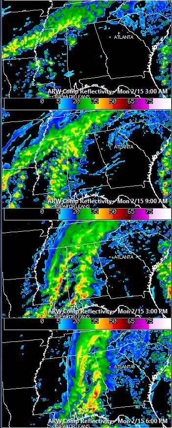
By Monday morning, the surface low will be near Memphis. Alabama will be solidly in the warm sector by then, and showers and some thunder will increase during the early morning hours. Periods of showers and storms will continue throughout the day.
It will become breezy on Monday, with southerly winds averaging 8-16 mph. It won’t feel very humid, as dewpoints will only be able to manage to rise into the lower 50s. High temperatures will be in the upper 50s.
The airmass will destabilize sufficiently across Southwest Alabama for a threat of severe weather on Monday afternoon and evening. The SPC has a slight risk of severe weather (their basic severe weather forecast category) over that part of the state, including places like Mobile, Butler, Greenville, Evergreen and Brewton.
In the slight risk area, damaging winds and an isolated tornado or two is possible. Elsewhere, there is a low threat of damaging winds.
A marginal risk, extends as far north as Tuscaloosa, Clanton and Eufaula. Place like Hamilton, Cullman, Gadsden, Jasper, Birmingham, Anniston, Calera, Talladega, Alex City and Auburn should see just showers and storms.
Thunder will be heard across the entire area tomorrow and showers and storms increase during the morning and continue into the afternoon. A line of storms will sweep across the state from west to east during the late afternoon and evening.
The storms should reach Tuscaloosa by late afternoon, Birmingham during the early evening and Anniston by mid-evening. Overnight lowers will be in the upper 30s to lower 40s.
Category: Alabama's Weather, Winter Weather
About the Author (Author Profile)
Bill Murray is the President of The Weather Factory. He is the site's official weather historian and a weekend forecaster. He also anchors the site's severe weather coverage. Bill Murray is the proud holder of National Weather Association Digital Seal #0001 @wxhistorianSubscribe
If you enjoyed this article, subscribe to receive more just like it.


