

From Record Heat to Snow Chances: You Gotta Love Alabama Weather
As James said this morning, “this is a month where anything goes” and there couldn’t be a much truer statement.
A major shift in the pattern is taking us from the record warmth of the past three weeks to chances of some wintry precipitation this weekend.
In between, as one might expect, there is a chance of severe weather tonight with a slight risk on the SPC outlook down into Northwest Alabama with a marginal risk down to to a line from Reform to Birmingham to Ragland and Piedmont.
The line of storms will move through during the pre-dawn hours, so have a way to receive warnings overnight in case severe thunderstorm warnings are required. The biggest threat is damaging winds. The possibility of hail or a tornado is very small and limited to the Northwest Corner of the state.
The big news is the change to colder. A cold front will pass through the area tomorrow morning, in the wake of the line of storms. But the main surge of cold air will arrive Saturday night. Highs on Sunday will have a hard time to get out of the 40s during the day on Sunday.
We expect a cold rain across Central Alabama Saturday night that could change over to snow over North Alabama.
Here is the 12km NAM model depiction of snowfall amounts for North Alabama by Sunday morning.
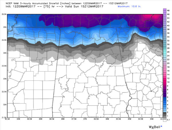
NAM model snowfall accumulation forecast for early Sunday morning.
Warm ground temperatures will work against significant accumulations, which is good news.
So while this is NOT a forecast, but does indicate the real possibility of accumulating snow over North Alabama late Saturday night. Something to be aware of and monitor.
A widespread freeze looks likely for Tuesday night and highs on Wednesday will have a hard time getting out of the 40s Wednesday as well.
Category: Alabama's Weather, ALL POSTS
About the Author (Author Profile)
Bill Murray is the President of The Weather Factory. He is the site's official weather historian and a weekend forecaster. He also anchors the site's severe weather coverage. Bill Murray is the proud holder of National Weather Association Digital Seal #0001 @wxhistorianSubscribe
If you enjoyed this article, subscribe to receive more just like it.


