


The weather across Central Alabama is going to settle down for the weekend with good weather into the first of next week, too. See clouds may linger across South Alabama today, but North and Central Alabama should see plenty of sunshine and lower humidity as the drier air gets a good grip on the Southeast US. Look for the highs today and Sunday to be in the 60s, a little below our seasonal average of 71. The morning low Sunday will be around 40, a bit chillier than we’ve seen in several days.
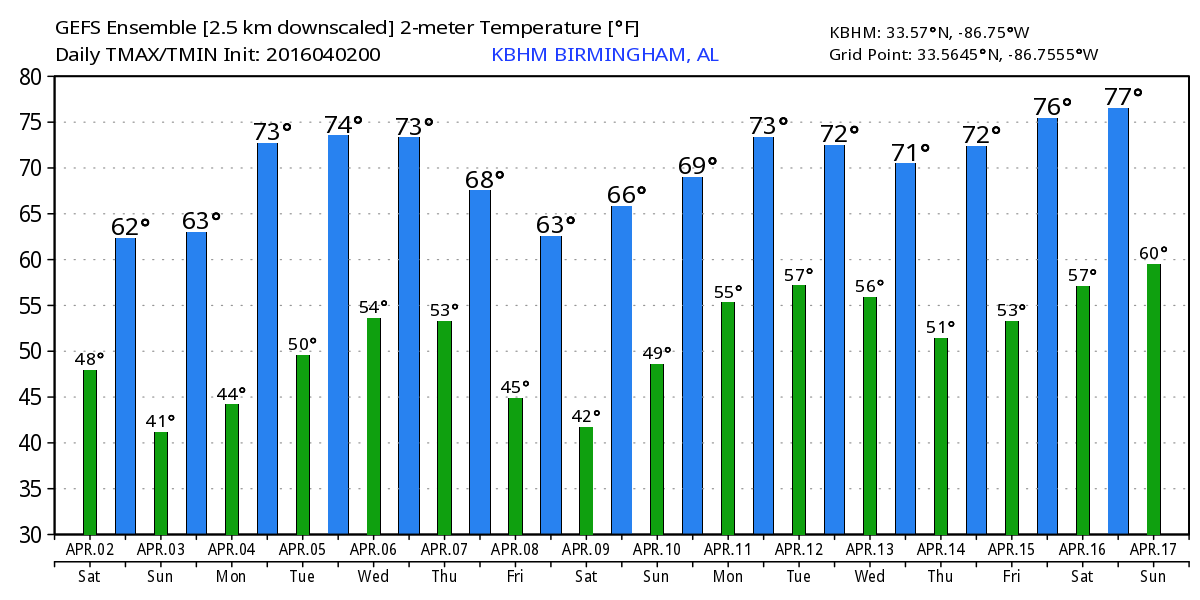
For those with plans for the beach, rain has finally exited the Gulf Coast and very little rain is expected in the next week with the exception of a few showers late Wednesday night and early Thursday morning. Highs will be in the 70s. Lows will be in the 40s and 50s. The water temperature was running right around 70F.
The upper trough is forecast to bottom out later today and move off the East Coast on Sunday. This will keep out weather dry Sunday. A short wave trough will move through the Great Lakes area on Monday dragging a weak front into the Tennessee River Valley. Without much moisture to work with, the front will make its presence known with a few passing clouds. The high Monday should be near 70.
Tuesday and Wednesday will be dry for us with an upper ridge in place. Look for highs to stay around 70, pretty close to the 30-year averages. But a fast moving trough coming through the Middle Mississippi River Valley Wednesday afternoon promises a chance at showers Wednesday evening and into early Thursday. I’m not expecting much rainfall with this system, and based on the current positions projected for the trough and frontal system, it looks like we probably will not see any threat for severe weather.
But we will be turning colder once again by Friday and into next Saturday as a fairly deep trough moves by us on Friday and into Saturday with the surface high settling right over the Southeast US. Temperatures will once again drop into the lower 60s for highs with the potential for lows in the 30s by Saturday morning. With the prospects of the surface high positioned right over Alabama and Mississippi on next Saturday, we have to be concerned for the possibility of a late frost. MOS guidance is printing out a low of 37 for Birmingham next Saturday morning, and with the surface high overhead, we could see a good radiational cooling situation with patchy frost and some of those typically colder, sheltered areas dipping to the freezing mark. As we’ve seen already this year, it would not take much wind to keep the air stirred up, so we’ll keep an eye on this possibility with future runs.
Looking into Week 2, or voodoo country, the GFS shows a fairly strong short wave trough bringing us thunderstorms late on the 11th and into the 12th. But by the 14th, a strong ridge bulges up into Southeast Canada promising some very warm weather for the eastern half of the country around the 15th. That big ridge is beaten down by a trough moving across southern Canada on the 17th of April.
I expect to have the next Weather Xtreme Video posted here by 8 am or so on Sunday morning. Have a great day and enjoy the change to drier and cooler weather for the weekend. Godspeed.
-Brian-


