


WINDY, COOL SPRING DAY: Temperatures are only in the low 60s across North/Central Alabama this afternoon despite sunshine in full force; a gusty northwest wind of 15-25 mph is making it feel cooler.
Tonight will be clear and chilly with diminishing wind; most places will see a low around 40 degrees early tomorrow; Northeast Alabama will drop into the 30s with some risk of scattered frost.
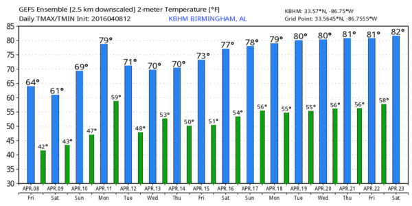
THE ALABAMA WEEKEND: Sunny weather continues tomorrow, and we stay cool. The high will be close to 60, and most places north of Birmingham won’t get out of the 50s. Expect another cold morning Sunday; Northeast Alabama drops into the 30s again, and some of the colder spots could very well see a freeze. Best chance of frost at daybreak Sunday will be generally north of a line from Florence to Cullman to Anniston to Roanoke. Counties like Lauderdale, Limestone, Madison, Jackson, Cullman, DeKalb, Cherokee, Etowah, Calhoun, Cleburne, and Randolph.
We will amend the forecast to mention the risk of a little scattered light rain Sunday as a warm front pushes northward; moisture will be very limited, but you might encounter a few raindrops during the middle of the day. Sunday’s high will be in the upper 60s with intervals of sunshine.
NEXT WEEK: Monday looks dry and mild with a high between 72 and 75 degrees, then we will deal with a round of showers and thunderstorms Monday night into Tuesday. The overall severe weather threat for now looks pretty low, and rain amounts of 1/2 to 3/4″ are likely. Then, by Wednesday, the best chance of rain shifts down into far South Alabama. Thursday and Friday will be mostly sunny and mild with a high in the 70s. See the Weather Xtreme video for maps, graphics, and more details.
AT THE BEACH: Dry and pleasant weather continues on the Gulf Coast from Panama City Beach over to Gulf Shores through Monday; showers and storms return Tuesday and Wednesday. Highs mostly in the 70s… See a very detailed Gulf Coast forecast here.
STORM SPOTTER TRAINING IS TOMORROW: Storm Spotter Xtreme is tomorrow at the BJCC from 9am to 2pm. This will feature both the basic and advanced SKYWARN classes, along with a session from Kevin Laws of the Birmingham NWS office. And, if you come, you get free admission to the Alabama International Auto Show, going on at the BJCC that same day. There is no cost and no need to register. Just show up with a curious mind. Kids 10 and older will also enjoy this if they love weather and want to learn more.
The entrance for everyone attending is the East Exhibition Hall entrance, go left and enter the doors marked North Meeting rooms C-I adjacent to the bathrooms before you get to the escalators on the right wall. Please help us make the severe weather warning process better!
WEATHER BRAINS: Don’t forget you can listen to our weekly 90 minute netcast anytime on the web, or on iTunes. This is the show all about weather featuring many familiar voices, including our meteorologists here at ABC 33/40.
CONNECT: You can find me on all of the major social networks…
Facebook
Twitter
Google Plus
Instagram
I enjoyed seeing the kindergarten students today at Paine Primary School in Trussville… and a big Classical Conversations home school group at Brookview Church in Irondale… be looking for them on the Pepsi KIDCAM today at 5:00 and 6:00 on ABC 33/40 News! My next Weather Xtreme video will be posted Monday morning by 7:00… Brian Peters will have the video updates tomorrow and Sunday. Enjoy the weekend!


