

Dry Pattern For Alabama; TD 9 Stays East
RADAR CHECK: You can pretty much count the number of showers on radar this afternoon on one hand. They are small, short lived, and moving to the west…
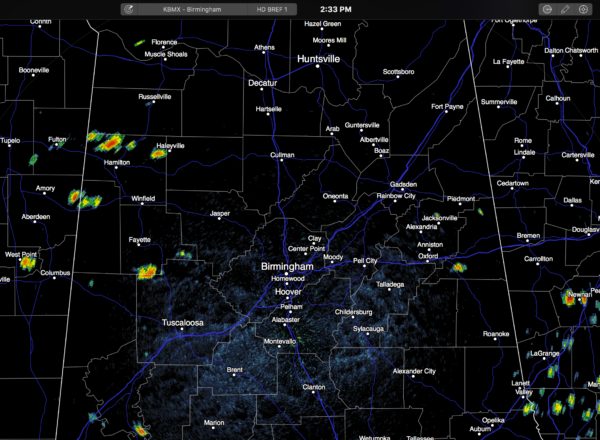
Away from the showers, the sky is partly to mostly sunny with temperatures in the 91-95 degree range.
The weather won’t change much tomorrow and Wednesday; lots of sun both days with only isolated afternoon showers or thunderstorms, along with highs in the low to mid 90s.
THURSDAY/FRIDAY: The ridge breaks down, and we should see a shot of drier, continental air by Thursday night and Friday. A few widely scattered showers or storms is possible Thursday afternoon and evening, but Friday looks rain-free as the dry air takes over. The humidity will be lower Friday, and conditions will be much more comfortable for high school football games Friday night. Not really cooler, but at least the humidity will be down.
LABOR DAY WEEKEND: For Alabama we project mostly sunny days and fair nights Saturday through Monday. Highs 88-91, lows in the 60s. Some of the cooler spots across North Alabama could reach the upper 50s early Saturday morning.
And, the dry pattern looks to hold into the middle part of next week. See the Weather Xtreme video for maps, graphics, and more details.
FOOTBALL WEATHER: First off, Friday night looks fantastic for high school football across Alabama with a clear sky and temperatures falling through the 70s. Humidity levels won’t be as bad as the first two weeks.
Auburn hosts Clemson Saturday night at Jordan-Hare Stadium (8:00p CT kickoff)… the sky will be clear. Kickoff temperature near 78 degrees, falling into the low 70s by the final whistle.
Alabama will take on Southern Cal Saturday night at Arlington, Texas (8:00p CT kickoff)… a clear sky with temperatures falling from near 82 at kickoff, into the mid 70s by the end of the game.
TROPICS: Hurricane Gaston remains well organized in the Atlantic east of Bermuda, but it is moving eastward away from the U.S.
We note a well organized tropical wave is about to emerge off the coast of Africa; this has a good chance of developing over the Atlantic as it moves westward late this week and over the weekend. WAY too early to know if this recurves over the open water, or tries to make a run at the Greater Antilles or the U.S. Just something to watch.
Tropical Depression Eight remains very disorganized, but still some chance it becomes a minimal tropical storm in coming days. It will recurve just off the Outer Banks of North Carolina, and head back out to sea. The main impact will be rough surf, but this will be long gone by the Labor Day weekend.
Tropical Depression Nine in the Southeast Gulf of Mexico is also very disorganized. Still a chance it becomes a tropical storm over the next 48 hours…. it will turn eastward, with the broad center moving into North Florida Thursday. Then, it continues moving moving out over the open Atlantic, and it will be long gone by the Labor Day weekend as well (at least as far as the Southeast U.S. is concerned).
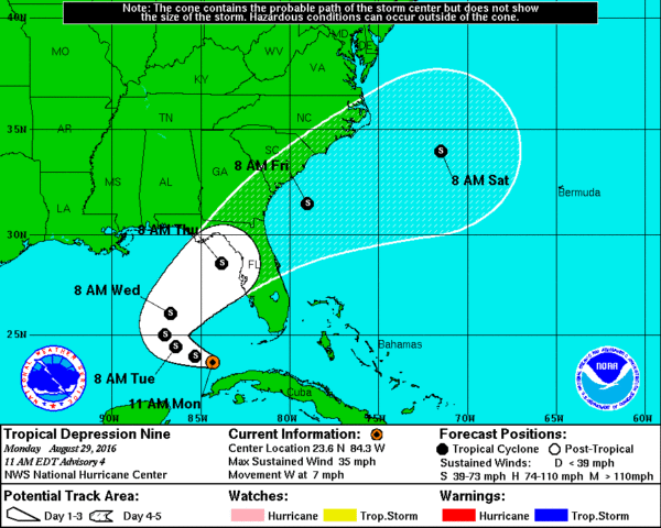
*TD 9 will have no direct impact on Alabama, although it will help to pull down drier air late this week.
*The main issue with the system is rain for the Florida Peninsula (not the panhandle), and dangerous surf/rip tides. Most of the rain over the Florida Peninsula will fall today through Thursday. The rain won’t be continuous, however, and the sun will be out at times.
*TD 9 will be well off in the Atlantic by the Labor Day weekend; nothing but the routine risk of “widely scattered thunderstorms” for Florida with a good supply of sunshine by then. Even for places like Orlando, Tampa, and Daytona Beach.
GULF COAST WEATHER: Generally speaking, the weather looks fine on the Central Gulf Coast (Gulf Shores east to Panama City Beach) this weekend, and over the holiday weekend with 7 to 9 hours of sunshine daily and only widely scattered showers. The exception will be at Panama City Beach Thursday as TD 9 passes just to the south… periods of rain are likely on that one day. And, also keep in mind there will be potential for rip tides along the coast this week, especially tomorrow, Wednesday, and Thursday. But, the surf will settle down for the weekend. Highs on the immediate coast will be in the upper 80s, with low 90s inland. See a very detailed Gulf Coast forecast here.
WEATHER BRAINS: Don’t forget you can listen to our weekly 90 minute netcast anytime on the web, or on iTunes. This is the show all about weather featuring many familiar voices, including our meteorologists here at ABC 33/40. We will produce this week’s show tonight at 8:30 CT… you can watch it live here.
CONNECT: You can find me on all of the major social networks…
Facebook
Twitter
Google Plus
Instagram
Look for the next Weather Xtreme video here by 7:00 a.m. tomorrow…
Category: Alabama's Weather
About the Author (Author Profile)
James Spann is one of the most recognized and trusted television meteorologists in the industry. He holds the AMS CCM designation and television seals from the AMS and NWA. He is a past winner of the Broadcast Meteorologist of the Year from both professional organizations.Subscribe
If you enjoyed this article, subscribe to receive more just like it.


