

Hello Hermine; Dry Pattern For Alabama
RADAR CHECK: Showers are almost impossible to find this afternoon… we have a few small, isolated showers and storms over the northern quarter of the state; those will dissipate once the sun goes down this evening.
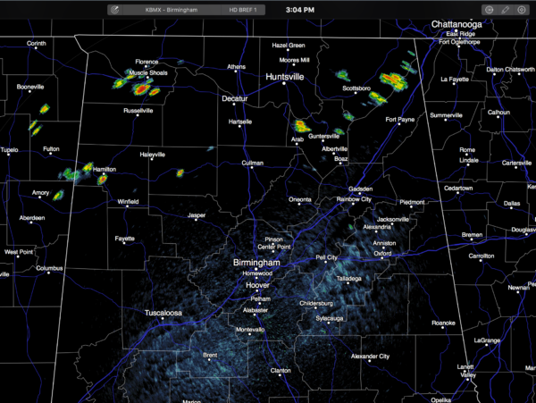
Temperatures are generally in the low to mid 90s on this last day of meteorological summer.
TOMORROW: Not real change; lots of sunshine, a high in the low 90s, and only isolated showers.
FRIDAY AND THE LABOR DAY WEEKEND: An upper trough will be in place over the eastern U.S. Friday.. that, and the circulation on the west side of the tropical system passing us to the east, will help to pull down drier, continental air into Alabama. Friday will be a sunny day with a high in the upper 80s, and lower humidity levels. The weather will stay dry Saturday through Monday with mostly sunny days and fair nights; highs 88-91, and lows in the 60s.
A few isolated afternoon showers could show up by the middle of next week, but we see no widespread rain anytime soon for Alabama. See the Weather Xtreme video for maps, graphics, and more details.
HERMINE IS ON THE BOARD: Tropical Depression Nine, formerly known as “Invest 99L”, was upgraded to Tropical Storm Hermine early this afternoon in the Gulf of Mexico. The circulation center is expected to go into Florida, near Port St. Joe, tomorrow night.
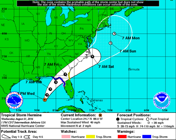
Hermine will not impact most of Alabama in a direct way, although breezy conditions are likely around Dothan tomorrow night along with a few showers.
Here are the important impact points…
*A Hurricane Watch is in effect for Anclote River to Indian Pass Florida. A Tropical Storm Warning is in effect from the Anclote River to the Walton/Bay County line, and a Tropical Storm Watch is in effect for Marineland, Florida to Altamaha Sound, Georgia.
*The main issues with Hermine will come along and east of the center, or from Port St. Joe down to Horseshoe Beach, Cedar Key, and Hernando Beach.
*The combination of a dangerous storm surge and the tide will cause normally dry areas near the coast to be flooded by rising waters moving inland from the shoreline. There is a danger of life-threatening inundation within the next 36 to 48 hours along the Gulf coast of Florida from Aripeka to Indian Pass. Note this does NOT include Panama City Beach, or points to the west; they are on the dry side of the circulation (off shore flow)
*In addition to surge flooding, rains of 5-10 inches are possible east of a line from Marianna to Port St. Joe, and that could produce flash flooding.
*A few tornadoes are possible tomorrow and tomorrow night over North Florida, again east of a line from Marianna to Port St. Joe.
*Very rough surf and dangerous rip tides are likely on the Gulf Coast all the way from Dauphin Island down to Fort Myers Beach from now through Friday morning. The Gulf will calm down by Friday night and the Labor Day weekend.
*Hermine will move up the Atlantic coast Friday and Saturday, bringing wind and rain to places like Savannah, Charleston, and Wilmington. It will cause wet and windy conditions Saturday around the Outer Banks of North Carolina.
*Next week, there is a chance Hermine could actually bend back toward the U.S. East Coast as an upper high builds north of the system.
CENTRAL GULF COAST FORECAST: The weather looks nice today through the holiday weekend for places like Gulf Shores, Pensacola Beach, and Destin; the main wind and rain from Hermine stays east of these coastal communities. Mostly sunny days, fair nights, and only widely scattered showers and storms. For Panama City Beach, the weather will be windy with some rain at times tomorrow and tomorrow night, but Friday through Monday should be very nice with ample sunshine each day and only scattered showers or storms.
But, please keep in mind double red flags are flying at most of these places due to rough surf, and it will be sometime Friday before the Gulf waters begin to subside.
FOOTBALL WEATHER: Friday night looks fantastic for high school football across Alabama with a clear sky and temperatures falling through the 70s. Humidity levels won’t be as bad as the first two weeks.
Auburn hosts Clemson Saturday night at Jordan-Hare Stadium (8:00p CT kickoff)… the sky will be clear. Kickoff temperature near 76 degrees, falling into the low 70s by the final whistle.
Alabama will take on Southern Cal Saturday night at Arlington, Texas (8:00p CT kickoff)… a clear sky with temperatures falling from near 82 at kickoff, into the mid 70s by the end of the game.
WEATHER BRAINS: Don’t forget you can listen to our weekly 90 minute netcast anytime on the web, or on iTunes. This is the show all about weather featuring many familiar voices, including our meteorologists here at ABC 33/40.
CONNECT: You can find me on all of the major social networks…
Facebook
Twitter
Google Plus
Instagram
Look for the next Weather Xtreme video here by 7:00 a.m. tomorrow…
Category: Alabama's Weather
About the Author (Author Profile)
James Spann is one of the most recognized and trusted television meteorologists in the industry. He holds the AMS CCM designation and television seals from the AMS and NWA. He is a past winner of the Broadcast Meteorologist of the Year from both professional organizations.Subscribe
If you enjoyed this article, subscribe to receive more just like it.


