

Eyes On Hurricane Matthew
ALABAMA STAYS DRY: While the weather world is focused on Hurricane Matthew, let’s not forget that much of North/Central Alabama is dealing with very significant drought conditions, and it will only worsen over the next 10-15 days as the pattern remains dry. This is not unusual in that October is our driest month of the year, but we came into the month with very dry conditions. Please be extremely careful with outdoor burning, don’t throw cigarettes out the window while driving, and conserve water.
This will be the 16th consecutive day with no rain at Birmingham (based on data at the airport).
REST OF THE WEEK: Today should be the warmest day of the week with highs this afternoon in the 87 to 91 degree range, but mid to upper 80s are likely tomorrow and Thursday. Nights will remain pleasant, however. Friday’s high will drop into the low 80s.
MUCH COOLER BY SUNDAY: Sunny days and fair nights will continue into the weekend, but the coolest air so far this season will be pulled southward into Alabama Sunday thanks to the circulation on the west side of Hurricane Matthew. The high Saturday will be in the upper 70s, but on Sunday the high will be near 70, and most communities north of Birmingham will hold in the 60s all day with a fresh north breeze. We project lows well down in the 40s early Sunday and Monday morning, and 30s are likely for colder valleys and protected areas. Some chance there could even a a touch of light frost in those places.
FOOTBALL WEATHER: Another delightful night for high school football games Friday night… clear with temperatures falling through the 60s.
Auburn will play at Mississippi State Saturday (11:00a CT kickoff)… the sky will be sunny with temperatures rising from 77 at kickoff, to near 82 degrees by the fourth quarter.
Alabama is also on the road; they play Arkansas at Fayetteville Saturday evening (6:00p CT kickoff)… a perfect evening for football with temperatures falling from 67 at kickoff into the 50s by the fourth quarter. The sky will be clear.
BARBER VINTAGE MOTORCYCLE FESTIVAL: This event runs from this Friday through Sunday at the Barber Motorsports Park. Highs in the low 80s Friday, but cooling into the upper 70s Saturday, and low 70s Sunday. Sunny days, clear nights. The weather could not be better. Get ticket information right here.
NEXT WEEK: Same story; sunny pleasant days, clear cool nights. No rain opportunity showing up through at least Friday October 14. See the Weather Xtreme video for maps, graphics, and details.
AT THE BEACH: Mostly sunny days, fair nights on the coast from Gulf Shores to Panama City Beach through most of next week; highs generally in the 80s. Showers will be very hard to find… See a very detailed Gulf Coast forecast here.
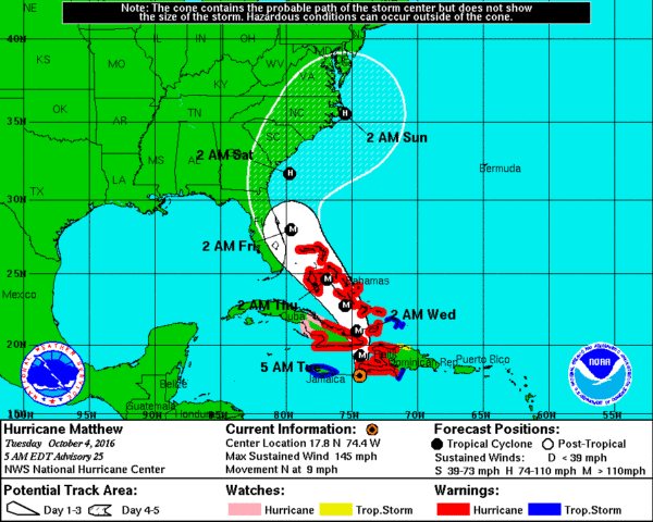
MATTHEW: The eye of extremely dangerous Hurricane Matthew is on the Tiburon Peninsula of Haiti early this morning.
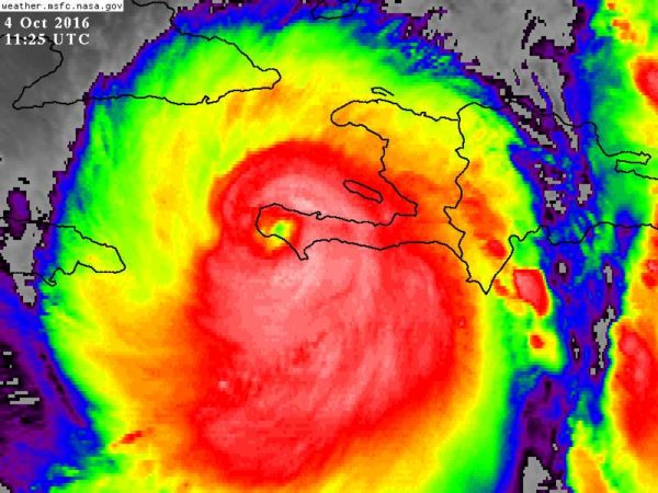
Top winds are 145 mph, and catastrophic damage is likely over Haiti, and a humanitarian crisis is unfolding.
The hurricane will move up through the Bahamas, then sideswiping the Southeast U.S. coast later this week.
Some important notes…
*Alabama will not see a drop of rain from Matthew.
*For those of you planning a trip to Disney World/Orlando, Matthew will pass east of there later this week. The good news is that the heaviest rain will be well east of Orlando, but conditions there will be pretty breezy on Friday with occasional showers. Winds should be in the 20-30 mph range, with potential for higher gusts. The weekend will be beautiful with sunny days and fair nights.
*The U.S. Atlantic coast will remain on the “good” west side of the hurricane, but still there will be lots of wind and rain for cities like Miami, Daytona Beach, Jacksonville, Savannah, and Charleston. Probably not much structural damage, probably no severe flooding, however. Biggest concern will be over the North Carolina Outer Banks Saturday night and Sunday.
*The New England coast/Boston will deal with wind and rain Sunday and Sunday night as the system begins to weaken and accelerate. This could be a huge issue for the Red Sox/Indians playoff game scheduled for Sunday evening at Fenway Park.
*Remember, expect surprises from tropical systems, so things could change. Stay in close touch with the latest updates and forecasts if you are close to the path of Matthew.
WEATHER BRAINS: Don’t forget you can listen to our weekly 90 minute netcast anytime on the web, or on iTunes. This is the show all about weather featuring many familiar voices, including our meteorologists here at ABC 33/40. Scroll down for the show notes on the episode we recorded last night.
CONNECT: You can find me on all of the major social networks…
Facebook
Twitter
Google Plus
Instagram
I have weather programs today at Leeds Primary School, and Cherokee Bend School in Mountain Brook. Look for the next Weather Xtreme video here by 4:00 this afternoon… enjoy the day!
Category: Alabama's Weather
About the Author (Author Profile)
James Spann is one of the most recognized and trusted television meteorologists in the industry. He holds the AMS CCM designation and television seals from the AMS and NWA. He is a past winner of the Broadcast Meteorologist of the Year from both professional organizations.Subscribe
If you enjoyed this article, subscribe to receive more just like it.


