


FIRE DANGER WARNING ISSUED: Due to the ongoing drought, the Alabama Forestry Commission has issued a warning concerning wildfires… this is from their release earlier today…
“Because extremely dry weather conditions and low humidity have combined to create an atmosphere favorable for wildfires, the Alabama Forestry Commission has issued a Fire Danger Warning for 46 Alabama counties effective immediately, until appreciable rainfall is received. These counties include: Autauga, Bibb, Blount, Calhoun, Chambers, Cherokee, Chilton, Clay, Cleburne, Colbert, Coosa, Cullman, Dallas, DeKalb,
Elmore, Etowah, Fayette, Franklin, Greene, Hale, Jackson, Jefferson, Lamar, Lauderdale, Lawrence, Lee,
Limestone, Lowndes, Macon, Madison, Marion, Marshall, Montgomery, Morgan, Perry, Pickens, Randolph, Russell, Shelby, St. Clair, Sumter, Talladega, Tallapoosa, Tuscaloosa, Walker, and Winston.
The Fire Danger Warning was issued because of current drought conditions, continued lack of precipitation, high probability of fuel ignition, and shortage of available manpower and resources. In the last seven days, 142 wildfires have occurred in north Alabama burning approximately 1,500 acres of land. Although the state is not under any type of burning restriction, the Commission is urging everyone to delay outdoor burning until conditions improve if at all possible. While under the fire danger warning, all necessary safety precautions should be exercised when doing any type burning. As always, call the Alabama Forestry Commission for a burn permit.”
Bottom line is that we expect sunny days and fair nights through the weekend with no risk of rain. Highs will be in the 80s through Saturday, cooling down into the mid to upper 70s Sunday and Monday. We do note on the new model runs this morning there is some hope of a cold front bringing a few showers toward the end of next week, but that is only a chance for now, and if it happens rain probably won’t be too heavy or especially beneficial.
Today will be the 17th consecutive day with no measurable rain for Birmingham. FYI… the longest dry streak for the Birmingham area is 52 consecutive days, ending on Nov 20, 1924. That, of course, means there was no rain for the entire month of October in 1924.
FOOTBALL WEATHER: Another delightful night for high school football games Friday night… clear with temperatures falling through the 60s.
Auburn will play at Mississippi State Saturday (11:00a CT kickoff)… the sky will be sunny with temperatures rising from 78 at kickoff, to near 83 degrees by the fourth quarter.
Alabama is also on the road; they play Arkansas at Fayetteville Saturday evening (6:00p CT kickoff)… a perfect evening for football with temperatures falling from 67 at kickoff into the 50s by the fourth quarter. The sky will be clear.
BARBER VINTAGE MOTORCYCLE FESTIVAL: This event runs from this Friday through Sunday at the Barber Motorsports Park. Highs in the mid 80s Friday and Saturday, cooling into the mid to upper 70s Sunday. Sunny days, clear nights. Get ticket information right here.
AT THE BEACH: Sunny days, fair nights, showers almost impossible to find from Panama City Beach over to Gulf Shores through early next week; highs generally in the 80s. See a very detailed Gulf Coast forecast here.
NICOLE: Tropical Storm Nicole should meander about in the Atlantic south of Bermuda for the next five days, and it no threat to land. Top winds are now 50 mph.
MATTHEW: This one is getting all the attention, and for good reason. Maximum sustained winds are 120 mph, and the hurricane is battering the Bahamas this afternoon. It will move to a point very close to the Florida Atlantic coast near Titusville Friday.
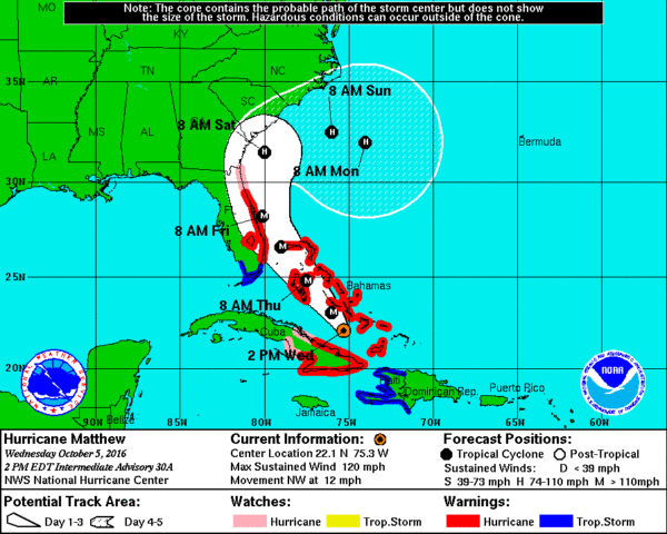
IMPACT: Forecasting impact on the Florida Atlantic coast remains a challenge, but you have to plan for a worst case scenario. Hurricane warnings are up from north of Golden Beach to the Flagler/Volusia county line, with a hurricane watch northward to Jacksonville.
Most of Florida will be on the “good” west side of the circulation; heaviest rain will be offshore on the “bad” east side.
Highest chance of wind damage and flooding will be on the immediate coast. As you work your way westward, the impact will be much lower.
ORLANDO/DISNEY WORLD: No doubt Friday will be windy and wet in Orlando with winds of 20-40 mph, but odds of serious flooding or widespread damage are low there. If you are planning a Disney trip, I would not cancel, and if you are there, I would not end your vacation early. Understand the weather should be very nice there Saturday and Sunday… you just have to deal with the inclement weather on Friday. And even on Friday it certainly won’t rain all day.
DOING THE LOOP? Guidance continues to suggest that there is a decent chance Matthew will turn to the right off the Georgia coast, followed by a loop over the Atlantic east of Florida this weekend and early next week. The 12Z run brings it back into South Florida Monday as a much weaker system. This solution is not carved in stone, but it is plausible.
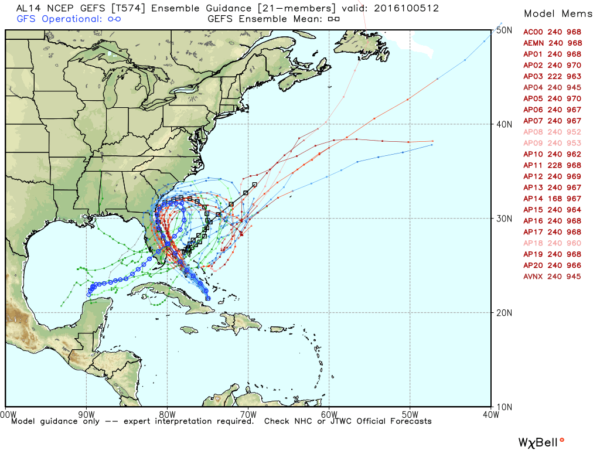
The “loop” solution means very little impact from Matthew north of Charleston, SC, and the upper Atlantic coast is pretty much “off the hook”. But understand forecast skill with a tropical cyclone is very low beyond five days… so this could change.
ALABAMA: Not a drop of rain in Alabama from Matthew, and the “loop” solution means the big cool down Sunday and Monday won’t be as pronounced here.
GULF OF MEXICO: Could Matthew enter the Gulf of Mexico if the “loop” happens? Yes, but it will be much weaker, and it remains to be seen if it happens at all. Just something to watch with this very interesting tropical system.
WEATHER BRAINS: Don’t forget you can listen to our weekly 90 minute netcast anytime on the web, or on iTunes. This is the show all about weather featuring many familiar voices, including our meteorologists here at ABC 33/40.
CONNECT: You can find me on all of the major social networks…
Facebook
Twitter
Google Plus
Instagram
Look for the next Weather Xtreme video here by 7:00 a.m. tomorrow…


