

Drought Conditions Continue
LONG DRY SPELL CONTINUES: Today will be the 25th consecutive day without measurable rain for Birmingham, and prospects for beneficial rain remain pretty much zero through early next week.
Governor Bentley signed a Drought Emergency Declaration yesterday due to extremely dry conditions… the declaration prohibits all outdoor burning in 46 counties in north and central Alabama.
The following counties are affected by the burn ban : Autauga, Bibb, Blount, Calhoun, Chambers, Cherokee, Chilton, Clay, Cleburne, Colbert, Coosa, Cullman, Dallas, DeKalb, Elmore, Etowah, Fayette, Franklin, Greene, Hale, Jackson, Jefferson, Lamar, Lauderdale, Lawrence, Lee, Limestone, Lowndes, Macon, Madison, Marion, Marshall, Montgomery, Morgan, Perry, Pickens, Randolph, Russell, Shelby, St. Clair, Sumter, Talladega, Tallapoosa, Tuscaloosa, Walker, and Winston.
Additionally, the Alabama Forestry Commission (AFC) has issued a Fire Alert for the remaining counties in south Alabama, effective immediately.
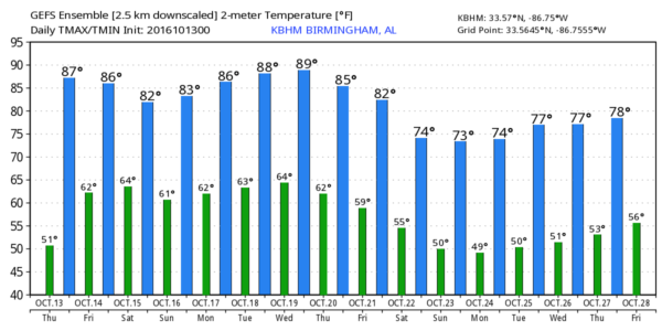
COOL MORNINGS, WARM AFTERNOONS: Vic Bell at Black Creek (just northeast of Gadsden) reports 39 degrees just before sunrise this morning; many places are in the 40s. But, the dry air over Alabama will heat very effectively, and we rise into the mid 80s this afternoon. Some communities will climb 45 degrees from morning low to afternoon high. The sky will remain mostly sunny.
TOMORROW THROUGH THE WEEKEND: A weak surface front near the northwest corner of Alabama means there will be some risk of widely scattered showers over far North Alabama and the Tennessee Valley tomorrow and Saturday, but rain there will be light and spotty, and most of the state remains dry with a partly to mostly sunny sky each day. The high tomorrow will be in the mid 80s, followed by low 80s over the weekend.
FOOTBALL WEATHER: Clear for the high school games tomorrow night with temperatures falling from the mid 70s at kickoff into the upper 60s by the fourth quarter.
Alabama will play at Tennessee in Knoxville Saturday afternoon (2:30p CT kickoff)… expect a cloudy periods with showers possible. About 75 degrees at kickoff, falling to near 70 by the final whistle.
Auburn has the week off.
NEXT WEEK: The latest run of the GFS hints of a cold front nearing the state by Thursday of next week with a decent chance of showers. Not a drought-buster by any means, but maybe some places will at least get the dust settled. We should also note we will approach record warmth over the first half of the week, with upper 80s possible. Cooler air arrives Thursday and Friday. See the Weather Xtreme video for maps, graphics, and more details.
NATIONAL SHRIMP FESTIVAL: One of the biggest events of the year kicks off at Gulf Shores today, and the weather could not be better. Sunny days, fair nights through Sunday with highs in the 80s. See a very detailed Gulf Coast forecast here.
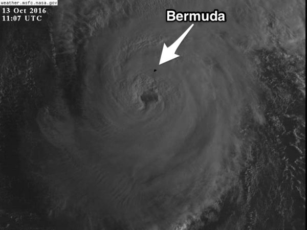
NICOLE HAMMERING BERMUDA: Category four Hurricane Nicole will pass right over the small island of Bermuda this morning; maximum sustained winds are at 130 mph.
WEATHER BRAINS: Don’t forget you can listen to our weekly 90 minute netcast anytime on the web, or on iTunes. This is the show all about weather featuring many familiar voices, including our meteorologists here at ABC 33/40.
CONNECT: You can find me on all of the major social networks…
Facebook
Twitter
Google Plus
Instagram
Look for the next Weather Xtreme video here by 4:00 this afternoon… enjoy the day!
Category: Alabama's Weather
About the Author (Author Profile)
James Spann is one of the most recognized and trusted television meteorologists in the industry. He holds the AMS CCM designation and television seals from the AMS and NWA. He is a past winner of the Broadcast Meteorologist of the Year from both professional organizations.Subscribe
If you enjoyed this article, subscribe to receive more just like it.


