

An Update To Our Weather Situation at 12:30 AM CST
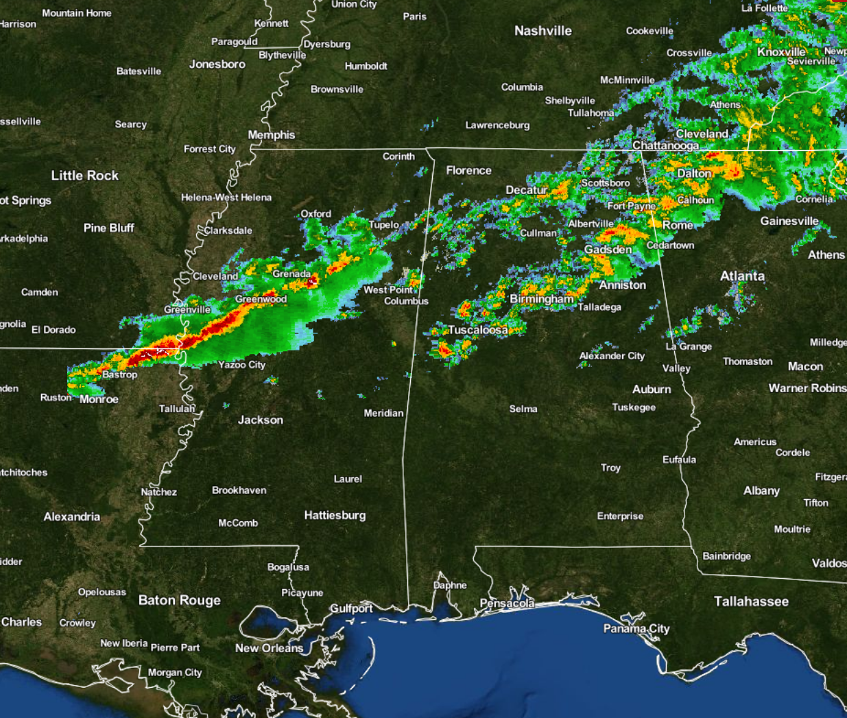
The first line of showers and a few embedded thunderstorms has become broken and may have lost a little strength as it has moved across Central Alabama. Our eyes will now focus back out to our west, as another squall line has developed from north-central Mississippi, back to the west-southwest through the southeastern tip of Arkansas and northern Louisiana. This line has grown and strengthened over the last hour or so, but is still below severe limits. This will be our main threat from strong to severe storms will come from.
The Storm Prediction Center still has almost the entire northern half of Alabama in a “Marginal Risk” for severe storms throughout the remainder of the night and into the morning on Thursday. Damaging straight-line winds and small hail, and a brief spin-up tornado will be the main risks with tonight’s event.
The latest HRRR model run has the higher instability values confined to the southern 2/3rds (which is a little farther north than last update) of the area, with those only reaching 500 J/kg at around 2:00 AM. Helicity (shear) values are now losing the impressive look that they had earlier, but values are still in the 150-250 m2/s2 range. Along with those numbers, dewpoints will be in the low to mid 60s. So the ingredients are still there for marginal strong to severe storms, the question is “Will we get the lift needed for storms to go severe?” That is why there is a squall line ahead of the front, instead of supercells forming in advance.
I believe the timing on this new line will be from 1AM-3AM for the northwestern parts (east of a line from Tuscaloosa to Birmingham to Gadsden), 3AM-5AM for the central and eastern parts (Anniston, Alexander City, Clanton, Selma, and Demopolis), and from 4AM-8AM for the southeastern parts (Montgomery, Troy, Eufaula, and Auburn).
Bill Murray and myself will keep you updated throughout the night and the early morning hour. Remember that we are also on Facebook and on Twitter. Time to fire up the coffee pot!
Category: Alabama's Weather, Severe Weather
About the Author (Author Profile)
Scott Martin is an operational meteorologist, professional graphic artist, musician, husband, and father. Not only is Scott a member of the National Weather Association, but he is also the Central Alabama Chapter of the NWA president. Scott is also the co-founder of Racecast Weather, which provides forecasts for many racing series across the USA. He also supplies forecasts for the BassMaster Elite Series events including the BassMaster Classic.Subscribe
If you enjoyed this article, subscribe to receive more just like it.


