

A Stormy Midday Across Central Alabama
A Stormy Day Across Central Alabama At Midday
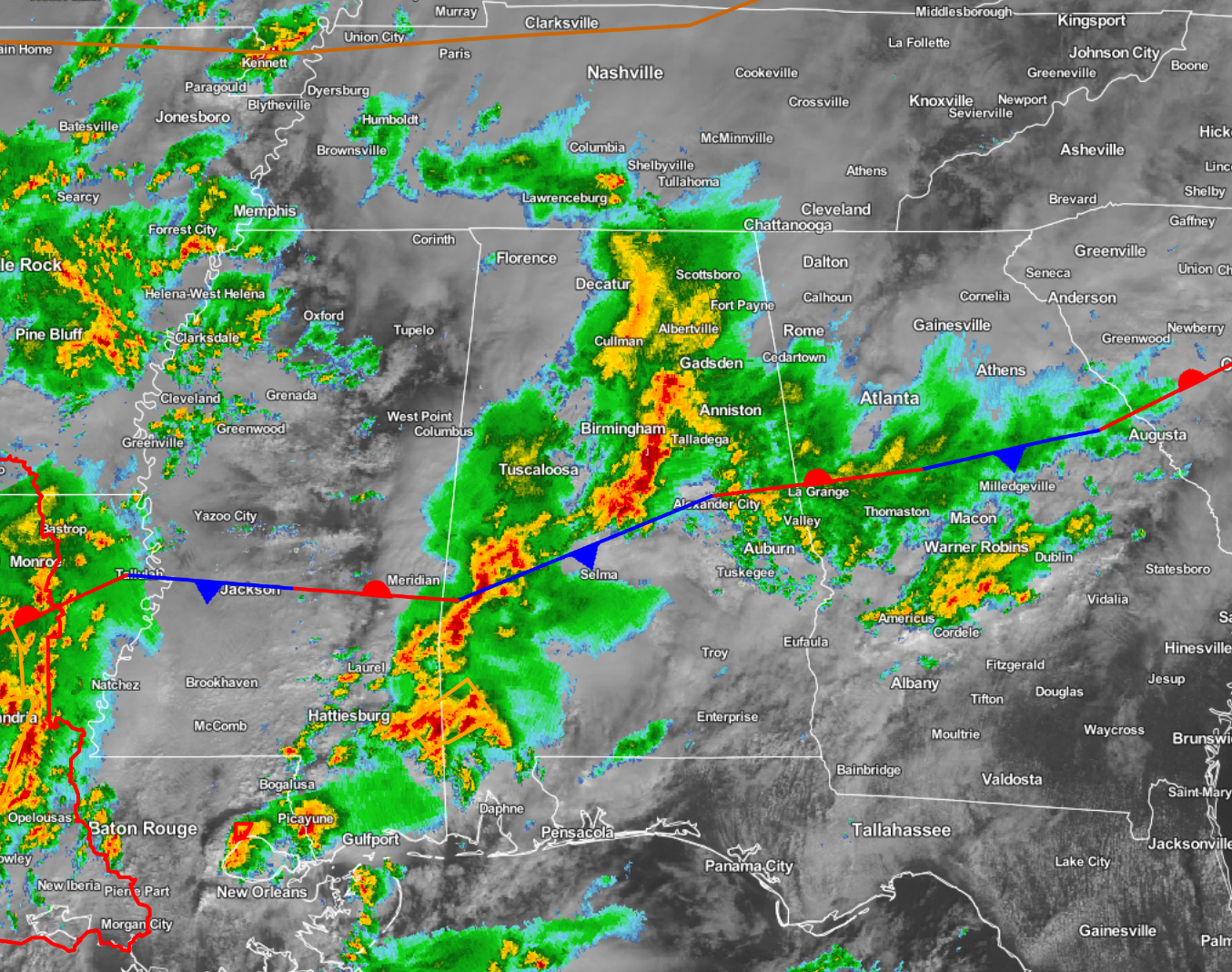
A pretty active day already so far across not only Central Alabama, but across much of the southeastern United States. A tornado watch is in effect across Western Louisiana, parts of Southern Arkansas, and parts of southeastern Texas. Currently, only one tornado warning is in effect for parts of St. Tammany and Tangipahoa parishes in Louisiana, and only three severe thunderstorm warnings across the southeastern states.
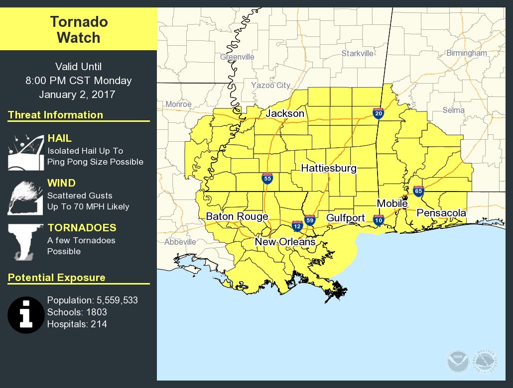
A new tornado watch has been issued until 8:00 PM CST for parts of Southwestern Alabama, Southern Mississippi, and Eastern Louisiana. This watch includes Greene and Sumter Counties.
Across Central Alabama, heavy showers and thunderstorms are currently supplying much of the area with beneficial rainfall, with some of it coming down too fast for the ground to handle. Flash flooding has been reported in parts of Tuscaloosa and Jefferson counties within the last hour or so. Remember, if water covers the roadway and you cannot see the road under the water, please turn around and go a different route.
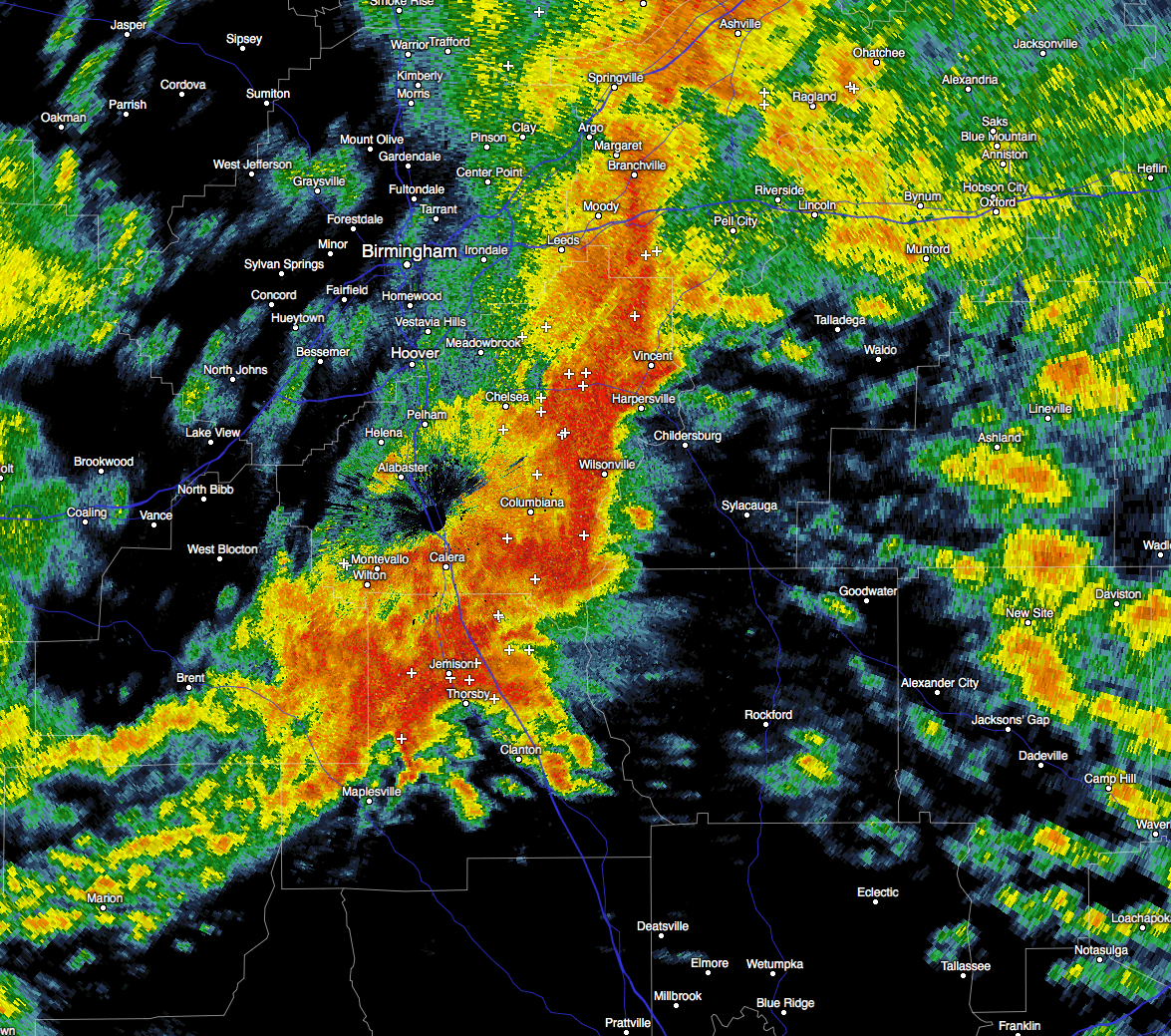
The strongest storms at this point are affecting parts of Clay, St. Clair, Coosa, and Talladega counties. A Significant Weather Advisory has been issued for those locations until 11:45 AM CST.
All of these storms are pushing off to the northeast, but these are only the first round. More thunderstorms are expected to move in later this afternoon, and these will bring the better chance for severe weather across the area.
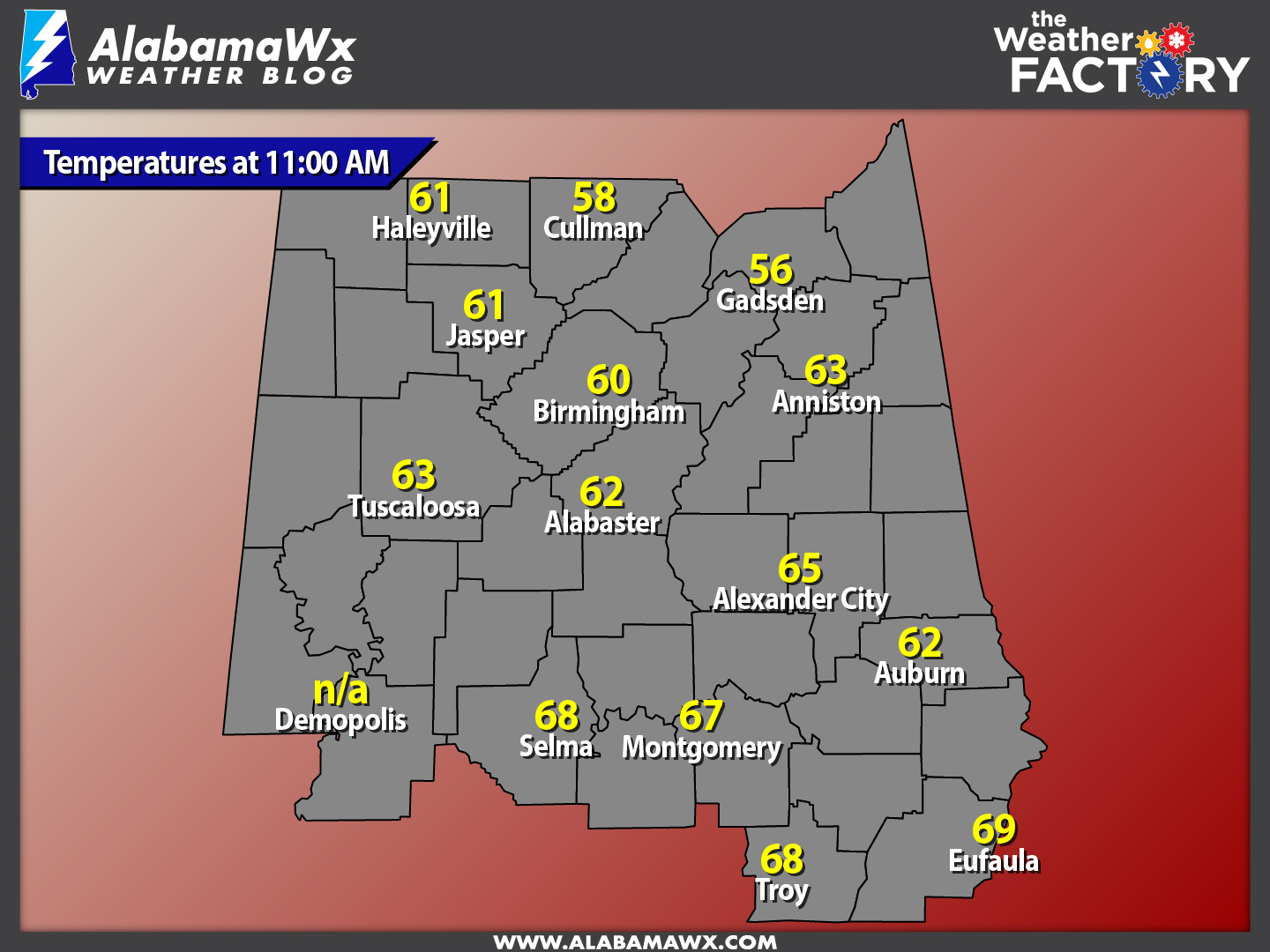
Temperatures Across Central Alabama
Temperatures at 11:00 AM are ranging from the mid 50s in the northern parts of the area, to near 70 degrees in the south. The warm spot is currently Eufaula at 69 degrees. The cool spot is currently Gadsden at 56 degrees.
Birmingham’s Climatology And Records
The normal high for January 2nd is 53, while the normal low is 33. The record high for today was set back in 2006 at 77 degrees. The record low was set back in 1928 at 5 degrees.
Weather For The Remainder Of The Day
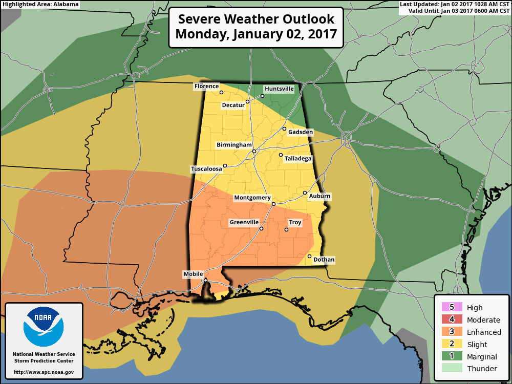
Severe weather will be possible throughout the remainder of the day and into the early morning hours of Tuesday throughout Central Alabama. All of the area is still defined in a “slight risk” for severe weather from now until tomorrow morning, with the extreme southern parts of the area defined in the “enhanced risk” for severe weather. All modes of severe weather will be possible today across the area, but more likely in the enhanced risk areas. Scattered severe storms with damaging straight-line winds, large hail, and a few tornadoes are possible in the slight risk areas, with numerous severe storms and the added threat of a few large tornadoes for the enhanced risk areas. The main window for severe weather across Central Alabama will likely be from 3:00 PM – 3:00 AM, but a few severe storms could develop beforehand.
Today is a holiday for most, meaning that many families will be traveling and not in their usual place on a Monday. So, be sure you have a way of hearing severe weather watches and warnings. We’ll have frequent updates on the blog throughout the event.
Auburn At The Sugar Bowl
Auburn will be facing the Oklahoma Sooners down in New Orleans in the Super Dome on Monday evening at 7:30 PM. Rain and thunderstorms are likely throughout the morning and afternoon hours, with an enhanced severe weather threat. Flash flood watches are already in effect for the area. Daytime high will be near 74 degrees, with low 60s expected by the end of the game. Weather will not impact this game as it is indoors.
Tuesday Forecast
Rain will be coming to an end during the morning hours, and should have completely moved out of the area by midday on Tuesday. Skies will remain mostly cloudy and temperatures will be rather mild for January. Afternoon highs will be in the mid 60s to the low 70s across the area from north to south. Colder air will start to filter into the area for the overnight hours. Skies will be mostly cloudy and lows will be in the mid 40s to the low 50s.
Headed To The Beach
It will be cloudy with multiple chances of rain for the start of the week, with partly sunny days and fair nights later in the week. Mild temperatures for the next couple of days with highs in the lower 70s, but turning colder Wednesday with highs in the middle 60s. See the complete Gulf Coast 7-Day Planner here..
On This Day In Weather History: 1910
A great flood in Utah and Nevada washed out 100 miles of railroad between Salt Lake City, Utah and Los Angeles, California causing seven million dollars damage.
Central Alabama Chapter Of The NWA
The Central Alabama Chapter of the National Weather Association will be hosting famed engineer and storm chaser Tim Marshall. He will speak at Vulcan Museum on the evening of Tuesday, January 24th. This is an event you won’t want to miss. Look for details on the chapter’s website.
Follow The Blog On Social Media
Remember that we are also on Facebook and on Twitter.
WeatherBrains
This is the weekly netcast that’s all about weather featuring many familiar voices, including our meteorologists at ABC 33/40. You can listen anytime on the web, or on iTunes. You can find it here.
Forecaster: Scott Martin (Twitter: @scottmartinwx)
Category: Alabama's Weather, Severe Weather
About the Author (Author Profile)
Scott Martin is an operational meteorologist, professional graphic artist, musician, husband, and father. Not only is Scott a member of the National Weather Association, but he is also the Central Alabama Chapter of the NWA president. Scott is also the co-founder of Racecast Weather, which provides forecasts for many racing series across the USA. He also supplies forecasts for the BassMaster Elite Series events including the BassMaster Classic.Subscribe
If you enjoyed this article, subscribe to receive more just like it.


