

A Few Showers For North Alabama Today
RADAR CHECK: A few showers are over the northern half of Alabama early this morning… moving east/northeast…
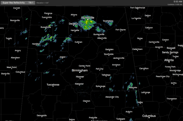
The sky is mostly cloudy, and temperatures are in the upper 50s and low 60s at daybreak. Expect a high in the upper 60s today; clouds will persist and we will maintain the risk of scattered showers, but nothing heavy or widespread.
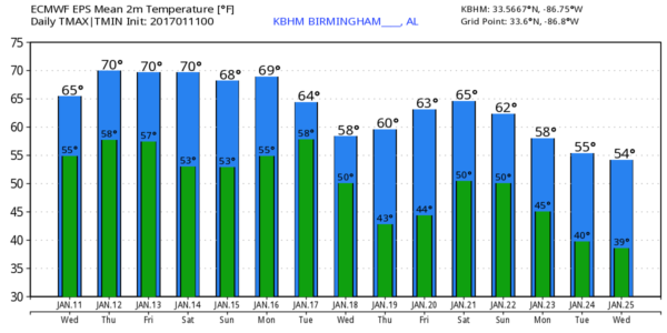
We note the average high for Birmingham on January 11 is 52; based on averages this is the coldest time of the year; the average high slips up to 53 on January 19.
TOMORROW/FRIDAY: An upper ridge will continue to build across the Southeast U.S… pushing highs up into the low 70s both day, a good 20 degrees above average. We will hang on to a small risk of a shower tomorrow; Friday should be dry.
THE ALABAMA WEEKEND: A far cry from last weekend’s ice issues; we project a high between 70 and 73 Saturday and Sunday with a mix of sun and clouds. The upper ridge will keep Alabama dry, while some places across the Central U.S. deal with freezing rain and ice (in a broad zone from Amarillo to Cincinnati).
NEXT WEEK: The GFS continues to trend slower with the next weather feature to the west; it now hints our next decent chance of rain will come around Wednesday of next week. And, for now, it doesn’t look like a really big event, and no risk of severe weather. See the Weather Xtreme video for maps, graphics, and more details.
35 YEARS AGO: On January 11, 1982, the low in Birmingham was 1 below zero. Then, in coming days, Birmingham would experience one of its worst ice storms of the twentieth century as freezing rain and sleet swept into Central Alabama about midday on January 12, 1982. Morning forecasts had called for a winter storm watch for occasional sleet and freezing rain that would arrive by sundown. By mid-morning, as freezing rain and sleet across South Alabama was spreading rapidly north, the watch was changed to a winter storm warning.
The snow arrived about 8 hours earlier than anticipated in the Birmingham area and quickly changed over to a mix of freezing rain and sleet that turned roads in skating rinks. Thousands of motorists had to abandon their vehicles on roads and hike home or spend the night in shelters. Brookwood Village mall became a huge shelter. So many wrecks occurred that the Birmingham Police Department could not answer the calls for accident investigation. As temperatures hovered near the freezing mark through the night, freezing rain created a thick coating on all exposed objects. Trees snapped, pulling down power lines and putting as many as 750,000 Alabamians in the dark. A state of emergency was declared in Alabama and National Guard Armories were opened to serve as shelters.
WORLD CLASS TENNIS RETURNS TO BIRMINGHAM: The BJCC will host the first-round tie against Switzerland February 3rd-5th. Single-day tickets are on sale now. Get them while they last! Buy tickets here.
WEATHER BRAINS: Don’t forget you can listen to our weekly 90 minute netcast anytime on the web, or on iTunes. This is the show all about weather featuring many familiar voices, including our meteorologists here at ABC 33/40.
CONNECT: You can find me on all of the major social networks…
Facebook
Twitter
Google Plus
Instagram
I will be speaking at a meeting of the Alabama Golf Course Superintendents Association in Oxford… look for the next Weather Xtreme video here by 4:00 this afternoon. Enjoy the day!
Category: Alabama's Weather
About the Author (Author Profile)
James Spann is one of the most recognized and trusted television meteorologists in the industry. He holds the AMS CCM designation and television seals from the AMS and NWA. He is a past winner of the Broadcast Meteorologist of the Year from both professional organizations.Subscribe
If you enjoyed this article, subscribe to receive more just like it.


