

Spring-Like Afternoon; Changes Ahead
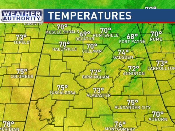
SPRING FEVER: Temperatures have blown past the forecast highs today, and most places are in the low to mid 70s this afternoon, 15-20 degrees above average for the last day of January in Alabama. The sky is sunny, and we have no rain anywhere near our state.
TONIGHT: Look to the west immediately after sunset and you will be wowed by the show that the moon, Venus and Mars will be putting on for your viewing pleasure. According to WeatherBrains’ Resident Astronomer Tony Rice (@RTPHokie), the trio will form a nearly right triangle in the western sky this evening. See the blog post below this one for more details. The sky will be crystal clear.
REST OF THE WEEK: Tomorrow will be another dry and very mild day, but clouds will begin to increase ahead of a cold front approaching from the north. The high tomorrow will be in the upper 60s, not quite as warm as today. Then, look for a cooling trend Thursday and Friday; both days will be mostly cloudy with a few periods of light rain likely as the surface front drifts slowly southward through Central Alabama. The high Thursday will be close to 60, then dropping into the mid 50s Friday. Some places over far North Alabama could hold in the chilly 40s all day Friday.
THE ALABAMA WEEKEND: For now, Saturday still looks cool and dry with a partly sunny sky and a high in the 50s. Then, on Sunday, we will mention a chance of rain during the day with an upper trough approaching. Best chance of rain will be over the northern half of the state, and amounts should be generally under 1/2 inch. Otherwise, Sunday will be mostly cloudy and mild with a high in the 60s.
NEXT WEEK: Looks like an active pattern, and getting the timing down far in advance will be difficult. For now and Tuesday look like mostly cloudy and mild days with only widely scattered showers; highs will be close to 70 degrees. Then, a cold front with good upper support will bring rain and storms to the state late Wednesday, Wednesday night, and Thursday. There could be a few strong storms involved, but for now the overall severe weather threat looks low. Much colder air will follow the front by Friday with highs potentially dropping into the 40s with a brisk north wind. See the Weather Xtreme video for maps, graphics, and more details.
As always, watch me for the full weather story on ABC 33/40 News this evening at 4, 5, 6, and 10:00!
WEATHER BRAINS: Don’t forget you can listen to our weekly 90 minute netcast anytime on the web, or on iTunes. This is the show all about weather featuring many familiar voices, including our meteorologists here at ABC 33/40. We will produce this week’s show tonight at 8:30 CT… you can watch it live here.
CONNECT: You can find me on all of the major social networks…
Facebook
Twitter
Google Plus
Instagram
Pinterest
Snapchat: spannwx
I enjoyed seeing the kids from West Alabama Christian School in Demopolis this morning… and many of the parents as well. Be looking for them on the Pepsi KIDCAM today at 5:00 on ABC 33/40 News! The next Weather Xtreme video will be posted here by 7:00 a.m. tomorrow…
Category: Alabama's Weather
About the Author (Author Profile)
James Spann is one of the most recognized and trusted television meteorologists in the industry. He holds the AMS CCM designation and television seals from the AMS and NWA. He is a past winner of the Broadcast Meteorologist of the Year from both professional organizations.Subscribe
If you enjoyed this article, subscribe to receive more just like it.


