

Severe Storms Possible Late Tomorrow/Tomorrow Night
WARM, DRY DAY AHEAD: We expect a partly sunny sky across the great state of Alabama today with a high in the 81-85 degree range this afternoon. During the peak of the daytime heating, a few isolated showers could form, but the chance of any one spot getting wet is only about one in ten.
To the west, very active weather will continue, and we will watch storm development over Arkansas and Louisiana this afternoon where an “enhanced risk” of severe storms has been defined.
SEVERE WEATHER THREAT: A deep surface low, supported by a strong upper trough, will be over Missouri tomorrow afternoon, and a moist, unstable airmass will be in place across Alabama. While it still looks like thunderstorms will move along the Gulf Coast tomorrow, models have backed off on the size and strength, suggesting it won’t have much impact on the atmosphere over the northern half of the state.
SPC now has a “moderate risk” up for the far northwest corner of the state, with an “enhanced risk” west of a line from Huntsville to Carbon Hill to Gordo. The standard “slight risk” extends as far east as Anniston, Montgomery, and Atmore. A “marginal risk” covers the rest of East and Southeast Alabama.
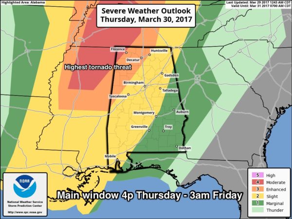
TIMING: The main window for strong to severe storms in Alabama will come from 4pm tomorrow through 3am Friday. Storms will initially move into the far west and northwest part of the state late tomorrow, then progressing eastward tomorrow night.
THREATS: Within the enhanced risk over Northwest Alabama, tornadoes are very possible along with large hail and damaging wind. The tornado threat is lower over the rest of the state (in the “slight” and “marginal” risk areas). A few strong tornadoes are possible in the “moderate” risk over Northeast Mississippi, West Tennessee, and the far northwest tip of Alabama.
RAIN: Rain amounts of around 1 inch are expected; no flooding issues.
CALL TO ACTION: Be sure you have a way of getting warnings; a NOAA Weather Radio is the baseline, and a good smart phone app is the other tier. Identify the safe place in your home, and be sure everyone knows where it is. And, in that safe place have helmets for everyone, along with hard sole shoes and preferably a portable airhorn in case you need help.
FRIDAY AND THE WEEKEND: Models are faster now with the end of the rain… looks like Friday will be a mostly sunny day with a high in the 70s. The weekend will be very nice; Saturday will be sunny with a high between 76 and 79, and Sunday will feature a high in the low 80s with a mix of sun and clouds. Cooler spots will visit the 40s early Saturday morning.
NEXT WEEK: Global model data suggests the wave train stays active, with a chance of strong to severe storms Monday, and then again Thursday. See the Weather Xtreme video for maps, graphics, and more details.
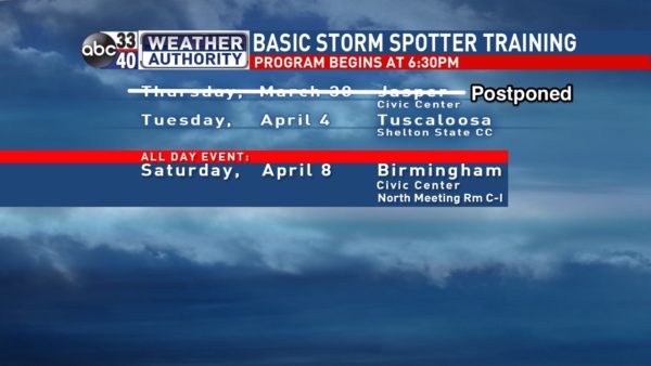
SPOTTER TRAINING TOMORROW NIGHT IN JASPER POSTPONED: Due to the threat of severe storms (somewhat ironic), the spotter training planned for tomorrow evening in Jasper will be rescheduled; next session is next Tuesday at Shelton State in Tuscaloosa. The big event is April 8 at the BJCC in Birmingham when the basic and the advanced class will be offered; that will run from 9am until 2pm… it will be in North Meeting Rooms C-I. Attendees will go up the elevator to the 2nd floor for the North Meeting Room.
Click here to see the Beach Forecast Center page. Save Up To 25% on Spring Break Beach Vacations on the Alabama Gulf Coast with Brett/Robinson! The Beach Forecast is partially underwritten by the support of Brett/Robinson Vacation Rentals in Gulf Shores and Orange Beach. Click here to see Brett/Robinson’s best beach offers now!.
WEATHER BRAINS: Don’t forget you can listen to our weekly 90 minute netcast anytime on the web, or on iTunes. This is the show all about weather featuring many familiar voices, including our meteorologists here at ABC 33/40.
CONNECT: You can find me on all of the major social networks…
Facebook
Twitter
Google Plus
Instagram
Pinterest
Snapchat: spannwx
I have a weather program this morning at Christ Harbor Pre-School in Northport… look for the next Weather Xtreme video here by 4:00 this afternoon. Enjoy the day!
Category: Alabama's Weather, ALL POSTS
About the Author (Author Profile)
James Spann is one of the most recognized and trusted television meteorologists in the industry. He holds the AMS CCM designation and television seals from the AMS and NWA. He is a past winner of the Broadcast Meteorologist of the Year from both professional organizations.Subscribe
If you enjoyed this article, subscribe to receive more just like it.


