

New Day One Severe Weather Outlook is Out
The new Day One Severe Weather Outlook for today is out. It will go into effect at 7 a.m. CDT. Here is the graphic from the SPC.
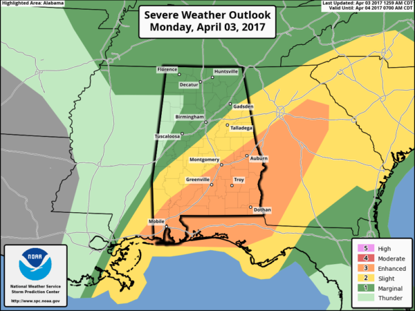
The severe threat is pushed a little further south and downgraded a bit from the day two issued Sunday afternoon. The main threat is south of I-59 and the worst of it for areas east of I-65 and south of I-85.
The airmass being transported into Louisiana, southern Mississippi and coastal Alabama and Northwest Florida is about as moist as has ever been measured by upper air balloons. This airmass will be overlain by a dry elevated mixed layer, like we ofter see over the Southern Plains. This situation leads to decent buoyancy and instability to the south of the warm front.
Strong mid level flow will produce the threat of damaging winds with stronger updrafts.
The moderate risk was dropped back to enhanced an the risk trimmed to the south because the system is going to be primarily a line of storms with a more north south orientation. This limits the tornado threat and the wind damage threat respectively. But hail and wind damage will be the main threats. We can’t rule out an isolated tornado associated with any convection that forms ahead of the main line or in association with any mesoscale convective vortexes that form, but the chance is small.
We will have another update just by 3:30 a.m. CDT.
Category: ALL POSTS, Severe Weather
About the Author (Author Profile)
Bill Murray is the President of The Weather Factory. He is the site's official weather historian and a weekend forecaster. He also anchors the site's severe weather coverage. Bill Murray is the proud holder of National Weather Association Digital Seal #0001 @wxhistorianSubscribe
If you enjoyed this article, subscribe to receive more just like it.


