

Quick Peek at the GFS and NAM Evening Runs
The NAM is in and the GFS is out to 84 hours. No real surprises.
GFS – 4 PM TOMORROW
The GFS is about the same strength with the low, perhaps a little further south. Intensity at 4 p.m. about 995 mb.
Dewpoints in the upper 60s across the I-20 Corridor with lower 70s temperatures, with lower 80s temps and lower 70s dewpoints in the I-85 Corridor. That means the juicier air would possibly be from Montgomery to Auburn.
Strongly veered surface winds out of the southwest, which is good news. Tornadoes like backed (SE) surface winds.
Breezy across the area, with average winds around 15 mph.
Plenty of dry air aloft, which aids severe storms. 85-90 knots of jetstream winds, which aid storm development and North and Central Alabama are in a favorable zone for a jetstream wind maximum over Mississippi.
Decent lapse rates over the area. Best just west of I-59 (7.3 C/km). This is moderately strong for updrafts.
Surface based CAPEs around 2,000 joules east of I-59 with over 3,000 joules across South Central Alabama. Lifted index values agree, with -8 to -9 to as high as -10 around Montgomery/Auburn.
Lifted Condensation Level heights are favorable for tornadoes, but you have to have all the other parameters. We just check this to make sure the LCL heights AREN’T a problem because they can squash tornadoes.
Plenty of bulk shear (60 knots) for organized storms.
Decent Energy Helicity Index values, but more modest Supercell Composite values.
NAM – 4 PM TOMORROW
Much stronger Energy Helicity Index, which combines instability and low level shear. Some scary looking low level EHI values.
Surface based CAPE values off the charts along and east of I-65, running 4,000-5,000 joules in spots.
Lapse rates are strong along and east of I-59.
60 knots of bulk shear for organized storms.
Significant tornado parameter values of 2-4 east of I-65. Anything greater than 1 is a concern. STP values were double digits on April 27, 2011 for our generational outbreak.
Here is a forecast sounding for the Heflin area around 1 p.m.
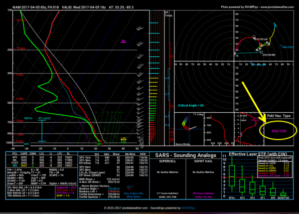
Look at the Possible Hazard Type on the right side. It shows PDS TOR for particularly dangerous situation tornado. That is concerning.
Now the NAM does tend to overdo things, so take this with a grain of salt, but it does present a worst case scenario that could produce several strong to violent long track tornadoes over the eastern half of the state Wednesday afternoon.
The GFS represents a potential best case scenario with potentially a thin line of thunderstorms with a high potential for damaging winds and only smaller tornadoes.
The most likely case is that we will see a broken line of storms form near or west of I-65 during the early afternoon, with several of them becoming severe. Some will produce tornadoes, damaging winds and hail.
NEW SPC OUTLOOK SHORTLY
The new SPC Day One severe weather outlook will be out at 1 a.m. It will be interesting to get the experts’ opinion. If they maintain a moderate risk, it may mean a more cautious wait and see take on the situation. A high risk would mean they are more all in on the concept of supercells and potentially strong to violent tornadoes.
STILL WATCHING FOR STORMS DURING THE EARLY MORNING HOURS
All of this discussion has been about part two of this system. The first will be storms that form along a northward moving warm front just before dawn and move northeast through the morning hours. Those storms could be strong with hail and gusty winds. There could be a few warnings with them. Can’t rule out a sneaky tornado as well. So pay attention to posisble warnings in the 4-10 a.m. time frame.
UP ALL NIGHT
We will have updates throughout the night and continuous team coverage of the severe weather episode all day and into the evening tomorrow.
Category: Alabama's Weather, ALL POSTS
About the Author (Author Profile)
Bill Murray is the President of The Weather Factory. He is the site's official weather historian and a weekend forecaster. He also anchors the site's severe weather coverage. Bill Murray is the proud holder of National Weather Association Digital Seal #0001 @wxhistorianSubscribe
If you enjoyed this article, subscribe to receive more just like it.


