

Strong Storm Affecting Lauderdale & Colbert Counties
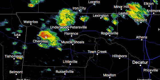
At 255 PM CDT, Doppler radar was tracking a strong thunderstorm near Cherokee, or 13 miles west of Sheffield, moving northeast at 15 mph. Nickel size hail, frequent lightning, and winds in excess of 30 mph will be possible with this storm.
Therefore the NWS Huntsville has issued a Significant Weather Advisory for Western Lauderdale and Northwestern Colbert counties until 3:30PM CDT.
Locations impacted include…
Florence, Cherokee, Underwood-Petersville, Wright, Barton, Oakland, Threet and Cloverdale.
Very heavy rainfall is also occurring with this storm and may lead to localized flooding. Do not drive your vehicle through flooded roadways.
Category: ALL POSTS
About the Author (Author Profile)
Scott Martin is an operational meteorologist, professional graphic artist, musician, husband, and father. Not only is Scott a member of the National Weather Association, but he is also the Central Alabama Chapter of the NWA president. Scott is also the co-founder of Racecast Weather, which provides forecasts for many racing series across the USA. He also supplies forecasts for the BassMaster Elite Series events including the BassMaster Classic.Subscribe
If you enjoyed this article, subscribe to receive more just like it.


