

Radar Update at 12:30PM
HEADS UP GUIN
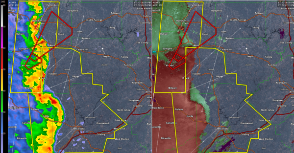
Strong rotation moving into southwestern Marion County. Possible tornado heading for Guin. Tornado warning for Marion, Fayette and Lamar Counties.
HEADS UP TUSCALOOSA COUNTY
Very strong indications of damaging winds pushing into NW Tuscaloosa County from Pickens. This will move into southern Fayette County as well. You could even see a spinup tornado along this line. This should stay north of Tuscaloosa and Northport even though you are in the warning.
GENERAL UPDATE
We have a line of strong to severe thunderstorms that have pushed into the western counties of the state, with a few spots in that line that has reached severe limits. We currently have two tornado warnings in effect for portions of Lamar County until 12:30PM, and the other is in effect for portions of Pickens County until 12:15PM.
MORE STORMS LATER
This line of storms will be the first wave that is expected to move through the state today.
Category: ALL POSTS, Severe Weather
About the Author (Author Profile)
Scott Martin is an operational meteorologist, professional graphic artist, musician, husband, and father. Not only is Scott a member of the National Weather Association, but he is also the Central Alabama Chapter of the NWA president. Scott is also the co-founder of Racecast Weather, which provides forecasts for many racing series across the USA. He also supplies forecasts for the BassMaster Elite Series events including the BassMaster Classic.Subscribe
If you enjoyed this article, subscribe to receive more just like it.


