

Strong Storms Possible Later Today
ACTIVE AFTERNOON POSSIBLE: There is just one lone shower on radar at daybreak, on the Greene/Pickens County line south of Aliceville. Temperatures are in the upper 60s and low 70s with a mostly fair sky.
There is potential for strong storms across the state later today and early tonight; SPC maintains a “slight risk” of severe storms for about the northern half of the state…

Either a cluster of storms, or an outflow boundary, is expected to move into Alabama from the northwest later today, and forecast atmospheric conditions suggest storms that form could produce strong, possibly damaging winds in spots.
However, it is interesting to note that both the high resolution models, the NAM and the HRRR, show absolutely nothing across Alabama this afternoon. It could very well be an “all or nothing” situation, and overall forecast confidence is fairly low on thunderstorm initiation this afternoon.
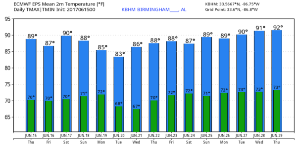
One way or another, the day will be very warm and very humid with a partly sunny sky, and a high between 87 and 90 degrees this afternoon.
TOMORROW THROUGH THE WEEKEND: We expect pretty routine summer weather on these three days. Partly sunny, hot, humid with the risk of “scattered, mostly afternoon and evening showers and thunderstorms”. Afternoon storms will be random, and no way of knowing in advance exactly when and where they pop up. The good ole Alabama summer thunderstorm lottery. Highs will be in the 88-91 degree range.
NEXT WEEK: Drier air tries to creep into North Alabama Tuesday and Wednesday, but that doesn’t happen too often in late June, and for now we will roll with a persistence forecast featuring more classic summer weather and near average temperatures. See the Weather Xtreme video for maps, graphics, and more details.
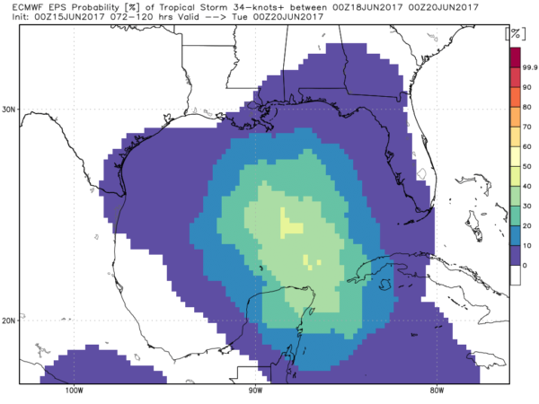
TROPICS: Global models continue to suggest a tropical low will form next week near the tip of the Yucatan Peninsula. The ECMWF ensemble shows the highest probability of tropical storm formation over the Central Gulf early next week; both the Euro and the GFS drift it westward back toward the coast of Mexico, or the southern tip of Texas. Remains to be seen if anything develops at all, or exactly where it goes… just something to watch for now. NHC now shows a 50 percent chance of development.
BEACH FORECAST: Click here to see the AlabamaWx Beach Forecast Center page. The Beach Forecast is partially underwritten by the support of Brett/Robinson Vacation Rentals in Gulf Shores and Orange Beach. Click here to see Brett/Robinson’s Own Your Summer specials now!
WEATHER BRAINS: Don’t forget you can listen to our weekly 90 minute netcast anytime on the web, or on iTunes. This is the show all about weather featuring many familiar voices, including our meteorologists here at ABC 33/40.
CONNECT: You can find me on all of the major social networks…
Facebook
Twitter
Google Plus
Instagram
Pinterest
Snapchat: spannwx
Look for the next Weather Xtreme video here by 4:00 this afternoon… enjoy the day!
Category: Alabama's Weather, ALL POSTS, Weather Xtreme Videos
About the Author (Author Profile)
James Spann is one of the most recognized and trusted television meteorologists in the industry. He holds the AMS CCM designation and television seals from the AMS and NWA. He is a past winner of the Broadcast Meteorologist of the Year from both professional organizations.Subscribe
If you enjoyed this article, subscribe to receive more just like it.


