

A Quick Check On Our Weather At 4:30PM
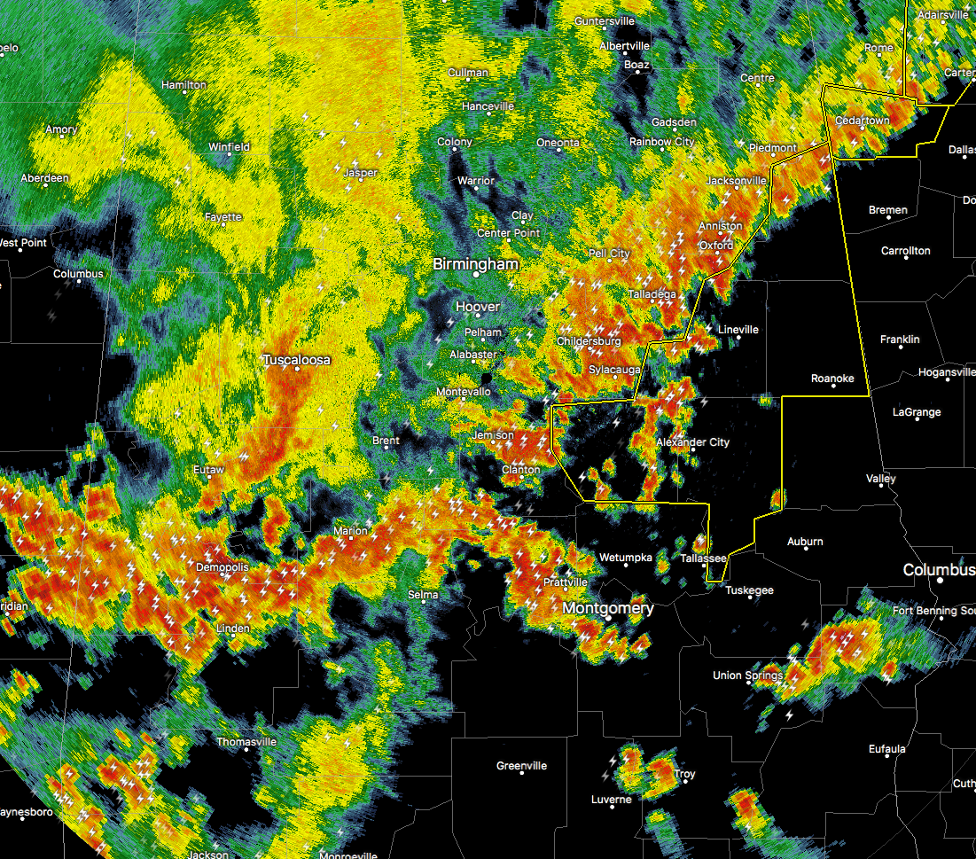
Here is the radar as of 4:18PM, showing that much of the stronger storm activity has now pushed through much of Central Alabama, and is lined up from Heflin to Alexander City to Selma to Cuba, with a finger of storms stretching out ahead of the line from Billingsley down to Montgomery and Pike Road.
We are currently down to one Severe Thunderstorm Warning that has been issued for Parts Of Calhoun, Clay, Cleburne, Coosa, Randolph, And Tallapoosa Counties Until 5:30PM. The main threat with this part of the line of storms will be from damaging straight-line winds up to 60 MPH or more, and some hail is possible. There is no tornado threat with this system.
Behind the main line of storms, we will have to deal with some light to moderate rainfall, but the good news is that the threat for severe weather is over once the main part of the line passes your location.
We have multiple reports of trees downed across the area, along with scattered power outages. We did get a report of the roof blown off of a business in Bessemer.
Rain will be coming to an end by midnight, and overnight lows tonight will be in the upper 60s to the lower 70s. Tomorrow we will return back to the typical summertime forecast… A mix of sun and clouds with scattered to numerous showers and thunderstorms possible across Central Alabama, with the best chances coming in the southern portion of the area. Highs will be back up in the upper 80s to the lower 90s across Central Alabama.
Category: Alabama's Weather, ALL POSTS
About the Author (Author Profile)
Scott Martin is an operational meteorologist, professional graphic artist, musician, husband, and father. Not only is Scott a member of the National Weather Association, but he is also the Central Alabama Chapter of the NWA president. Scott is also the co-founder of Racecast Weather, which provides forecasts for many racing series across the USA. He also supplies forecasts for the BassMaster Elite Series events including the BassMaster Classic.Subscribe
If you enjoyed this article, subscribe to receive more just like it.


