

Mix Of Sun And Storms For Alabama
RADAR CHECK: We have a few scattered thunderstorms across parts of Central Alabama early this morning… moving southeast…
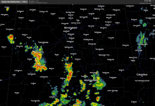
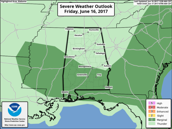
A moist airmass remains parked across the state today, and with a broad upper trough over the region and a weak northwest flow aloft, we will maintain the chance of scattered showers and thunderstorms through early tonight. The rain won’t be as widespread as yesterday… but more scattered in nature. Some of the afternoon storms will be strong; SPC has a “marginal risk” of severe weather defined for about the southern half of the state… areas generally along and south of U.S. 82.
The main threat will come from strong straight line winds. And, away from the thunderstorms we expect a mix of sun and clouds today with a high in the mid to upper 80s.
THE ALABAMA WEEKEND: Not much change. Intervals of sun tomorrow and Sunday, and once again potential for scattered showers and thunderstorms, mostly during the afternoon and evening hours. Afternoon highs in the 87 to 90 degree range. Very typical weather for June.
NEXT WEEK: Showers and storms should be more numerous Monday as a surface front approaches from the west, and there is evidence the air could be a little drier Tuesday through Thursday with fewer showers and slightly lower humidity levels. See the Weather Xtreme video for maps, graphics, and more details.
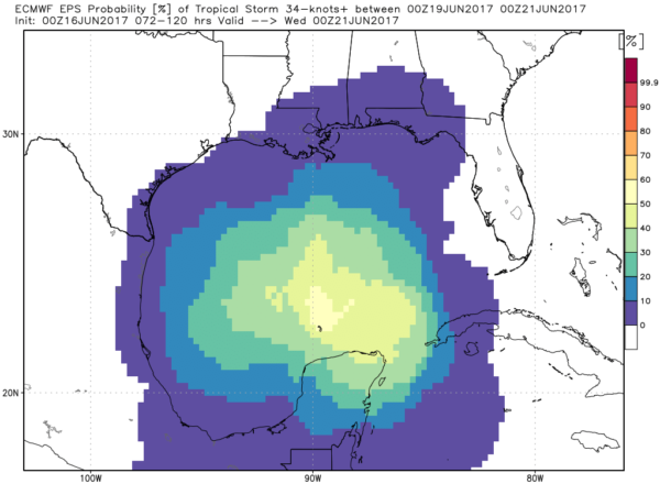
TROPICS: Global models continue to develop a broad tropical low over the far southern Gulf of Mexico next week. The reliable European (ECMWF) suggests the low will drift westward, in the general direction of the Mexican coast south of Brownsville, Texas. We do note the Canadian global model (GEM) develops a significant tropical system and moves it toward the Florida Panhandle, but that is an outlier and is rejected for now. Bottom line… if you have a beach trip planned next week to places like Gulf Shores or Panama City Beach, odds are good you won’t have any trouble, but just keep an eye on it.
BEACH FORECAST: Click here to see the AlabamaWx Beach Forecast Center page. The Beach Forecast is partially underwritten by the support of Brett/Robinson Vacation Rentals in Gulf Shores and Orange Beach. Click here to see Brett/Robinson’s Own Your Summer specials now!
WEATHER BRAINS: Don’t forget you can listen to our weekly 90 minute netcast anytime on the web, or on iTunes. This is the show all about weather featuring many familiar voices, including our meteorologists here at ABC 33/40.
CONNECT: You can find me on all of the major social networks…
Facebook
Twitter
Google Plus
Instagram
Pinterest
Snapchat: spannwx
I have a live shot out at Regions Field later today, so no afternoon Weather Xtreme video, but I will post forecast notes here on the blog. Enjoy the day…
Category: Alabama's Weather, ALL POSTS, Weather Xtreme Videos
About the Author (Author Profile)
James Spann is one of the most recognized and trusted television meteorologists in the industry. He holds the AMS CCM designation and television seals from the AMS and NWA. He is a past winner of the Broadcast Meteorologist of the Year from both professional organizations.Subscribe
If you enjoyed this article, subscribe to receive more just like it.


