

Much Quieter At Midday, But More Storms Could Be On The Way
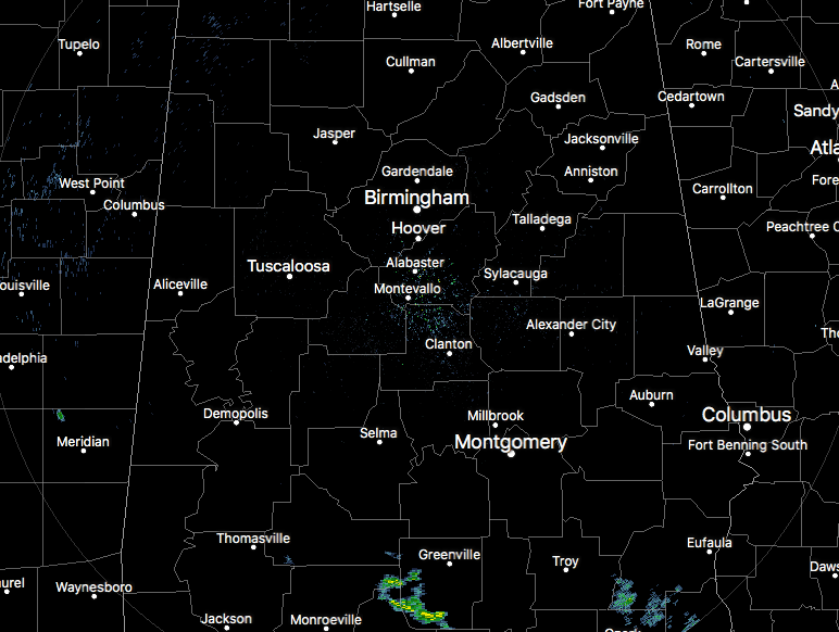
RADAR CHECK AT 11:30AM
For most of the Central Alabama area as we approach the midday hour, skies are partly to mostly cloudy, but the good news is that radar is pretty quiet at this point. The only rain showing up in the area are a few light showers down in the southern parts of Pike and Barbour counties. These are moving to the southeast and will be out of the area shortly.
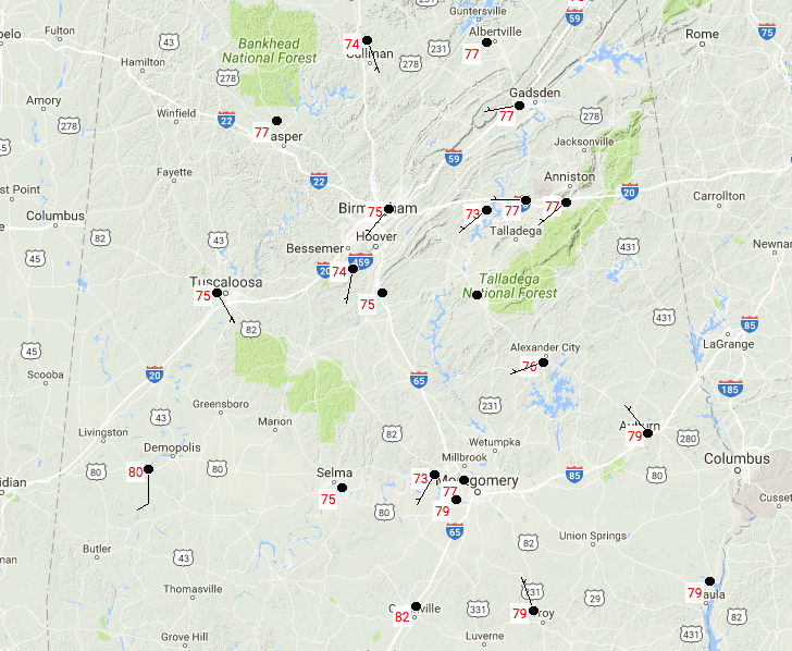
TEMPERATURES AT 11:30AM
With decent cloud cover and the atmosphere still trying to recover from yesterday’s storms, temperatures are cooler than what they have been for the past few days at this same time. We’re currently running in the mid to upper 70s across all of Central Alabama, with the only spot at 80 degrees being Demopolis.
FOR THE REST OF THE DAY
We’ll have partly to mostly cloudy skies throughout Central Alabama for the rest of the day, and there is the general summertime risk for scattered afternoon and evening showers and thunderstorms. The better rain chances will be in the southern parts of the area. Afternoon highs will be in the upper 80s to the lower 90s throughout the area. There is the possibility of a MCS forming out to our west near the Mississippi River and will head in our direction, but it may dissipate before reaching the area. If it holds together, the western counties will have a better risk for showers and storms tonight, some of which could be strong to marginally severe. Otherwise, and showers out there will dissipate before midnight, and lows will be in the lower 70s.
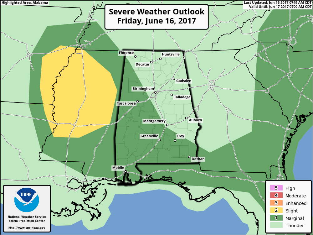
The SPC had increased the area of Marginal Risk for severe storms to now include parts of western Alabama west of a line from Prattville to Montevallo to Phil Campbell. There thinking is that a MCS could form and move into the western parts of the state this evening. Timing and exact location of this is not exactly known at this point, and models have a hard time depicting these type of storms. Main risks will be from damaging wind gusts and some hail. There will be no threat of tornadoes.
THE WEEKEND
We’ll have a mix of sun and clouds throughout the daytime hours on both days with the general risk for scattered mainly afternoon and evening showers and storms. Afternoon highs will be in the upper 80s to the lower 90s across Central Alabama.
HEADING TO THE BEACH
For a detailed look at the weather from Fort Morgan over to Panama City Beach, click here to see the AlabamaWx Beach Forecast Center page. The Beach Forecast is partially underwritten by the support of Brett/Robinson Vacation Rentals in Gulf Shores and Orange Beach. Click here to see Brett/Robinson’s Own Your Summer specials now!
TROPICAL UPDATE
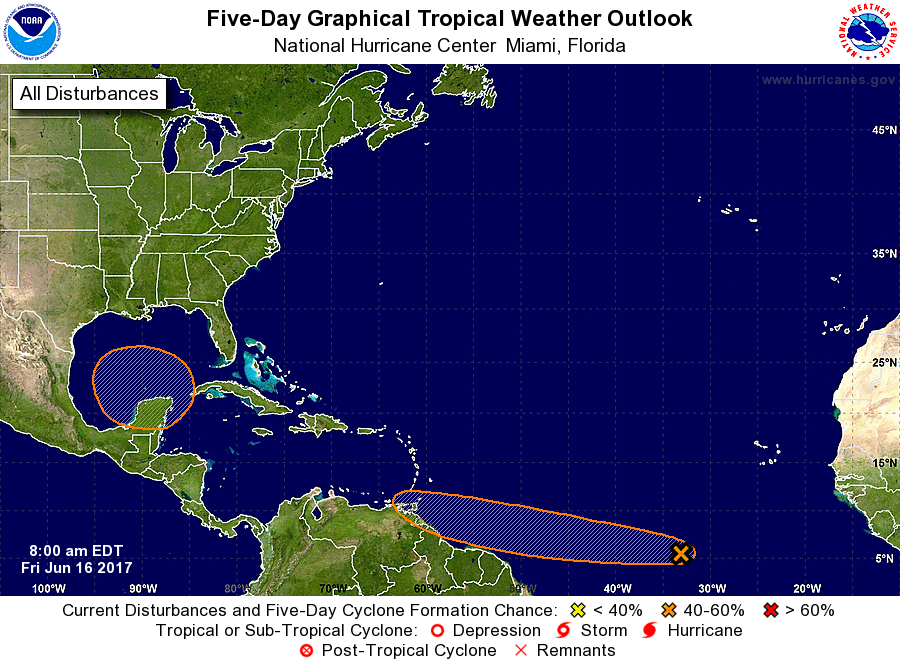
Global models continue to develop a broad tropical low over the far southern Gulf of Mexico next week. The reliable European (ECMWF) suggests the low will drift westward, in the general direction of the Mexican coast south of Brownsville, Texas. We do note the Canadian global model (GEM) develops a significant tropical system and moves it toward the Florida Panhandle, but that is an outlier and is rejected for now. Bottom line… if you have a beach trip planned next week to places like Gulf Shores or Panama City Beach, odds are good you won’t have any trouble, but just keep an eye on it.
TODAY IN WEATHER HISTORY
June 16, 1989 – Daytime thunderstorms produced severe weather from northern Florida to the Middle Atlantic Coast. The thunderstorms spawned eight tornadoes, and there were 138 reports of large hail and damaging winds. Thunderstorm winds gusting to 87 mph caused twenty million dollars damage at Columbia SC. Strong thunderstorm winds killed one person at McLeansville NC.
WEATHERBRAINS
It was a great show this week with Lans Rothfusz from the National Severe Storms Laboratory talking about progress on the new severe weather warning paradigm called FACETS. Lans also updated us on Warn on Forecast. Check out the show at www.WeatherBrains.com. You can also subscribe on iTunes.
Category: Alabama's Weather, ALL POSTS
About the Author (Author Profile)
Scott Martin is an operational meteorologist, professional graphic artist, musician, husband, and father. Not only is Scott a member of the National Weather Association, but he is also the Central Alabama Chapter of the NWA president. Scott is also the co-founder of Racecast Weather, which provides forecasts for many racing series across the USA. He also supplies forecasts for the BassMaster Elite Series events including the BassMaster Classic.Subscribe
If you enjoyed this article, subscribe to receive more just like it.


