

Complex Pattern for Week Ahead
To say the weather forecast for the week ahead is complex is almost an understatement. But before we get to that, a flash flood warning is in effect until 8:30 am for portions of Autauga, Elmore Lowndes, and Montgomery counties. A cluster of strong storms developed over this area and with little movement there is a serious risk for flash flooding. Heed the warning – Don’t Drown, Turn Around. Best yet, don’t drive in this area.
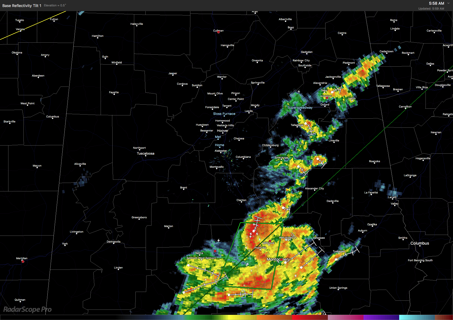
The upper trough and weak low pressure area is responsible for the development of these storms. Outside of the storm areas, warm and muggy conditions exist with temperatures expected to climb from the lower 70s into the middle and upper 80s today. As the weak low pressure area moves southwest, look for additional storms to develop in the heat of the afternoon. I put the risk for showers and storms today at 60 to 70 percent. In fact, SPC has a the standard slight risk for severe thunderstorms in a band along and ahead of the front today from Northeast Texas all the way to northern Vermont that just clips the northwest corner of Alabama. Nearly all of Alabama with the exception of the southeast corner is in a marginal risk area.
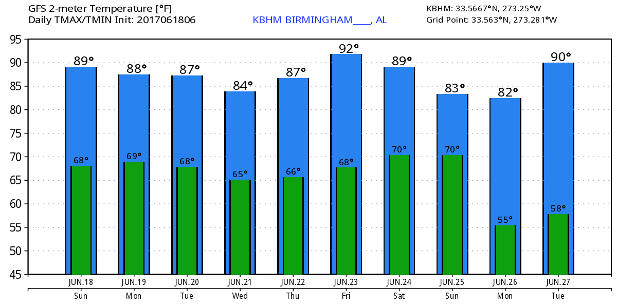
Adding to the upper troughiness and this pesky weak upper low, a cold front extending southwestward from a surface low over the Great Lakes area is forecast to sag into the area on Monday. With a humid air mass in place, showers and thunderstorms are likely. SPC has a marginal risk for severe thunderstorms across North and Central Alabama on Monday, Day 2, as the front sags into the area but begins washing out. The presence of lots of clouds as well as showers is likely to keep high temperatures in the middle 80s.
So far so good, but if the forecast wasn’t complex enough, Tuesday brings a potential tropical feature for us to deal with. The GFS indicates some drier air behind the dissipating front that reaches North Alabama where dew points drop to around 60. I’m not sure the dry air reaches Central Alabama. But by 1 am on Tuesday, the GFS and the ECMWF develop what could be a tropical storm in the Central Gulf. Yes, you read right. The ECMWF and GFS that were miles apart yesterday are in much closer agreement at least for Tuesday, but not identical. Have I mentioned the forecast is somewhat complex? This means that we may see a significant reduction in showers on Tuesday with rain chances around 20 or 30 percent. Highs will likely be down somewhat, too, with highs in the middle 80s.
As you will see from the graphics, I’m very concerned about the high levels of shear the GFS is depicting over the Gulf just north and northwest of where the tropical storm is forecast to develop. Nevertheless, the GFS continues to develop the system and moves it very close to the Florida Panhandle. But the ECMWF takes the system on a sharp left turn and takes it westward toward South Texas. Here’s the spaghetti chart of various models which indicates a clustering of the various tracks into the northern Gulf making the ECMWF somewhat of an outlier.
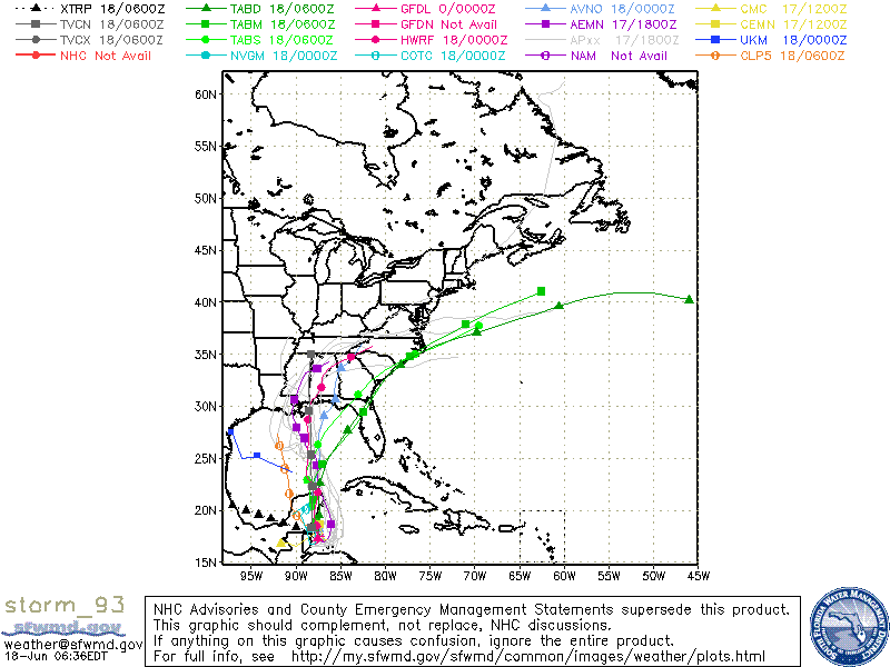
Wednesday the GFS has the tropical system in land over the eastern sections of the Florida Panhandle just west of Tallahassee while the ECMWF has the center just offshore of Brownsville. Needless to say, one of these is wrong. And since the spaghetti chart shows a clustering of the tracks in the northern Gulf Coast from New Orleans to Panama City, I’m inclined to stick closer to the GFS which may not have the exact specific track. This whole situation is still somewhat fluid especially when you consider we have nothing more than an area of disturbed weather right now. The large amount of shear over the Gulf is also troubling, so we may be dealing with a fairly weak tropical system.
Based on the GFS, weather across North and Central Alabama on Wednesday may actually be fairly nice if the track shown by the GFS is actually correct. This track puts us on the northern and western side of the storm where we can expect to see sinking motion. So we might actually have a rather sunny day while the coastal area of Alabama and the Florida Panhandle deal with tropical storm conditions. I always find this scenario to be amazing.
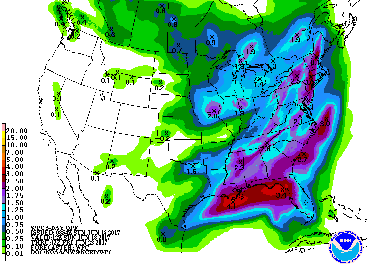
With the front bringing good chances for showers and storm on Monday and the potential for a tropical system affecting the Gulf Coast area at midweek, the QPC chart reflects both of these with 1.5 to 2.5 inches over the northern half of Alabama and the potential for 3 to 5 inches along the immediate coast.
Thursday the upper trough and that upper weakness move off to the east. This should return us to more daily showers driven by the heating of the afternoon. Slight ridging takes place for the end of the week and into the weekend so highs could climb close to 90 by Friday. A fairly strong trough comes across the Central Mississippi River Valley on Sunday which drags another front into the Southeast. Showers should be fairly prevalent for Saturday but ending from the northwest on Sunday afternoon. The highs Sunday will fall back to the middle 80s.
The weather at the beach for the next week is expected to be pretty stormy with passing showers and storms just about each day. Highs will be in the middle 80s. Plus there is the potential for a weak tropical system in the Gulf that could produce serious weather issues around the Tuesday-Wednesday time frame. For a detailed look at the weather from Fort Morgan to Panama City Beach, click here to see the AlabamaWx Beach Forecast Center page. The Beach Forecast is partially underwritten by the support of Brett/Robinson Vacation Rentals in Gulf Shores and Orange Beach. Click here to see Brett/Robinson’s Own Your Summer specials now!
Looking into voodoo country, the trough moves by us on Monday, the 26th of June. The upper ridge over the Southwest US spreads into the Central US by the 29th and becomes a big fixture in the weather pattern over the eastern two thirds of the country by July 2nd. This pattern would certainly favor a good deal of heat over the Central and Southeast US.
I’ll be filling in for Meaghan Thomas with the weather at 5 and 10 pm on ABC 3340, so be sure to tune in for the latest. James Spann is taking next week off, so I’ll be filling in for him here with one-a-day Weather Xtreme Videos. I’ll try to have it posted around 7:00 to 7:30 am each morning. Enjoy your day, stay dry, and Godspeed.
-Brian-
Category: Alabama's Weather, ALL POSTS
About the Author (Author Profile)
Brian Peters is one of the television meteorologists at ABC3340 in Birmingham and a retired NWS Warning Coordination Meteorologist. He handles the weekend Weather Xtreme Videos and forecast discussion and is the Webmaster for the popular WeatherBrains podcast.Subscribe
If you enjoyed this article, subscribe to receive more just like it.


