

A Brief Check On Our Weather Situation At 5:15PM
RADAR CHECK
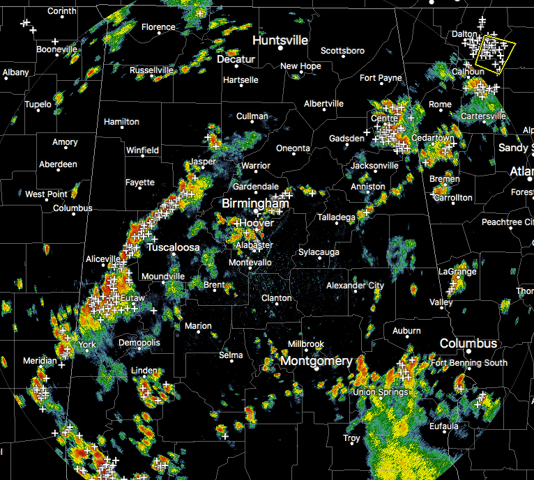
At 5:05 PM, we have a good bit of showers and storms across Central Alabama at this point. Most of the larger storms are lined up stretching from Cuba and Livingston, to the north-northeast through Gordo and to Oakman and Parrish. A Significant Weather Advisory was just issued for parts of Walker, Tuscaloosa, Pickens, Greene, Sumter, and Fayette counties until 6:00 PM for thunderstorms extending from Boley Springs to Panola. These are moving northward at 5 MPH.
Another big storm is located over much of Cherokee County. This storm is putting down tremendous amounts of rain, along with dangerous cloud-to-ground lightning. Please seek shelter until this storm passes.
We also still have multiple storms affecting Jefferson and Shelby counties, especially from Trussville to the south-southwest through Vestavia and Hoover, and ending just east of Alabaster. I know that this storm is putting down copious amounts of rain, as I am currently in Vestavia at the library. All I know this is going to make my trip back to the house fun. Gotta love traffic.
At this point, there are no severe storms in our area, and the threat is very very low. A few of these storms will become strong with strong gusty winds and torrential rainfall. Precipitable water values are over 2.00 inches over the central parts of the area, so these storms could very easily cause ponding on the roadways and even localized flash flooding.
Most of these will die down and dissipate as we lose sunlight this evening, but a few could linger well into the late night and overnight hours. A few more could actually develop along boundaries that are left over from previous storms that have died off.
Category: Alabama's Weather, ALL POSTS
About the Author (Author Profile)
Scott Martin is an operational meteorologist, professional graphic artist, musician, husband, and father. Not only is Scott a member of the National Weather Association, but he is also the Central Alabama Chapter of the NWA president. Scott is also the co-founder of Racecast Weather, which provides forecasts for many racing series across the USA. He also supplies forecasts for the BassMaster Elite Series events including the BassMaster Classic.Subscribe
If you enjoyed this article, subscribe to receive more just like it.


