

Showers Today, More Numerous Monday/Tuesday
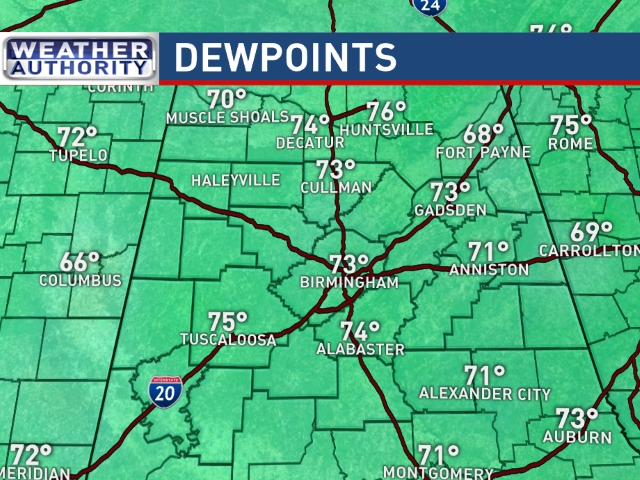
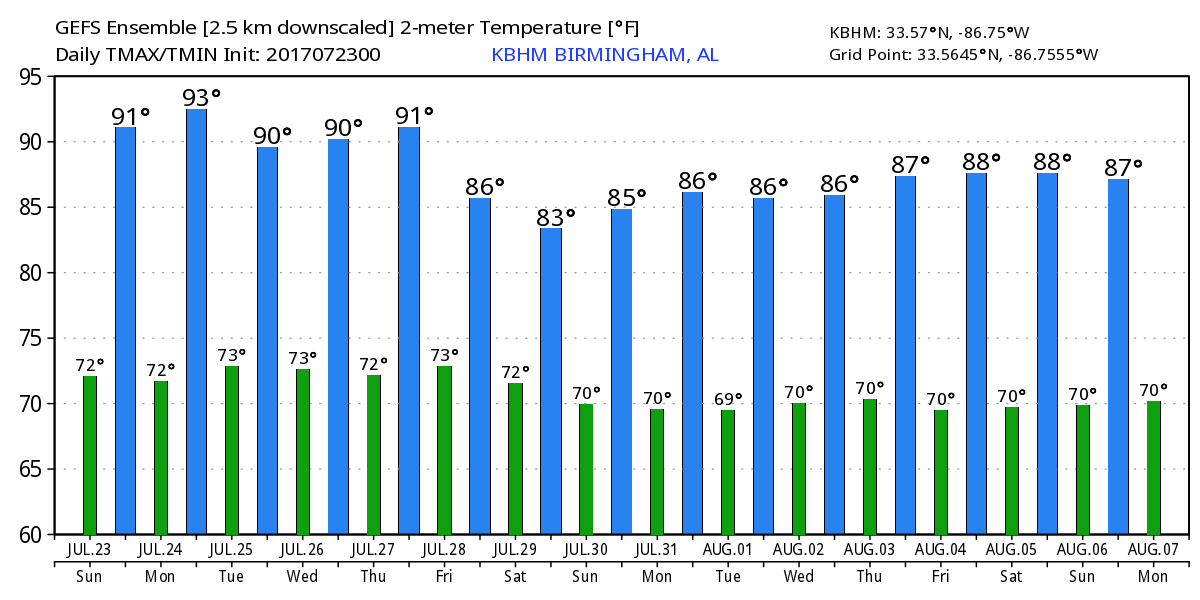
The Southeast US remained under a surface high pressure nosing in from the Atlantic, however, in the upper atmosphere the influence of the big ridge to the west was waning slightly. The National Weather Service has chosen to keep a heat advisory today from 11 am to 9 pm for the area along and west of Interstate 65. While thickness values are gradually dropping, there is still a fairly good likelihood for heat indices to reach the range of 103 to 106 in some locations. Showers while scattered may keep the heat in check in some locations as it did yesterday at Birmingham. The high was only 92 kept in check by showers nearby though none occurred right at the airport. My station in Helena saw 13 hundredths of an inch in a small shower that was accompanied by some lightning. Highs today should reach the 93 to 96 range once again, but those humidity values are up there with dew points running in the lower 70s.
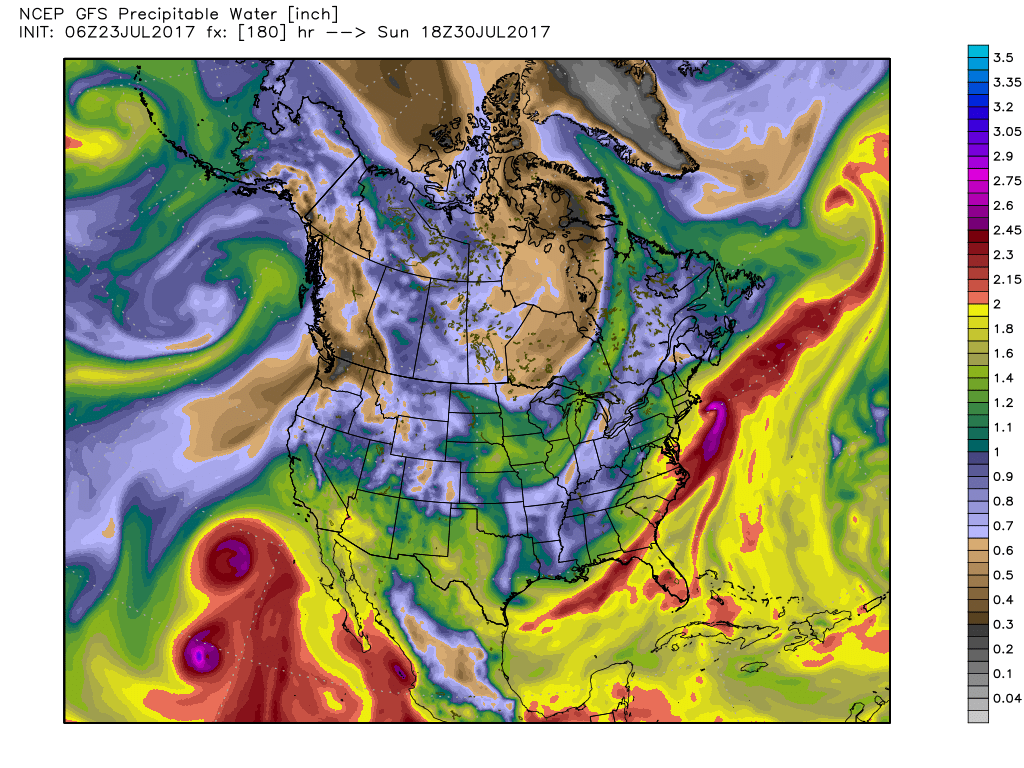
The upper air pattern shows a slight better trough over the East Coast on Monday which will drag a surface front into the Southeast US. With relatively high precipitable water value (around 2 inches), I think showers will be more numerous with better chances for everyone to get some rain. But they will still be showers, so some may still get missed. Highs should be in the lower 90s.
The upper ridge remains close through mid-week, so with the surface boundary washing out, showers and thunderstorms will remain in the forecast. I think Tuesday will be much like Monday with fairly numerous showers and thunderstorms with good coverage of rain. Temperatures remain in the lower 90s for highs.
By the end of the week, late Thursday into Friday, traveling short waves moving across southern Canada will continue to dig into and strengthen the trough over the eastern US. This will once again bring a surface front into the Southeast US. Unlike previous encounters with fronts, there appears to be a reasonably good chance that the trough will be strong enough to see the front push all the way to the Gulf Coast by late Saturday. The front should be the focus for numerous showers and thunderstorms on Friday and early Saturday. Highs should drop back a tad with more clouds and showers so highs Friday will be in the range of 87 to 91.
Sunday the upper trough has carved out a nice niche across the eastern half of the country, so at the surface we should see a very nice day with lowered humidity along with highs only in the upper 80s and plenty of sunshine without the need to mention showers. Of course, keep in mind that Sunday is edging pretty close to voodoo country so we’ll have to see if the GFS is right on this. As the chart below shows, precipitable water values should be below an inch over the northern half of the state.
Rainfall through next Friday morning should be in the range of 1 to 2 inches. Because of the nature of showers, not everyone will see the full amounts. Best chances for showers will come Monday and Tuesday and again on Friday.
All remains quiet across the Atlantic basin where tropical storm formation is not expected through next week. The eastern North Pacific, on the other hand, was quite busy with three storms including Tropical Storms Greg, Irwin, and Hilary. All are expected to remain away from land, but it is worth noting that Hilary is forecast to become a major hurricane
The weather at the beach is fairly typical for July with daily chances for a passing shower along with highs in the upper 80s. Click here to see the AlabamaWx Beach Forecast Center page. The beach forecast is partially underwritten by the support of Brett/Robinson Vacation Rentals in Gulf Shores and Orange Beach. Click here to see Brett/Robinson’s Own Your Summer specials now!
Looking into voodoo country, the GFS remains bullish on keeping a fairly strong trough over the eastern US. It’s interesting to note that the trough axis is actually slightly further west than we’ve seen on previous model runs. The troughiness over the East breaks down at the end of the period with a cutoff low over Texas and serious ridging along the East Coast.
James Spann will have the next edition of the Weather Xtreme Video here bright and early on Monday morning. Check back often for notes on Alabama’s weather. Have a great day, mind the heat, respect any showers that form for the potential for lightning. Godspeed.
-Brian-
Category: Alabama's Weather, ALL POSTS
About the Author (Author Profile)
Brian Peters is one of the television meteorologists at ABC3340 in Birmingham and a retired NWS Warning Coordination Meteorologist. He handles the weekend Weather Xtreme Videos and forecast discussion and is the Webmaster for the popular WeatherBrains podcast.Subscribe
If you enjoyed this article, subscribe to receive more just like it.


