

Dry In Alabama As Harvey Approaches Texas
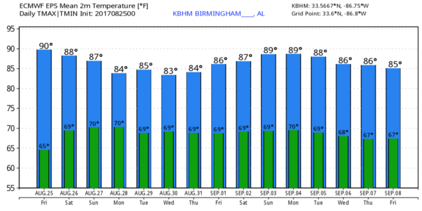
ANOTHER REFRESHING MORNING: Many of the cooler spot are down in the 50s early this morning as we enjoy a preview of fall. Dry, continental air remains over Alabama, and today will be another sunny day with a high in the upper 80s in most spots. Humidity levels will stay low for late August.
OUR WEEKEND: Tomorrow will dry for most of the state with a good supply of sunshine; we will introduce the chance of a few isolated showers Sunday, with the better probability of some rain over the southwest counties of the state. Afternoon highs will remain in the upper 80s.
NEXT WEEK: Any showers will remain isolated Monday and Tuesday, but the chance of rain will increase Wednesday through Friday as some moisture from Hurricane Harvey creeps in from the west. Please understand our rain amounts won’t be in the same universe as what our friends in Southeast Texas will be dealing with in coming days. But a few good tropical downpours are possible over the latter half of the week.
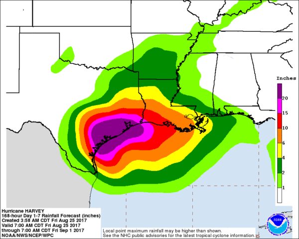
HURRICANE HARVEY APPROACHING THE TEXAS COAST: Harvey is a category two hurricane early this morning with sustained winds of 105 mph. It is expected to be a major, category three hurricane by the time of landfall around midnight tonight with sustained winds of near 125 mph.
Steering currents will be non existent, and it still looks like Harvey will meander around the Texas coastal plain for 4-5 days, setting the stage for catastrophic flooding. Harvey is expected to produce total rain accumulations of 15 to 25 inches and isolated maximum amounts of 35 inches over the middle and upper Texas coast through next Wednesday. During the same time period Harvey is expected to produce total rain accumulations of 7 to 15 inches in far south Texas and the Texas Hill Country eastward through central and southwest Louisiana, with accumulations of up to 7 inches extending into other parts of Texas
and the lower Mississippi Valley. Rainfall from Harvey will cause devastating and life-threatening flooding.
INVEST 92L: A disturbance over South Florida will move northeast slowly this weekend and early next week, and there is a medium chance this becomes a tropical depression or storm off the East Coast of the U.S. No impact on Alabama.
See the Weather Xtreme video for maps, graphics, and more details.
BEACH FORECAST: Click here to see the AlabamaWx Beach Forecast Center page. The Beach Forecast is partially underwritten by the support of Brett/Robinson Vacation Rentals in Gulf Shores and Orange Beach. Click here to see Brett/Robinson’s Hot Deals now!
WEATHER BRAINS: Don’t forget you can listen to our weekly 90 minute netcast anytime on the web, or on iTunes. This is the show all about weather featuring many familiar voices, including our meteorologists here at ABC 33/40.
CONNECT: You can find me on all of the major social networks…
Facebook
Twitter
Google Plus
Instagram
Pinterest
Snapchat: spannwx
I will be speaking today to the senior adults at First Baptist Church of Jasper… look for the next Weather Xtreme video here by 4:00 this afternoon… enjoy the day!
Category: Alabama's Weather, ALL POSTS, Weather Xtreme Videos
About the Author (Author Profile)
James Spann is one of the most recognized and trusted television meteorologists in the industry. He holds the AMS CCM designation and television seals from the AMS and NWA. He is a past winner of the Broadcast Meteorologist of the Year from both professional organizations.Subscribe
If you enjoyed this article, subscribe to receive more just like it.


