

Clouds but Dry for the Weekend
We’re seeing a good deal of cloudiness on satellite imagery, and radar is also picking up on some precipitation aloft, but the sounding suggests that this precipitation will evaporate in the dry layers aloft. Can’t completely rule out a sprinkle. With the sun filtered through the cirrus clouds coming from Harvey, we can expect to see highs in the upper 80s. Still below our seasonal values for the latter part of August. The average high so far for August at the Birmingham Shuttlesworth International Airport was 88.9 degrees, close to 2 degrees below the 30-year monthly average of 90.8 degrees.
As you might imagine, our future weather, especially by midweek and into the end of the week will depend on exactly what Harvey and Harvey’s remnants will do. This certainly qualifies with a “stay tuned” label since the models diverge on their respective solutions. The ECMWF keeps Harvey much stronger than the GFS and moves it into North Central Texas by next weekend. The GFS, on the other hand, weakens Harvey substantially while moving it southwest toward the Rio Grande and eventually washing it out. Needless to say, this leads to a good deal of uncertainty as the forecast gets out to the latter half of the week ahead.
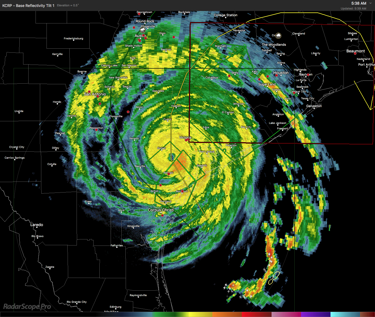
Harvey came ashore around 10 pm last night just northeast of Port Aransas and east-southeast of Rockport. Harvey was upgraded to a category 4 hurricane in the hours just prior to landfall. As you can see in the radar image below, Harvey was centered about 19 miles southwest of Victoria, TX, at the time I grabbed that image. The official NHC track forecast for Harvey is to keep it meandering over the south central coastal area of Texas all the way into the middle of the week.
For us, moisture levels area forecast to come up over the next several days, so today should be dry, but we might see some chance for isolated showers on Sunday. Extensive cloud cover coming out way from Harvey will keep the temperatures in check with highs in the 84 to 87 range.
By Monday, moisture levels have come up enough that we will need to mention chances for showers though those chances will remain low, mainly around 20 percent.
By Tuesday, we have a nice trough aloft over the Central Great Lakes all while the upper low reflecting Harvey continues to meander along the south central coastal area of Texas. Also on Tuesday we could see some development of the weak system over Florida today that will be moving northeast along the Southeast US Coast. This adds a degree of complication to our forecast since that system could be providing some sinking motion to the west of it. MOS guidance suggests 40 percent chance for showers, and with precipitable water values coming up, we’ll need to keep some chance of showers in the forecast. Highs will be in the middle 80s.
The troughiness over the eastern part of the country weakens by Wednesday, and moisture values surge upward with precipitable water values forecast to be around 2 inches. This should produce a favorable environment for numerous showers especially when you add an approaching cold front. With the potential for numerous showers, our highs are likely to stay in the lower 80s.
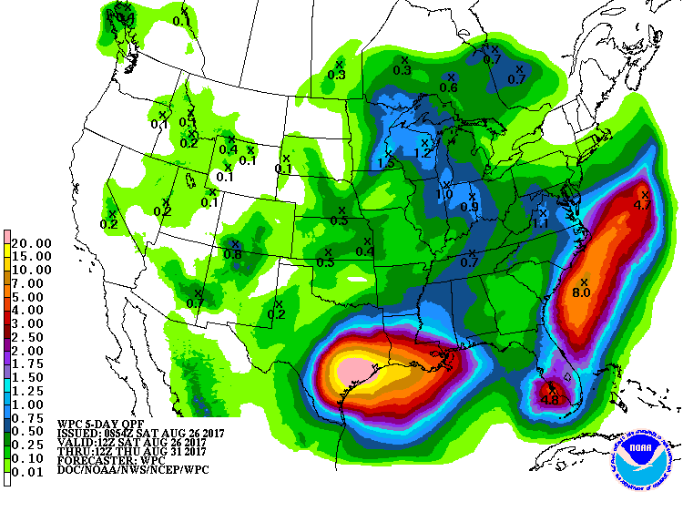
Rainfall for us is likely to be fairly light since the rain will be coming from showers. However, the five day forecast through Thursday morning continued to project upwards of 20 inches over the southeast coastal section of Texas.
Thursday and Friday the troughiness over the eastern part of the country begins to wane some putting an end to the forward motion of the front while keeping moisture levels across the Alabama fairly high. So under this scenario shower chances would remain in the 40 to 60 percent range while temperatures remain in the lower 80s. This scenario is predicated on the GFS having the correct solution with Harvey. Experience tells me that there are two favorable possibilities for Harvey. One is what the GFS suggest as Harvey remains cutoff from the prevailing flow and meanders southwestward eventually filling and dissipating. But experience also says that Harvey could be picked up in the prevailing flow as a short wave moves through the Middle Mississippi River Valley during the latter part of the week. Hurricane Elena was a great example of how strong tropical systems can be influenced by troughs in the prevailing flow well north of the Gulf coast area. The problem, of course, is that neither the ECMWF or the GFS is latching onto this solution, but it is not completely impossible. That is one of the reasons I said earlier in this post, “stay tuned.”
Looking out into voodoo country, the GFS remains locked into the idea of keeping a substantial trough over the eastern US for all of week 2. This keeps us out of any significant heat as we hit September. The GFS is also showing a fairly strong tropical system off the East Coast of the US during this period. This idea is certainly possible since we will be at the peak of hurricane season. The peak comes on September 10th which is right at the end of week 2.
At the beaches of Alabama and Northwest Florida, there will be passing showers for the weekend with highs mainly in the upper 80s. Shower chances ramp up into next week as moisture from Harvey becomes more prevalent across the Southeast US. This will help to keep highs a tad cooler, mainly in the lower 80s. Click here to see the AlabamaWx Beach Forecast Center page. The Beach Forecast is partially underwritten by the support of Brett/Robinson Vacation Rentals in Gulf Shores and Orange Beach. Click here to see Brett/Robinson’s Hot Deals now!
WEATHER BRAINS: Don’t forget you can listen to our weekly 90 minute netcast anytime on the web, or on iTunes. This is the show all about weather featuring many familiar voices, including our meteorologists here at ABC 33/40.
I’ll have the next Weather Xtreme Video posted here by 7 am or so on Sunday morning. Remember, you can always check back here for the latest thinking on Alabama’s weather. Have a great day and Godspeed.
-Brian-
Category: Alabama's Weather, ALL POSTS
About the Author (Author Profile)
Brian Peters is one of the television meteorologists at ABC3340 in Birmingham and a retired NWS Warning Coordination Meteorologist. He handles the weekend Weather Xtreme Videos and forecast discussion and is the Webmaster for the popular WeatherBrains podcast.Subscribe
If you enjoyed this article, subscribe to receive more just like it.


