

Afternoon Thoughts on the Tropics
A few thoughts on the tropics as I get ready to post my afternoon forecast package update. Lots of talk about Irma and where it will go. Perhaps the picture is coming into clearer focus, but no doubt Irma will throw a few surprises before it is done
THE LATEST: Major Hurricane Irma is located some 975 miles due east of the island of Anguilla in the northern Leeward Islands, steaming west at 14 mph. Top winds are still 115 mph, making it a category three hurricane, although the storm appears to be constantly fluctuating in intensity. A strong ridge of high press to the north is steering the storm, like a cork floating in a stream. That stream will start to turn west northwest and eventually northwest in the next couple of days.
AFFECTS ON THE ISLANDS: How far west it goes is of great concern for the islands of the Caribbean and the United States coastline. For now, the official forecast calls for the center to pass within 100 miles of the islands of Antigua and Barbuda, St. Barthelemy, St. Martin and Anguilla. Tropical storm conditions should affect all the islands north of and including Guadaloupe starting Tuesday night, with strong tropical storm force winds arriving Wednesday morning. Hurricane force winds will affect Anguilla by Wednesday afternoon. On the current forecast track, it will also bring strong winds to the Virgin Islands and Puerto Rico.
THREAT TO THE U.S.: It may stay far enough north of Hispaniola to keep its inner core from being shredded. This would mean that it would remain a powerful hurricane as it takes a slightly more northerly track through the islands of the Bahamas starting Friday. By then, the U.S. Southeast Coast from Florida to North Carolina and Virginia will be in full preparation mode for a major hurricane. The morning run of the deterministic GFS is much faster, bringing the hurricane to the South Carolina coast Sunday night into Monday morning the 10th and 11th. Both major global models are in decent agreement on this track.
ENSEMBLE APPROACH: The various members of the American model, the GFS, have the center of the hurricane anywhere from near Jacksonville FL to the northern Outer Banks of North Carolina. The European is very similar, with tracks that lead anywhere from the central Gulf (5%) to the East Coast of Florida (20%) to the Carolinas or Georgia (25%) to 50% that keep it offshore. But trends have been shifting more westward on recent runs, so it does look like parts of the U.S. Southeast coast will deal with a major hurricane next weekend into early the following week.
The GFS is zeroing in on the Georgia/South Carolina coast with its ensemble mean location for the hurricane in eight days on Monday the 11th with separate member outputs from the NE gulf of Mexico to the Outer Banks of North Carolina. Here are the ensemble low pressure centers from the GFS from the 12z run this morning.
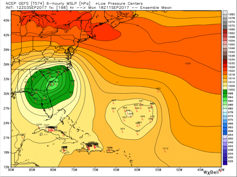
This is by no means a forecast at this time, but is representative of some fairly consistent output from the GFS over the past few runs and is a plausible solution based on a ridge building into the north of the storm in the wake of our next trough.
The control run of the European this morning shows the storm reaching the northwestern Bahamas as a powerful category four hurricane then turning it abruptly north and northeast so it misses the U.S. coastline, a good scenario for the U.S. Its ensemble members show a wider spread than the GFS, with tracks from Louisiana to the Florida Panhandle, to all of the Florida Peninsula to The Carolinas and Georgia to New England. But a large number of the scenario remains off shore.
AFFECTS ON ALABAMA: Unless one of the less likely tracks into the Gulf of Mexico materialize, the effects on Alabama from Irma will be at most brisk northerly winds and dry weather thanks to subsidence or sinking air on the western side of the storm, if it tracks over the Carolinas.
REST OF THE TROPICS: There is another tropical wave some 500 miles southwest of the Cape Verde Islands. This system has a high probability of becoming a tropical cyclone in coming days and should become Tropical Storm or Hurricane Jose. Perhaps not until it approaches the islands late in the week. Where it ends up will be interesting as well, especially if the ridge builds in quickly behind Irma. But for now it appears that Jose will turn northward away from the United States.
CAUTIONARY HISTORICAL NOTE: The Long Island Hurricane of 1821 is the only hurricane to directly strike the area which is currently New York City. The Category 3 hurricane raised the water level at the Battery to thirteen feet above normal sea level on this date in 1821. The East River and Hudson Rivers reportedly merged, inundating Manhattan to Canal Street. A similar storm today is a worst case scenario for preparedness officials. A similar storm striking Manhattan today would result in countless injuries and fatalities. Damage could total $200 Billion. Let’s hope it doesn’t happen with Irma. Some model runs have hinted that is a possibility in the past few days, although a track toward the South Atlantic coast looks more likely.
About the Author (Author Profile)
Bill Murray is the President of The Weather Factory. He is the site's official weather historian and a weekend forecaster. He also anchors the site's severe weather coverage. Bill Murray is the proud holder of National Weather Association Digital Seal #0001 @wxhistorianSubscribe
If you enjoyed this article, subscribe to receive more just like it.


