

Irma Will Bring Wind/Rain To Parts Of Alabama Early Next Week
BEAUTIFUL WEEKEND AHEAD: Not much change in the Alabama weather situation through the weekend. Sunny pleasant days, clear cool nights. Highs in the low 80s, lows between 55 and 60 for most places.
FOOTBALL WEATHER: A perfect night for high school football games tonight; a clear sky with temperatures falling into the 60s.
Alabama will host Fresno State in Tuscaloosa tomorrow afternoon (2:30p CT kickoff)… the sky will be sunny with temperatures falling from near 82 degrees at kickoff to near 78 by the end of the game.
Auburn is on the road; they will take on Clemson in South Carolina tomorrow evening (6:00p CT kickoff)… the sky will be clear with temperatures falling from 77 degrees at kickoff to near 70 by the final whistle. We should note the weather will be dry Sunday for those traveling back to Alabama; any impact from Hurricane Irma in South Carolina will come Monday into Tuesday.
UAB will be in Muncie, Indiana… they play Ball State tomorrow afternoon (2:00p CT kickoff). We are forecasting a clear sky with temperatures in the 68-71 degree range during the game.
WHAT YOU NEED TO KNOW ABOUT HURRICANE IRMA…
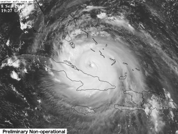
Irma has been moving toward the west near 14 mph, but the hurricane should resume a west-northwest motion later today. A turn toward the northwest is expected by late Saturday. On the forecast track, the eye of Irma should continue to move near the north coast of Cuba and the central Bahamas for the rest of today and Saturday, and be near the Florida Keys and the southern Florida Peninsula Sunday morning.
Maximum sustained winds are near 155 mph with higher gusts. Irma is a category 4 hurricane on the Saffir-Simpson Hurricane Wind Scale. Some fluctuations in intensity are likely to continue during the next day or two, and Irma is expected to remain a powerful category 4 hurricane as it approaches Florida.
Hurricane-force winds extend outward up to 70 miles from the center and tropical-storm-force winds extend outward up to 185 miles. The latest minimum central pressure reported by an Air Force
reconnaissance plane was 925 mb (27.31 inches).
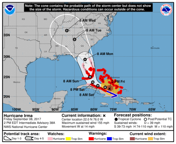
Everyone in the Florida Peninsula will need to be ready for hurricane conditions Sunday. While the most serious storm surge flooding and widespread wind damage will most likely be on the Atlantic coast, there is potential for structural damage and widespread power outages on the West Coast (Tampa, St. Petersburg, Sarasota, Fort Myers, Naples, etc) as well. Hurricane force winds are likely in Orlando Sunday. This is a very dangerous storm and must be taken seriously. Evacuation orders must be heeded NOW.
Projected impacts…
FLORIDA PANHANDLE/ALABAMA COAST: While it will be windy Sunday and Monday (a north, offshore wind), places like Gulf Shores, Pensacola, Navarre Beach, and Destin should be dry. Winds will be higher at Panama City Beach Monday, in the 25-40 mph range, with some rain possible, but the main impact of Irma will remain to the east. Winds will diminish Tuesday along the coast and the weather looks great for the rest of the week. If I had a vacation trip planned to Panama City Beach, I would go without hesitation.
ALABAMA: The circulation center of Irma is expected to move through North Georgia, and perhaps through the northeast tip of Alabama Tuesday as a tropical depression. We will remain on the “good” west side, but it will be windy with rain at times Monday afternoon through Tuesday morning over the northern and eastern counties of the state. Rain amounts of 1-3″ are likely (heavier totals will be near the Georgia border), and winds over the eastern half of the state will be in the 25-35 mph range, with occasional higher gusts, especially on ridgetops. We don’t expect any flooding issues, and there is no risk of tornadoes in our state (the tornado risk will over parts of Georgia and the Carolinas). Southwest Alabama (the broad area from Demopolis down to Mobile) will see no rain at all.
GEORGIA/SOUTH CAROLINA: Atlanta could see winds in the 35-45 mph range late Monday night and Tuesday as the circulation center passes pretty much over the city; there could be some trees blown down and scattered power outages, but noting widespread is expected. A few isolated tornadoes are possible Tuesday over Central and East Georgia and South Carolina.
Lots of wind and rain for the Georgia and lower South Carolina coast Monday, but Irma will not make a landfall on the the coast there based on the latest NHC forecast.
REMEMBER: There is a flood of weather information floating around social media… some good, some really bad. Stick with a reliable source, or the official products from NHC. And, if you are using a forecast that is more than six hours old, it is bad information. Use the most current update.
NOTE: Florida residents coming into Alabama, if you’re looking for information, you call 211 or 888-421-1266.
KATIA: This is the hurricane in the far Southwest Gulf of Mexico; it will move into Mexico tonight with sustained winds of 105 mph.
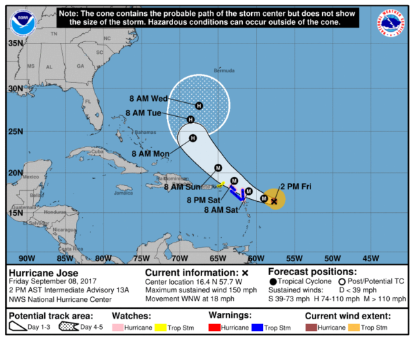
JOSE: The hurricane east of Irma is now a major, category four hurricane with sustained winds of 150 mph. It will gain latitude and basically go nowhere over the next five days. Too early to call the final destination.
WEATHER BRAINS: Don’t forget you can listen to our weekly 90 minute netcast anytime on the web, or on iTunes. This is the show all about weather featuring many familiar voices, including our meteorologists here at ABC 33/40.
CONNECT: You can find me on all of the major social networks…
Facebook
Twitter
Google Plus
Instagram
Pinterest
Snapchat: spannwx
Look for the next Weather Xtreme video here Monday morning by 7:00 a.m…. Brian Peters will have the video updates tomorrow and Sunday. Enjoy the weekend!
Category: Alabama's Weather, ALL POSTS, Weather Xtreme Videos
About the Author (Author Profile)
James Spann is one of the most recognized and trusted television meteorologists in the industry. He holds the AMS CCM designation and television seals from the AMS and NWA. He is a past winner of the Broadcast Meteorologist of the Year from both professional organizations.Subscribe
If you enjoyed this article, subscribe to receive more just like it.


