

Wet/Windy Tonight; Improving Weather Tomorrow
**No afternoon Weather Xtreme video today due to our coverage on ABC 33/40**
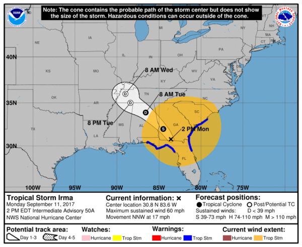
COLD, WET, WINDY: This sure doesn’t feel like a September day. Temperatures are only in the 50s over much of North and East Alabama with a soaking rain and strong north wind on the west side of the circulation of Tropical Storm Irma over Southwest Georgia.
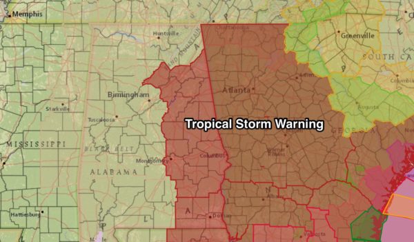
Tree damage has already been reported in many East Alabama counties, where winds are now averaging 25-35 mph. Wind speeds will continue to ramp up through tonight. A tropical storm warning is in effect for much of East and Southeast Alabama, with a wind advisory for the rest of the state.
IMPACT TONIGHT: This is what you can expect across Alabama tonight…
*Winds over East Alabama, in the tropical storm warning, will be 35-45 mph range through tonight with higher gusts on ridges. Trees will be blown down in scattered spots, and some power outages are likely.
*On the western side of the state, winds of 20-30 mph are likely tonight with occasionally higher gusts.
*Rain amounts of 2-4″ are possible over East Alabama, with 1-3″ for the rest of the state between now and early tomorrow morning. Major flooding issues are not expected.
*There is no tornado risk for any part of Alabama. The air is cold, and stable. The tornado threat is far to the east along the coast of Georgia and South Carolina.
*For the Gulf Coast today, a brisk north wind for Gulf Shores, Pensacola, Destin, and Panama City, but no real issues as a result of Irma. In fact, the sun is shining brightly in many coastal communities this afternoon.
TOMORROW: As Irma continues to weaken and lift northward, the weather will improve. Wind will die down tomorrow, and by afternoon they will veer to the south, averaging 10-18 mph. Clouds will linger much of the day, and we will maintain the chance of showers, but nothing like the widespread rain today. The high tomorrow will be in the mid to upper 60s; the average high for September 12 in Birmingham is 87.
WEDNESDAY THROUGH FRIDAY: A warming trend begins; we reach the low 70s Wednesday, low 80s Thursday, and mid 80s Friday. We will hang on to some risk of scattered showers Wednesday and Thursday with a mix of sun and clouds… then Friday should be dry with ample sunshine as an upper ridge begins to build across the region.
THE ALABAMA WEEKEND: Sunny warm days and fair nights Saturday and Sunday with highs in the mid to upper 80s… back to seasonal levels for September in Alabama. Lows over the weekend will be in the 60s.
NEXT WEEK: At least the first half of the week will be warm and dry as the upper ridge holds; highs in the upper 80s Monday and Tuesday.
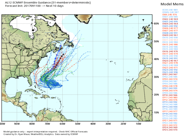
HURRICANE JOSE: Jose is packing sustained winds of 105 mph, and is well north of Puerto Rico. It is expected to do a full loop in the Atlantic over the next five days. The mean of the Euro (ECMWF) ensemble keeps the system offshore this weekend, but it is early in the game and things could change.
BEACH FORECAST: Click here to see the AlabamaWx Beach Forecast Center page. The Beach Forecast is partially underwritten by the support of Brett/Robinson Vacation Rentals in Gulf Shores and Orange Beach. Click here to see Brett/Robinson’s Hot Deals now!
WEATHER BRAINS: Don’t forget you can listen to our weekly 90 minute netcast anytime on the web, or on iTunes. This is the show all about weather featuring many familiar voices, including our meteorologists here at ABC 33/40. We will produce this week’s show tomorrow night.
CONNECT: You can find me on all of the major social networks…
Facebook
Twitter
Google Plus
Instagram
Pinterest
Snapchat: spannwx
Look for the next Weather Xtreme video here by 7:00 a.m. tomorrow…
Category: Alabama's Weather, ALL POSTS
About the Author (Author Profile)
James Spann is one of the most recognized and trusted television meteorologists in the industry. He holds the AMS CCM designation and television seals from the AMS and NWA. He is a past winner of the Broadcast Meteorologist of the Year from both professional organizations.Subscribe
If you enjoyed this article, subscribe to receive more just like it.


