

Clouds Linger; Some Light Rain
IRMA CONTINUES TO FADE: Irma basically is dissipating over Northwest Alabama early this morning; we still have some rain falling near the circulation center.
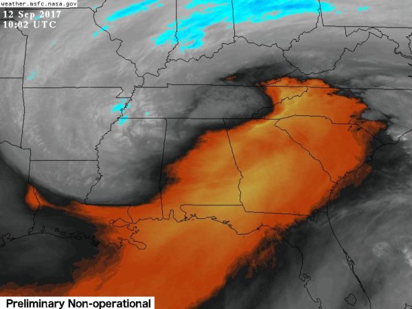
Clouds will linger across the northern half of Alabama much of the day today with some patchy light rain, but nothing too heavy or widespread. And, the southern counties will see a pretty decent amount of sun with only isolated showers. Still a bit breezy… winds today will veer back around to the south by afternoon, averaging 10-18 mph.
Temperatures will remain well below average with a high in the upper 60s today. Yesterday’s official high in Birmingham was 66, a record low maximum for September 11. In fact, while the rain was falling during the afternoon temperatures were only in the 50s, feeling more like January. We should also mention Birmingham’s official rain total was 1.69″, also a daily record for 9/11.
Other rain totals yesterday included 2.79″ at Heflin, 2.63″ at Weaver, 2.15″ at Rainbow City, 1.71″ at Mountain Brook, 1.98″ at Moody, and 1.52″ at Concord.
TOMORROW THROUGH FRIDAY: Tomorrow will be a day with more clouds than sun, and we will hang on to the chance of scattered showers with a high in the low 70s. Thursday and Friday will be warmer with afternoon temperatures going back into the mid 80s; looks like we will enjoy a good supply of sunshine both days with only isolated showers. Many communities will be dry on these two days.
THE ALABAMA WEEKEND: The latest GFS run hints that there could be enough moisture to insert some risk of scattered showers in the forecast, but with a building upper ridge it still looks like most of Saturday and Sunday will be warm and dry. Any showers should be few and far between, and highs should be up in the mid to upper 80s, where we should be in mid-September. Remember, it can get pretty hot this time of the year… Birmingham has experienced triple digit heat as late as September 22 when the high was 100 degrees in 1925.
NEXT WEEK: The upper ridge holds, meaning warm and mostly dry weather for at least the first half of the week with high in the 80s.
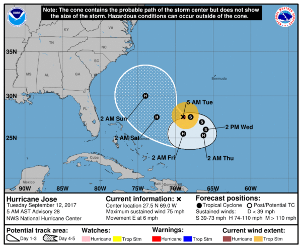
JOSE: This is a minimal hurricane in the Atlantic well north of Puerto Rico, and well east of the Bahamas. It is expected to weaken into a tropical storm later today as it makes a loop across the open Atlantic. But, it is forecast to restrengthen into a hurricane later this week as it moves northeast, parallel to the U.S. East Coast. For now, most global model guidance is suggesting it remains offshore, but still too early to call a final destination.
Another wave in the eastern Atlantic is expected to turn north and remain far from land. See the Weather Xtreme video for maps, graphics, and more details.
ON THIS DATE IN 1979: Frederic made landfall on the Alabama Gulf Coast passing over Dauphin Island and crossed the coastline near the Alabama/Mississippi border. A wind gust of 145 miles per hour was measured on equipment atop the Dauphin Island Bridge. The bridge was destroyed. A wind gust of 139 mph was measured at the Dauphin Island Sea Lab before the equipment failed. A storm surge of 12 feet was observed in Gulf Shores. Nearly all structures within 200 yards of the Alabama coast were destroyed. Total damages were 2.3 billion dollars, making Frederic the most expensive hurricane ever to strike the United States up to that point.
BEACH FORECAST: Click here to see the AlabamaWx Beach Forecast Center page. The Beach Forecast is partially underwritten by the support of Brett/Robinson Vacation Rentals in Gulf Shores and Orange Beach. Click here to see Brett/Robinson’s Hot Deals now!
WEATHER BRAINS: Don’t forget you can listen to our weekly 90 minute netcast anytime on the web, or on iTunes. This is the show all about weather featuring many familiar voices, including our meteorologists here at ABC 33/40. We will produce this week’s show tonight at 8:30p CT… you can watch it live here.
CONNECT: You can find me on all of the major social networks…
Facebook
Twitter
Google Plus
Instagram
Pinterest
Snapchat: spannwx
Look for the next Weather Xtreme video here by 4:00 this afternoon… enjoy the day!
Category: Alabama's Weather, ALL POSTS, Weather Xtreme Videos
About the Author (Author Profile)
James Spann is one of the most recognized and trusted television meteorologists in the industry. He holds the AMS CCM designation and television seals from the AMS and NWA. He is a past winner of the Broadcast Meteorologist of the Year from both professional organizations.Subscribe
If you enjoyed this article, subscribe to receive more just like it.


