

A Few Showers Remain At Midday, But Drier & Warmer Air Expected Tomorrow
RADAR CHECK AT 12:20 PM
Much of Central Alabama is dry at this point as we have arrived to the midday hour, but there are still a few pesky scattered light showers out from the remnants of Irma. The northern half of the area is also dealing with cloud cover from Irma, but the southern half now enjoys mostly clear skies and warmer temperatures.
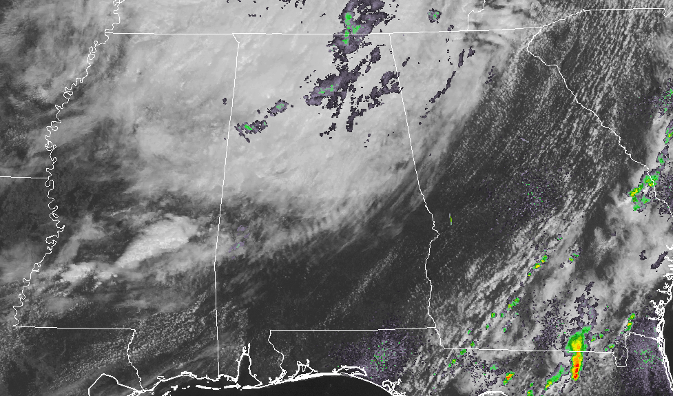
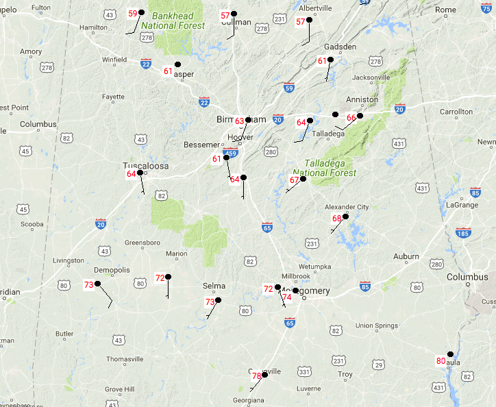
Speaking of temperatures, we have a wide range of temperatures at this times. In the northern parts of the area, it’s in the upper 50s to the lower 60s, while the southern half is in the mid 60s to 80 degrees. Birmingham is currently at 63 degrees, and if this keeps up, we may break the record low maximum for the 3rd day in the row. The old record is at 68 degrees set back in 1959.
REST OF THE DAY
We’ll continue to have a few scattered light showers or sprinkles over the northern half of the state along with cloudy skies, while the southern half will enjoy clearing skies and warmer temperatures. Daytime highs are expected to be in the upper 60s to the mid-80s throughout Central Alabama. Birmingham’s high was expected to be around 72, but the latest HRRR maximum temperature is showing only 66 degrees. That could be very possible, and that would break the old record for lowest maximum temperature for this date. Rain will be coming to an end and skies will begin the clearing process throughout the late night and overnight hours. Overnight lows will be in the upper 50s to the lower 60s.
THURSDAY’S WEATHER
We’ll have partly to mostly sunny skies throughout the area as the remnants from Irma will have finally left the Central Alabama Area. Temperatures will be much warmer as well, with highs reaching the lower to mid-80s throughout the area.
LATEST ON HURRICANE JOSE
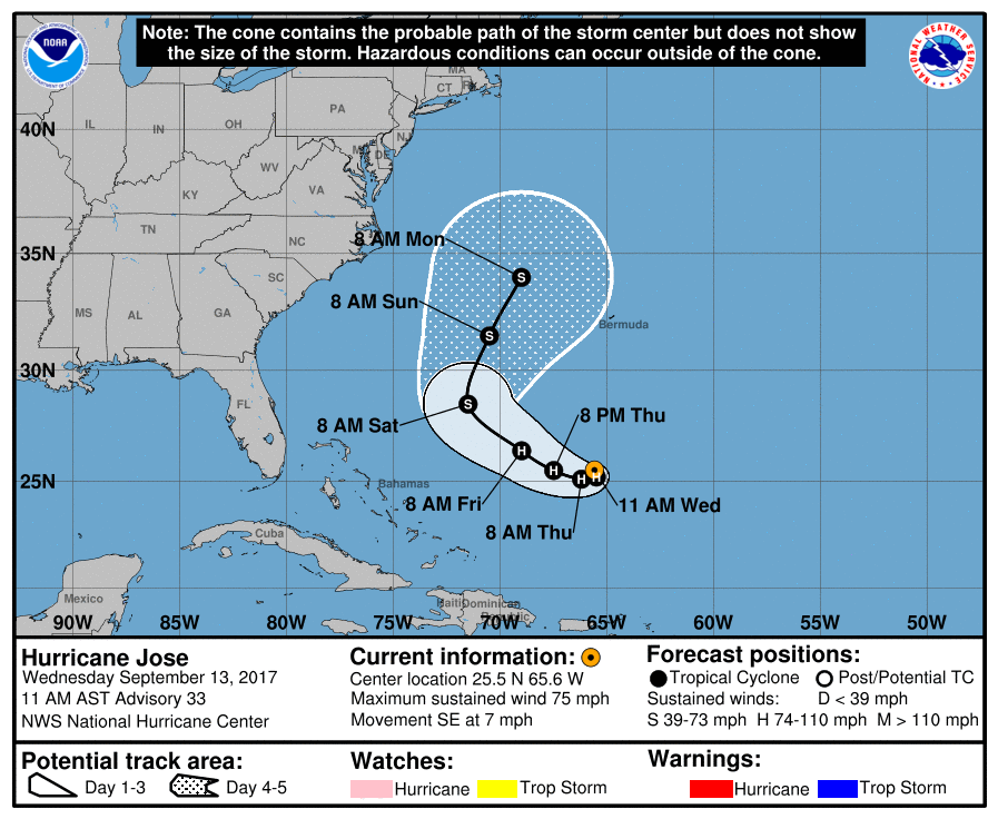
At 10:00 AM, maximum sustained speeds are down to 75 MPH which makes Jose a minimum hurricane. Jose is currently moving to the southwest but is forecast to make a loop and move north-northeastward out to sea. Little change in Jose’s strength is expected for the next day or so, then weakening to a tropical storm. No threat to the US mainland at this point.
OUR TROPICAL WEATHER CATEGORY HAS THE LATEST ON ALL ACTIVE STORMS
Stay up-to-date with the latest updates on all of the tropical systems out in the Atlantic Ocean, Caribbean Sea, or in the Gulf of Mexico with the latest posts in our Tropical Weather section. Click here to see the latest.
GOT BEACH PLANS?
Be sure to keep up to date with the detailed forecasts from Fort Morgan over to Panama City Beach with the AlabamaWx Weather Blog. Click here to see the AlabamaWx Beach Forecast Center page.
The Beach Forecast is partially underwritten by the support of Brett/Robinson Vacation Rentals in Gulf Shores and Orange Beach. Click here to see Brett/Robinson’s Hot Deals now!
ADVERTISE WITH ALABAMAWX
Now is the time to set your marketing campaign on AlabamaWX. The site has enjoyed a 71% jump in page views this year! The website has already enjoyed over 12 MILLION page views this year. We can customize a creative, flexible and affordable package that will suit your organization’s needs. Contact Bill Murray at (205) 687-0782.
E-FORECAST
Get the AlabamaWx seven-day forecast delivered directly to your inbox by email twice daily. It is the most detailed weather forecast available in Central Alabama. Click here to subscribe. It’s free!
ON THIS DAY IN WEATHER HISTORY
1988 – Hurricane Gilbert smashed into the Cayman Islands, and as it headed for the Yucatan peninsula of Mexico strenghtened into a monster hurricane, packing winds of 175 mph. The barometric pressure at the center of Gilbert reached 26.13 inches (888 mb), an all-time record for any hurricane in the Carribean, Gulf of Mexico, or the Atlantic Ocean. Gilbert covered much of the Gulf of Mexico, producing rain as far away as the Florida Keys.
WEATHERBRAINS
Check out the show at www.WeatherBrains.com. You can also subscribe on iTunes. You can watch the show live at live.bigbrainsmedia.com on Monday nights starting at 8:30 PM CDT. You will be able to see the show on the James Spann 24×7 weather channel on cable or directly over the air on the dot 2 feed.
Category: Alabama's Weather, ALL POSTS
About the Author (Author Profile)
Scott Martin is an operational meteorologist, professional graphic artist, musician, husband, and father. Not only is Scott a member of the National Weather Association, but he is also the Central Alabama Chapter of the NWA president. Scott is also the co-founder of Racecast Weather, which provides forecasts for many racing series across the USA. He also supplies forecasts for the BassMaster Elite Series events including the BassMaster Classic.Subscribe
If you enjoyed this article, subscribe to receive more just like it.


