

Warmer, Brighter Days Ahead
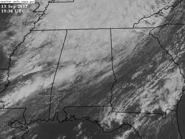
ANOTHER RECORD LOW MAXIMUM POSSIBLE: Birmingham reports 66 degrees at 3:00… a decent chance we establish a record low maximum temperature for the third day in a row. The current “record low high” for September 13 is 68 set in 1959. Clouds cover the northern half of the state, and we still are seeing some patches of light rain on radar.
In contrast, the southern half of Alabama is dry and warm with temperatures in the low 80s.
TOMORROW THROUGH THE WEEKEND: We have a pattern change coming. The circulation over the eastern U.S. (formerly known as Hurricane Irma) will weaken and lift out, and an upper ridge will develop. And, to the west, a cold upper trough will develop over the western U.S. Our friends in western Montana are under a winter storm watch for the first time this season.
Here in Alabama we project partly to mostly sunny, warm days, and fair nights tomorrow through Sunday with only isolated showers during the afternoon and evening hours. Most communities will be dry. We rise into the low 80s tomorrow, mid 80s Friday, and upper 80s Saturday and Sunday.
FOOTBALL WEATHER: Looking good for high school games Friday night; mostly fair with temperatures falling from near 78 at kickoff into the low 70s by the fourth quarter.
Auburn hosts Mercer Saturday afternoon (3:00p CT kickoff)… we project a party sunny sky with only a small risk of a shower during the game. Temperatures near 87 at kickoff, falling into the upper 70s by the final whistle.
UAB also has an afternoon game; they host Coastal Carolina (12:00 noon CT kickoff) at Birmingham’s Legion Field. Temperature near 83 at kickoff, rising to near 88 by the fourth quarter. Partly sunny, just a small risk of a shower.
And, Alabama hosts the Colorado State Rams at Bryant Denny Stadium Saturday evening (6:00p CT kickoff)… mostly fair with temperatures falling from the mid 80s at kickoff into the upper 70s by the second half.
NEXT WEEK: The upper air pattern stays the same. Ridge in the east, cold through in the west. For Alabama, the week looks generally dry and warm with highs in the 80s.
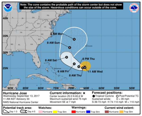
JOSE STILL A HURRICANE: Jose is packing sustained winds of 75 mph, and is in the Atlantic well north of Puerto Rico and east of the Bahamas. It will turn north, then northeast over the next five days and the official NHC forecast keeps it well east of the U.S.
The rest of the Atlantic basin is quiet.
BEACH FORECAST: Click here to see the AlabamaWx Beach Forecast Center page. The Beach Forecast is partially underwritten by the support of Brett/Robinson Vacation Rentals in Gulf Shores and Orange Beach. Click here to see Brett/Robinson’s Hot Deals now!
WEATHER BRAINS: Don’t forget you can listen to our weekly 90 minute netcast anytime on the web, or on iTunes. This is the show all about weather featuring many familiar voices, including our meteorologists here at ABC 33/40.
CONNECT: You can find me on all of the major social networks…
Facebook
Twitter
Google Plus
Instagram
Pinterest
Snapchat: spannwx
Look for the next Weather Xtreme video here by 7:00 a.m. tomorrow…
Category: Alabama's Weather, ALL POSTS, Weather Xtreme Videos
About the Author (Author Profile)
James Spann is one of the most recognized and trusted television meteorologists in the industry. He holds the AMS CCM designation and television seals from the AMS and NWA. He is a past winner of the Broadcast Meteorologist of the Year from both professional organizations.Subscribe
If you enjoyed this article, subscribe to receive more just like it.


