

A Few Isolated Showers Out There At Midday, Still Feels Like Summer
RADAR CHECK AT 11:30 AM
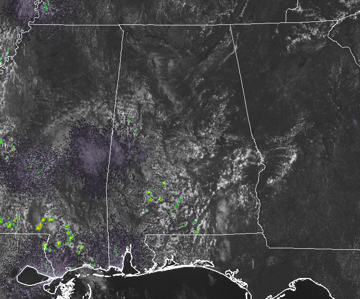
With Birmingham Radar being down for technical repairs at the moment, we have to look around the state with the nearest radar sites to the Birmingham area. As I took my gander around the area, a few isolated shows have popped up over in the western part of the state in Pickens and Greene counties. There are a few scattered showers to the south mainly below Central Alabama, but one has popped up in west-central Lowndes County. The rest of Central Alabama is dry at this point.
TEMPERATURES AT 11:30 AM
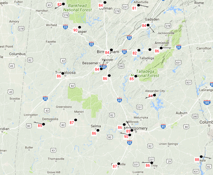
Central Alabama is currently ranging from the lower 80s in the north to the upper 80s in the south. Birmingham was at 84 degrees, while Eufaula is the warm spot at 88 degrees.
REST OF THE DAY
We’ll continue to have mostly clear to partly cloudy skies across Central Alabama throughout the remainder of the daylight hours, with a slight chance of an isolated shower, mainly along and west of the I-65 corridor. Highs will reach the upper 80s to the lower 90s throughout the area. Rain chances diminish for the evening and overnight hours but we could have one or two showers hang on for a little while. Overnight lows will be in the mid-60s to the lower 70s.
TUESDAY’S WEATHER KEEPS UP VERY WARM WITH SOME SHOWERS
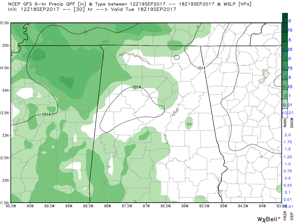
Another very warm and humid day across Central Alabama with partly cloudy skies. Highs will once again make it up into the mid-80s to the lower 90s. We’ll have a slight chance of isolated showers in the central 1/3rd of the area, with scattered showers possible in the western 1/3rd of the area mainly along and just east of the AL/MS state line. The eastern part of the area will remain dry.
HURRICANE JOSE
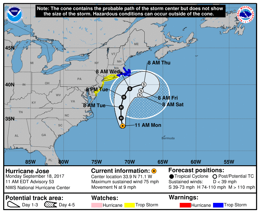
As of the 10:00 AM advisory from the National Hurricane Center, Jose is still packing maximum sustained winds at 75 MPH and is moving to the north at 9 MPH. The latest forecast track has Jose starting to curve back out to sea on Tuesday evening, but will come very close to the shoreline of Massachussetts and Rhode Island. Therefore, tropical storm warnings have been issued from the Connecticut/Rhode Island state line around to near Boston, while tropical storm watches are up south of the warning to the Delaware/Maryland state line. Dangerous surf and rip currents can be expected, along with up to 5 inches of rain over parts of Long Island, southeast Connecticut, southern Rhode Island, and southeast Massachussetts. Tropical storm winds are possible beginning on Tuesday.
HURRICANE MARIA
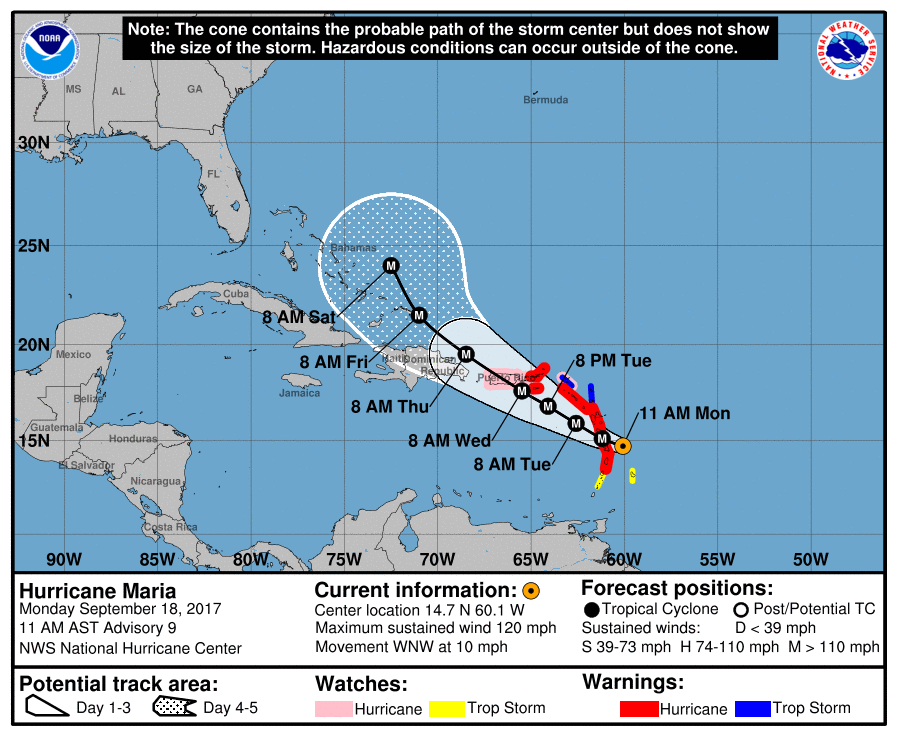
As feared, Maria has now reached major hurricane status with maximum sustained winds of 120 MPH, making her a category 3 storm. Movement is to the west-northwest at 10 MPH, and the center will soon be moving over parts of the Leeward Islands later today. Rapid intensification is expected during the next two days as it moves across Puerto Rico on Wednesday morning, and comes close to the Dominican Republic on Thursday. There is a northerly turn in its forecast track before it reaches the Bahamas, but where it goes from there we will have to wait and see. Guidance models have Maria turning north before reaching the US Mainland, but a few members have her moving very close to the Carolinas and Virginia. Still too early to tell exactly where she will go, but we’ll keep our eyes on her.
TROPICAL DEPRESSION LEE
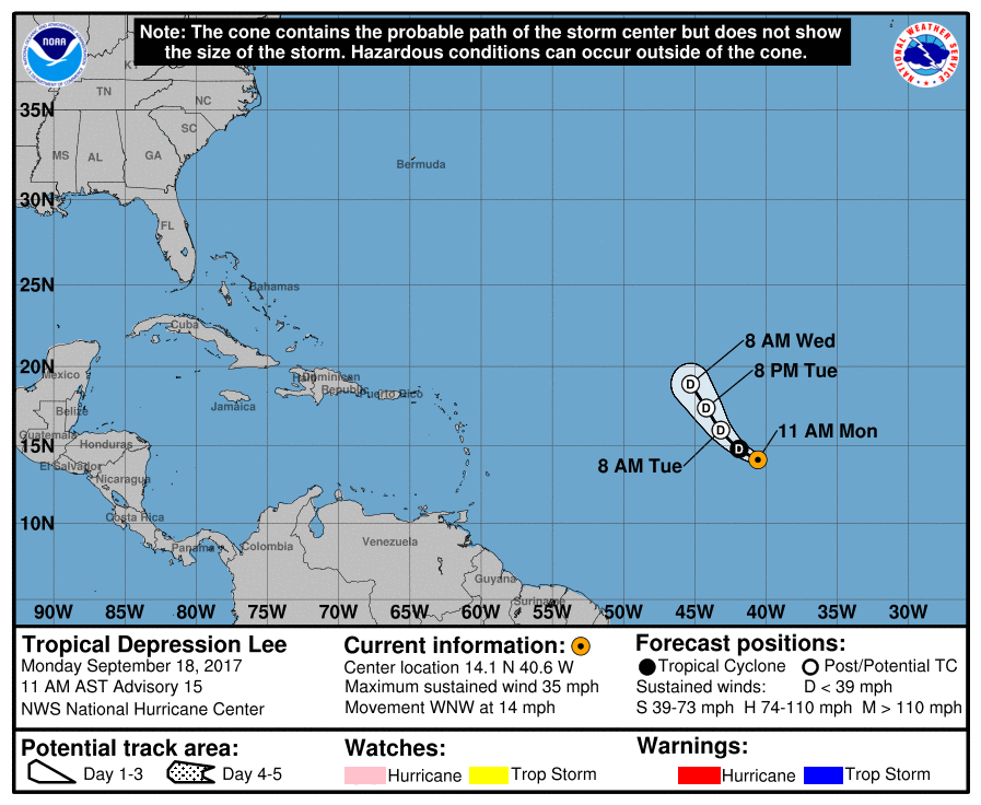
Lee continues to hold on by a thread at this point. Lee is currently no threat to any land, and its forecast path continues on a northeastward direction at 14 MPH. Lee is forecast to degenerate into a remnant low sometime tonight or in the early morning hours on Tuesday.
OUR TROPICAL WEATHER CATEGORY HAS THE LATEST ON ALL ACTIVE STORMS
Stay up-to-date with the latest updates on all of the tropical systems out in the Atlantic Ocean, Caribbean Sea, or in the Gulf of Mexico with the latest posts in our Tropical Weather section. Click here to see the latest.
GOT BEACH PLANS?
Be sure to keep up to date with the detailed forecasts from Fort Morgan over to Panama City Beach with the AlabamaWx Weather Blog. Click here to see the AlabamaWx Beach Forecast Center page.
The Beach Forecast is partially underwritten by the support of Brett/Robinson Vacation Rentals in Gulf Shores and Orange Beach. Click here to see Brett/Robinson’s Hot Deals now!
ADVERTISE WITH ALABAMAWX
Now is the time to set your marketing campaign on AlabamaWX. The site has enjoyed a 71% jump in page views this year! The website has already enjoyed over 12 MILLION page views this year. We can customize a creative, flexible and affordable package that will suit your organization’s needs. Contact Bill Murray at (205) 687-0782.
E-FORECAST
Get the AlabamaWx seven-day forecast delivered directly to your inbox by email twice daily. It is the most detailed weather forecast available in Central Alabama. Click here to subscribe. It’s free!
ON THIS DAY IN WEATHER HISTORY
1926 – The great “Miami Hurricane” produced winds reaching 138 mph which drove ocean waters into the Biscayne Bay drowning 135 persons. The eye of the hurricane passed over Miami, at which time the barometric pressure reached 27.61 inches. Tides up to twelve feet high accompanied the hurricane, which claimed a total of 372 lives.
WEATHERBRAINS
Check out the show at www.WeatherBrains.com. You can also subscribe on iTunes. You can watch the show live at live.bigbrainsmedia.com on Monday nights starting at 8:30 PM CDT. You will be able to see the show on the James Spann 24×7 weather channel on cable or directly over the air on the dot 2 feed.
Category: Alabama's Weather, ALL POSTS
About the Author (Author Profile)
Scott Martin is an operational meteorologist, professional graphic artist, musician, husband, and father. Not only is Scott a member of the National Weather Association, but he is also the Central Alabama Chapter of the NWA president. Scott is also the co-founder of Racecast Weather, which provides forecasts for many racing series across the USA. He also supplies forecasts for the BassMaster Elite Series events including the BassMaster Classic.Subscribe
If you enjoyed this article, subscribe to receive more just like it.


