

Warm; A Few Scattered Showers… Eyes On Jose/Maria
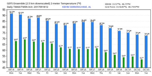
RADAR CHECK: As expected, showers are almost impossible to find across the northern half of Alabama this afternoon. We are seeing just a few isolated showers over the central counties moving to the south; those will dissipate once the sun goes down. Temperatures are well in the 80s, and Tuscaloosa has hit 91 degrees this afternoon. The average high for September 18 (based on data from Birmingham) is 85 degrees.
REST OF THE WEEK: The weather stays warm with highs mostly in the mid to upper 80s. Showers will remain widely spaced tomorrow, but should show an increase in coverage Wednesday through Friday as moisture levels rise. Still, they will be random and scattered, and mostly during the afternoon and evening hours. Pretty typical late summer/early fall weather in Alabama.
EQUINOX: We should note here that fall will “officially” begin Friday afternoon (September 22) at 3:02p CT, when the sun is directly over the equator.
THE ALABAMA WEEKEND: Not much change. Warm, humid weather continues Saturday and Sunday with some risk of “scattered, mostly afternoon and evening showers and thunderstorms”. Highs will be mostly in the mid 80s. The GFS does hint that showers could be fewer in number Sunday, as we get into the subsidence ring of sinking air on the periphery of Hurricane Maria, but there is great uncertainty in that idea.
And, we will roll with a persistence forecast through at least the first half of next week. See the Weather Xtreme video for maps, graphics, and details.
TOPIC: TROPICS: Lee is a weakening tropical depression in the Central Atlantic; it should become a remnant low tonight. Jose and Maria are the issues to talk about today…
JOSE: Jose is now a minimal hurricane with sustained winds of 75 mph about 265 miles east/southeast of Cape Hatteras. The center will remain offshore, but it will be close enough to bring tropical storm force winds to parts of the upper Atlantic coast; a tropical storm warning is in effect for…
* Watch Hill to Hull
* Block Island
* Martha’s Vineyard
* Nantucket

Jose is expected to lose tropical characteristics late this week as it begins to make a loop east of New England. There is a chance, if the circulation hangs on, it could interact with Hurricane Maria coming up from the south by the weekend or early next week. Some potential for the Fujiwhara effect… a case where they would orbit cyclonically (counterclockwise) about a point between the two systems.
MARIA: The hurricane has been going through a rapidly deepening phase today. It now is packing sustained winds of 130 mph, a dangerous category four hurricane, and could very well be stronger by the time you read this. The eye is only 40 miles east/northeast of Martinique.
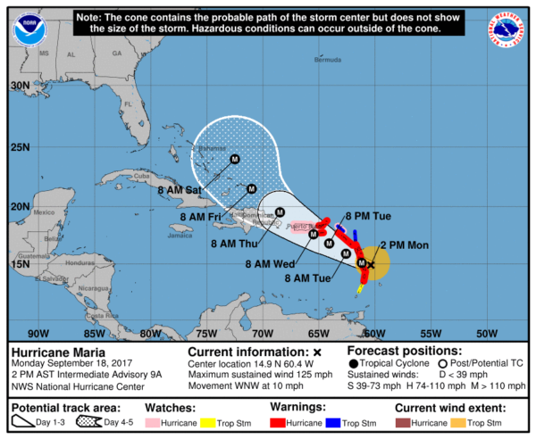
A Hurricane Warning is in effect for…
* Guadeloupe
* Dominica
* St. Kitts, Nevis, and Montserrat
* Martinique
* U.S. Virgin Islands
* British Virgin Islands
* Puerto Rico, Culebra, and Vieques
Maria is forecast to pass right over Puerto Rico Wednesday, then moving north of Hispaniola as it begins to gain latitude. It is still too early to know if Maria will impact the East Coast of the U.S. Confidence is very high that Maria will not enter the Gulf of Mexico.
BEACH FORECAST: Click here to see the AlabamaWx Beach Forecast Center page. The Beach Forecast is partially underwritten by the support of Brett/Robinson Vacation Rentals in Gulf Shores and Orange Beach. Click here to see Brett/Robinson’s Hot Deals now!
WEATHER BRAINS: Don’t forget you can listen to our weekly 90 minute netcast anytime on the web, or on iTunes. This is the show all about weather featuring many familiar voices, including our meteorologists here at ABC 33/40. We will produce this week’s show tonight at 8:30p CT… you can watch it live here.
CONNECT: You can find me on all of the major social networks…
Facebook
Twitter
Google Plus
Instagram
Pinterest
Snapchat: spannwx
I had a great time today visiting with the 3rd graders at Deer Valley Elementary… be looking for them on the Pepsi KIDCAM today at 5:00 on ABC 33/40 News! The next Weather Xtreme video will be posted here by 7:00 a.m. tomorrow…
Category: Alabama's Weather, ALL POSTS, Weather Xtreme Videos
About the Author (Author Profile)
James Spann is one of the most recognized and trusted television meteorologists in the industry. He holds the AMS CCM designation and television seals from the AMS and NWA. He is a past winner of the Broadcast Meteorologist of the Year from both professional organizations.Subscribe
If you enjoyed this article, subscribe to receive more just like it.


