

Mostly Dry This Week; Cooler Air By Friday
RADAR CHECK: We have rain this morning over parts of West/Central Alabama… some in Sumter and Choctaw Counties are getting wet as the sun comes up.
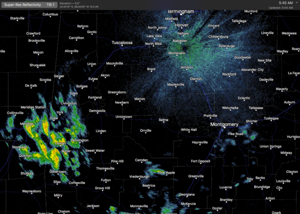
While the best chance of showers will come over the southern half of the state today, a few are possible across North/Central Alabama, but they will be widely separated. Otherwise, today will be partly sunny with a high in the mid to upper 80s.
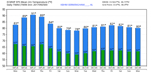
MID-WEEK: We project warm, dry weather tomorrow through Thursday. A northerly flow on the far west side of the circulation of Hurricane Maria will limit any moisture return; the sky will be mostly sunny with highs in the 87-90 degree range tomorrow and Wednesday, followed by mid 80s Thursday. Morning lows will be in the 60s.
FRIDAY AND THE WEEKEND: The upper ridge begins to break down, and we will enjoy cooler air as temperatures get back to average levels for late September and early October. Mostly sunny days, fair nights with highs between 78 and 81, and lows in the upper 50s and low 60s. Cooler pockets will see lows down in the low to mid 50s.
NEXT WEEK: We stay dry early in the week; global models suggest some rain could return to the state by Wednesday. Keep in mind we are now in the driest part the year in our state (late September through October). Then, we enter our late fall severe weather season in November/December.
TROPICS: Hurricane Lee is a compact system in the Central Atlantic nearly stationary; it is expected to remain far from land and ultimately kick out to the northeast in a few days.
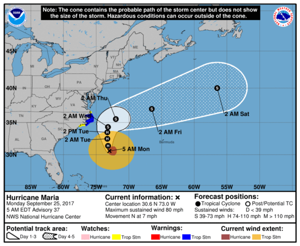
Hurricane Maria, now with sustained winds of 80 mph, will remain offshore, but it is close enough to warrant a tropical storm warning for the North Carolina Outer Banks, where winds could exceed 39 mph at times tomorrow and Wednesday. It will move east/northeast, away from the coast, later this week.
The rest of the Atlantic basin, including the Gulf of Mexico, is very quiet.
BEACH FORECAST: Click here to see the AlabamaWx Beach Forecast Center page. The Beach Forecast is partially underwritten by the support of Brett/Robinson Vacation Rentals in Gulf Shores and Orange Beach. Click here to see Brett/Robinson’s Hot Deals now!
WEATHER BRAINS: Don’t forget you can listen to our weekly 90 minute netcast anytime on the web, or on iTunes. This is the show all about weather featuring many familiar voices, including our meteorologists here at ABC 33/40.
CONNECT: You can find me on all of the major social networks…
Facebook
Twitter
Google Plus
Instagram
Pinterest
Snapchat: spannwx
I will be doing a weather program this morning in Pickens County… look for the next Weather Xtreme video here by 4:00 this afternoon… enjoy the day!
Category: Alabama's Weather, ALL POSTS, Weather Xtreme Videos
About the Author (Author Profile)
James Spann is one of the most recognized and trusted television meteorologists in the industry. He holds the AMS CCM designation and television seals from the AMS and NWA. He is a past winner of the Broadcast Meteorologist of the Year from both professional organizations.Subscribe
If you enjoyed this article, subscribe to receive more just like it.


