

Dry Pattern; Cooler By The Weekend
DRY DAYS: Sure looks like most of Alabama will go rain-free for the next seven days. For many, thoughts of last year’s drought start popping up, but you have to understand we are now in the driest time of the year, climatologically speaking. Long dry spells are to be expected in late September and October… then we tend to go wet/stormy in November and December, which is our late fall severe weather/tornado season here in “Dixie Alley”.
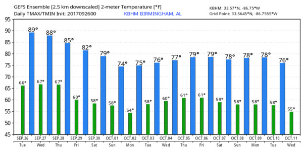
SUMMER-LIKE: We project a high close to 90 degrees today and tomorrow with a good supply of sunshine both days; that is about 8 degrees above average. But, we would need to get up into the mid 90s to threaten record highs. Today’s record high for Birmingham is 95 set in 1897, tomorrow’s record is 94 set in 1998.
COOLER DAYS: The upper ridge breaks down, we start the trend toward cooler temperatures later this week. The high Thursday will drop into the mid 80s, followed by low 80s Friday. The air stays dry and the sky will be mostly sunny both days.
THE ALABAMA WEEKEND: Very pleasant fall weather is the story; highs 77-80, lows 58-62 Saturday and Sunday. Lots of sun, low humidity. You certainly won’t be needing jackets and sweaters, but temperatures will be right at average values for the end of September and the first day of October.
FOOTBALL WEATHER: Perfect weather conditions for the high school games Friday night; clear with temperatures falling from 79 at kickoff, into the upper 60s by the fourth quarter.
Auburn hosts Mississippi State Saturday at Jordan-Hare Stadium (5:00p CT kickoff)… the sky will be clear with temperatures falling from 78 degrees at the start of the game, to near 68 by the final whistle.
Alabama will host the Ole Miss Rebels Saturday night in Tuscaloosa (8:00p CT kickoff)… with a clear sky, temperatures will fall from near 78 at kickoff, into the upper 60s by the fourth quarter.
NEXT WEEK: Dry, pleasant weather continues for the first half of the week, but global models show moisture returning by Thursday and Friday with a chance of showers. We also note both the GFS and the ECMWF hint at a surface low forming in the Gulf of Mexico in 8-10 days… we will have to watch for any potential “tropical mischief”. See the Weather Xtreme video for maps, graphics, and more details.
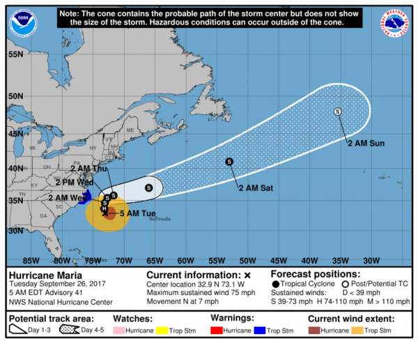
TROPICS: Hurricane Lee, in the Central Atlantic, will kick out into the open North Atlantic in coming days and is no threat to land. Closer to home, Maria is hanging on to hurricane status with winds of 75 mph; it will pass east of the North Carolina Outer Banks through tomorrow, and then kick out to sea later this week. A tropical storm warning remains in effect for the Outer Banks, where winds could exceed 39 mph. The rest of the Atlantic basin is quiet for now.
BEACH FORECAST: Click here to see the AlabamaWx Beach Forecast Center page. The Beach Forecast is partially underwritten by the support of Brett/Robinson Vacation Rentals in Gulf Shores and Orange Beach. Click here to see Brett/Robinson’s Hot Deals now!
WEATHER BRAINS: Don’t forget you can listen to our weekly 90 minute netcast anytime on the web, or on iTunes. This is the show all about weather featuring many familiar voices, including our meteorologists here at ABC 33/40.
CONNECT: You can find me on all of the major social networks…
Facebook
Twitter
Google Plus
Instagram
Pinterest
Snapchat: spannwx
I have a weather program this morning at Lynn Fanning Elementary School in Madison County, north of Huntsville… look for the next Weather Xtreme video here by 4:00 this afternoon. Enjoy the day!
Category: Alabama's Weather, ALL POSTS, Weather Xtreme Videos
About the Author (Author Profile)
James Spann is one of the most recognized and trusted television meteorologists in the industry. He holds the AMS CCM designation and television seals from the AMS and NWA. He is a past winner of the Broadcast Meteorologist of the Year from both professional organizations.Subscribe
If you enjoyed this article, subscribe to receive more just like it.


