

A Little Cooler Out There At Midday
CONDITIONS AT 1:00 PM IN CENTRAL ALABAMA

Skies across the area are mainly clear throughout the area with the exception of the southeastern parts of the area, where a few cumulus clouds are floating overhead.
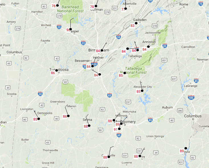
Temperatures at this point are in the upper 70s to the north, with upper 80s to the south. Birmingham is currently at 84 degrees.
FOR THE REST OF YOUR FRIDAY
We’ll have cooler temperatures in the northern half of Central Alabama, while the southern half remains very warm. Skies will be mostly sunny with afternoon highs topping out in the lower to mid-80s across the north, with upper 80s to lower 90s for the south. There is a very, very slight possibility for an isolated shower or two over portions of southeastern Central Alabama, almost too small to mention.
For this evening and through the overnight hours, any shower activity that may have formed during the afternoon hours will have diminished by 6-7 PM. Skies will be clear, with temperatures starting off in the mid-70s to the mid-80s throughout the area, and dropping to the mid-60s to the mid-70s by 10 o’clock. Overnight lows will dip down into the upper 50s to the upper 60s from north to south.
COOLER TEMPERATURES CONTINUE TO MOVE SLOWLY SOUTHWARD FOR THE WEEKEND
We’ll have mostly sunny to partly cloudy skies during the daytime hours with cool and fair nights throughout the weekend. No rain is expected throughout Central Alabama, but heat relief can be! Afternoon highs on Saturday will be in the lower 80s for the northern half of the area, with mid to upper 80s for the southern half. Sunday’s highs will be even cooler with mid-70s to the lower 80s expected throughout the area. Lows on both nights will be in the mid-50s to the mid-60s.
TEMPERATURES WARM SLIGHTLY BUT WE STAY DRY FOR THE WORK WEEK
We can expect nice and dry days throughout the first work week of October, with mostly clear to partly cloudy skies during the day and cool, fair nights. Highs will be in the upper 70s to the lower 80s to start, but will be in the lower to mid-80s to end off the week. Lows will mainly be in the 60s each night.
COLLEGE FOOTBALL
Mississippi State pays a visit to the Plains to take on Auburn. Kickoff will be around 5:00 PM. Skies will be mainly clear with temperatures starting off near 78 degrees at kickoff, and dropping to near 68 degrees by the end of the game.
Ole Miss pays a visit to Tuscaloosa to take on Alabama. Kickoff will be around 8:00 PM. Skies will be mainly clear with temperatures starting off near 74 degrees at kickoff, and dropping to the upper 60s by the end of the game.
AS OF NOW WE HAVE NO ACTIVE HURRICANES IN THE ATLANTIC BASIN
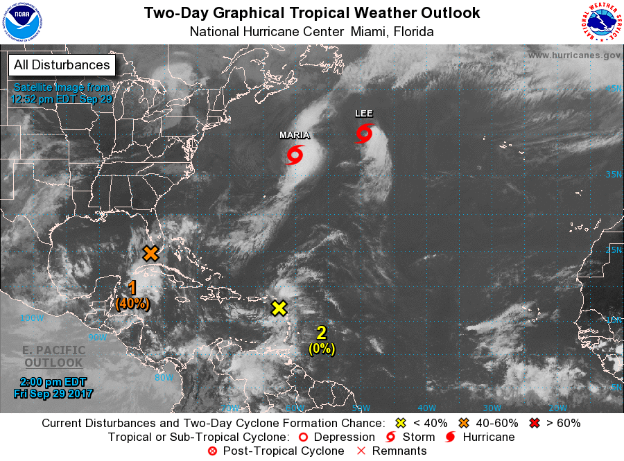
At this point, both Maria and Lee are heading away from the US Mainland and moving northeast, so we will no longer have to worry about these weakening tropical storms.
We do have two disturbances nearby… The first, Invest 99L, is located just south of Florida in the northwestern Caribbean Sea, and has a 40% chance of becoming a tropical depression or storm within the next 5 days. This has the potential to be a heavy rain producer over parts of the Florida Keys and the peninsula. Most of the guidance members have 99L moving northward over the peninsula before moving westward over the northern Gulf of Mexico. We’ll keep an eye on it.
The second disturbance is located near the Leeward Islands, but is unlikely to show any development over the next 5 days. This disturbance could bring locally heavy rains to parts of the Leeward Islands, Puerto Rico, and the US Virgin Islands.
OUR TROPICAL WEATHER CATEGORY HAS THE LATEST ON ALL ACTIVE STORMS
Stay up-to-date with the latest updates on all of the tropical systems out in the Atlantic Ocean, Caribbean Sea, or in the Gulf of Mexico with the latest posts in our Tropical Weather section. Click here to see the latest.
GOT BEACH PLANS?
Be sure to keep up to date with the detailed forecasts from Fort Morgan over to Panama City Beach with the AlabamaWx Weather Blog. Click here to see the AlabamaWx Beach Forecast Center page.
The Beach Forecast is partially underwritten by the support of Brett/Robinson Vacation Rentals in Gulf Shores and Orange Beach. Click here to see Brett/Robinson’s Hot Deals now!
ON THIS DAY IN WEATHER HISTORY
1986 – A week of violent weather began in Oklahoma which culminated in one of the worst flooding events in the history of the state. On the first day of the week early morning thunderstorms caused more than a million dollars damage in south Oklahoma City. Thunderstorms produced 4 to 7 inches of rain from Hobart to Ponca City, and another round of thunderstorms that evening produced 7 to 10 inches of rain in north central and northeastern sections of Oklahoma.
WEATHERBRAINS
Check out the show at www.WeatherBrains.com. You can also subscribe on iTunes. You can watch the show live at live.bigbrainsmedia.com on Monday nights starting at 8:30 PM CDT. You will be able to see the show on the James Spann 24×7 weather channel on cable or directly over the air on the dot 2 feed.
Category: Alabama's Weather, ALL POSTS
About the Author (Author Profile)
Scott Martin is an operational meteorologist, professional graphic artist, musician, husband, and father. Not only is Scott a member of the National Weather Association, but he is also the Central Alabama Chapter of the NWA president. Scott is also the co-founder of Racecast Weather, which provides forecasts for many racing series across the USA. He also supplies forecasts for the BassMaster Elite Series events including the BassMaster Classic.Subscribe
If you enjoyed this article, subscribe to receive more just like it.


