

Mainly Dry and Cool for a Couple of Days
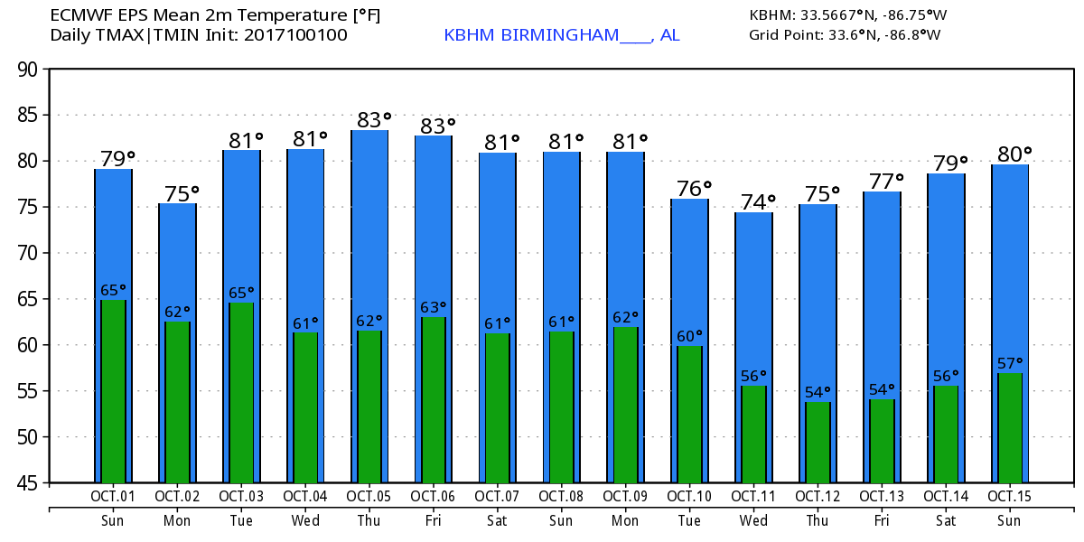
The morning satellite view of Alabama showed a few clouds across West Central and Southwest Alabama with the remainder of the state clear. The surface map this morning showed the surface high over Pennsylvania and New York to be just a tad stronger than the GFS forecast yesterday morning, so have set up a nice wedge situation. Temperatures reflect the wedge with mid 60s at Birmingham and Tuscaloosa with upper 50s along the Georgia line. We should see a fairly good supply of sunshine today, but the eastern sections of the state generally east of I-65 will see highs in the upper 70s while western sections are likely to reach the lower and middle 80s thanks to the wedge. Aloft we have we have a ridge extending from Alabama west to southwestward into northern Mexico.

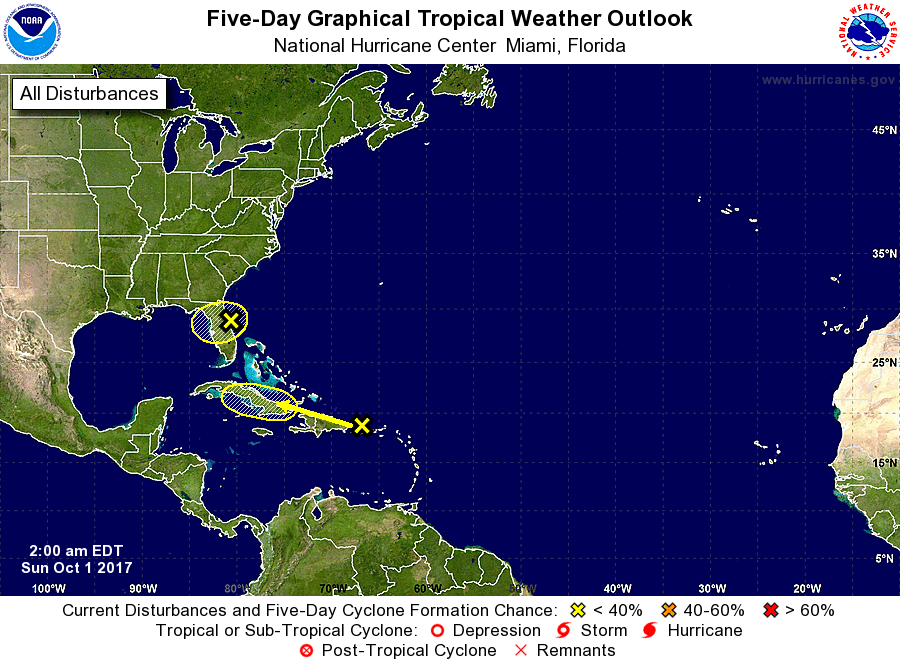
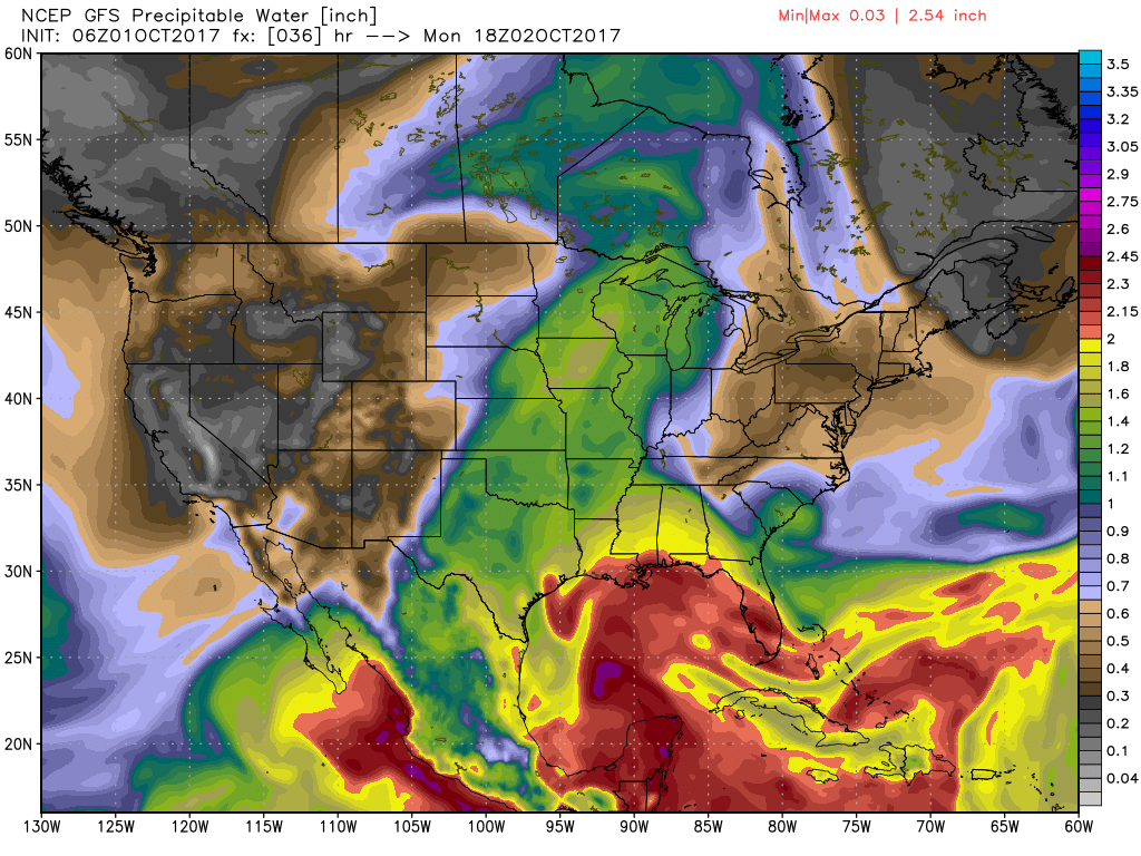
In the tropics, we’ve gone from four systems yesterday to just two today. We have one over North Florida and a second between the Dominican Republic and Puerto Rico. Neither system is expected to do much for the next five days, however, the one forecast to trek west-northwestward may bear watching since there is some potential for it to reach the Gulf of Mexico by the end of the week.
BEACH FORECAST: The beach weather looks a bit cloudy and wet for today and Monday becoming much better for beachgoers by Tuesday and the rest of the week. Highs are expected to be in the lower 80s through Tuesday warming up into the middle 80s for the latter portion of the week. Click here to see the AlabamaWx Beach Forecast Center page. The Beach Forecast is partially underwritten by the support of Brett/Robinson Vacation Rentals in Gulf Shores and Orange Beach. Click here to see Brett/Robinson’s Hot Deals now!
While it looks like much of the week ahead will be dry thanks mainly to a strong ridge aloft, we will have to deal with this disturbance over North Florida. It looks like it will be responsible for pushing moisture northward across southern Alabama on Monday bringing mostly cloudy skies to all of the state. Rain chances appear to be pretty low, 20 percent or less, so I think most of Central and North Alabama will remain dry. But with that surge of moisture, we’ll need to mention small chances here while across South Alabama and the Gulf Coast area showers and storms will be likely. The added clouds together with the presence of the wedge is likely to keep high temperatures Monday in the middle 70s.
Tuesday the disturbance along the Gulf Coast will move over to the Texas coast as the atmosphere dries out once again for Alabama and we return to sunshine. Highs will climb back into the lower half of the 80s. Wednesday and Thursday look great with a nice ridge aloft and a surface high over the southern Appalachians. Highs should be in the middle 80s.
When we get to the end of the week, model madness sets in! The disturbance near Puerto Rico appears to reach the Southeast Gulf of Mexico on Thursday according to the GFS while the Euro is considerably slower and further south. The GFS takes that system straight across the Gulf into South Texas near Brownsville by Saturday with what is likely to be a Category 1 or 2 hurricane. The Euro, on the other hand, strengthens the system along the western coast of Yucatan and then moves it northeastward toward South Florida and into the Tampa Bay area on Sunday as what appears to be a minimal hurricane. So, it looks like there is no consistency in the models, so just go ahead and make up whatever forecast you want for Friday and next weekend. For us, it does appear likely that we’ll see a weakening front come into the area by Saturday, so we’re likely to have some clouds and low end chances for rain, something in the 30 to 40 percent area. Afternoon highs will at least be in the middle 80s possibly pushing the upper 80s pretty hard depending on just how much cloudiness we see.
Looking out into voodoo country, a strong trough moves through the Great Lakes around the 10th of October suggesting a good chance for us to see a nice cold front push across the Southeast US. Ridging develops across the Southeast US once gain around the 13th of October promising some warm and dry Fall weather. But the storm track remains pretty busy with another strong trough moving through the Mississippi River Valley around the 15th suggesting another round of wet weather. So perhaps you need to check the status of your seat belts since we may be in for a wild ride during the month when things are supposed to be pretty tranquil.
WEATHER BRAINS: Don’t forget you can listen to our weekly 90 minute netcast anytime on the web, or on iTunes. This is the show all about weather featuring many familiar voices, including our meteorologists here at ABC 33/40.
Thanks for tuning into the Weather Xtreme Video. James Spann will be back with the next edition on Monday morning. You can catch the latest forecast this evening on ABC 3340 News at 5 and 10 pm where I will be filling in for Charles Daniel. Have a great day and Godspeed.
-Brian-
Category: Alabama's Weather, ALL POSTS
About the Author (Author Profile)
Brian Peters is one of the television meteorologists at ABC3340 in Birmingham and a retired NWS Warning Coordination Meteorologist. He handles the weekend Weather Xtreme Videos and forecast discussion and is the Webmaster for the popular WeatherBrains podcast.Subscribe
If you enjoyed this article, subscribe to receive more just like it.


