

Brighter, Warmer Today; Weekend Rain??
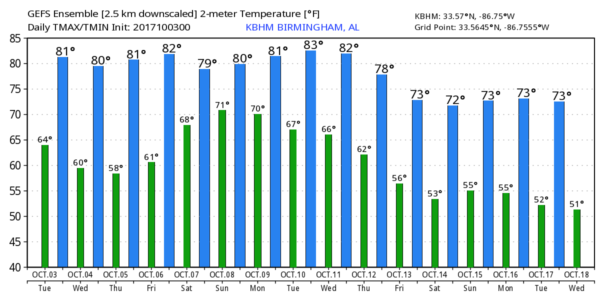
DRY THROUGH FRIDAY: An upper high will strengthen over the eastern third of the nation, and the associated subsidence should bring dry weather to our state through the rest of the week with mostly sunny, warm days and fair pleasant nights. Highs will be in the low to mid 80s, with lows in the 58-62 degree range most mornings.
The western U.S. is under a deep, cold upper trough, where the weather is more like winter. The Rockies have experienced a good bit of snow over the past 24 hours, and winter storm warnings remain in effect for parts of Montana this morning. Great Falls reports snow at 4:00a MT with 29 degrees and a brisk northwest wind gusting to 33 mph.
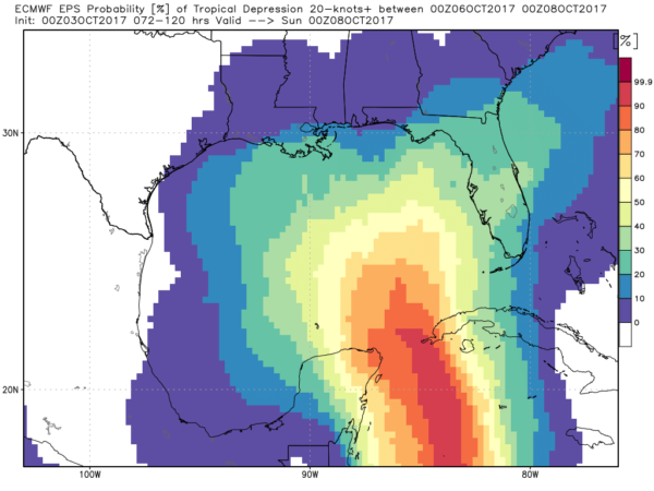
THE ALABAMA WEEKEND: Global models strongly suggest some kind of tropical low will form over the Gulf of Mexico late this weekend, potentially moving north/northeast and impacting Alabama’s weather. But, confidence in any specific solution is low at this point. The American model, the GFS, brings a deep swatch of moisture into the state Saturday, with rain likely at times both Saturday and Sunday.
The more reliable European model (ECMWF) still shows a dry day Saturday, followed by a chance of rain Sunday as a tropical low approaches the coast. If this solution is correct, rain would also be possible Sunday night and Monday, with the heaviest rain for the east and southeast counties of the state.
Bottom line for now I will mention just an outside risk of a shower Saturday, followed by a better chance of rain at times Sunday into Monday with highs in the low 80s. We will have much better clarity in coming days.
NEXT WEEK: After the chance of rain early in the week, cooler air should follow with highs dropping into the 70s and lows in the 50s. See the Weather Xtreme video for maps, graphics, and more details.
TROPICS: A weak surface trough near the Bahamas is not expected to develop; all eyes will be on the Gulf of Mexico for the chance of development as discussed above in coming days. While potential for a tropical low is fairly high, it remains to be seen if it becomes a depression or storm. One way or another, for now, it seems like the main impact will be rain for parts of the Gulf Coast region/Southeast U.S. this weekend and early next week.
BEACH FORECAST: Click here to see the AlabamaWx Beach Forecast Center page. The Beach Forecast is partially underwritten by the support of Brett/Robinson Vacation Rentals in Gulf Shores and Orange Beach. Click here to see Brett/Robinson’s Hot Deals now!
WEATHER BRAINS: Don’t forget you can listen to our weekly 90 minute netcast anytime on the web, or on iTunes. This is the show all about weather featuring many familiar voices, including our meteorologists here at ABC 33/40.
CONNECT: You can find me on all of the major social networks…
Facebook
Twitter
Google Plus
Instagram
Pinterest
Snapchat: spannwx
I have a weather program this morning at Blountsville Elementary School… be looking for the next Weather Xtreme video here by 4:00 this afternoon. Enjoy the day!
Category: Alabama's Weather, ALL POSTS, Weather Xtreme Videos
About the Author (Author Profile)
James Spann is one of the most recognized and trusted television meteorologists in the industry. He holds the AMS CCM designation and television seals from the AMS and NWA. He is a past winner of the Broadcast Meteorologist of the Year from both professional organizations.Subscribe
If you enjoyed this article, subscribe to receive more just like it.


