

Watching Tropical Developments Closely
DRY THROUGH TOMORROW: The easiest part of this forecast (like most) involves the next 48 hours. Look for dry weather across Alabama through tomorrow; a good supply of sunshine both days with highs in the mid 80s. We do note we have a cool start this morning across Northeast Alabama, where our Skywatcher Vic Bell reports a refreshing 49 degrees just before daybreak.
TROPICAL STORM NATE: Our weekend weather will be determined by the behavior of newly upgraded Tropical Storm Nate, now skirting the coast of Central America in the far western Caribbean. Here are the key points this morning…
*NHC has adjusted the track to the west overnight, now suggesting landfall will come across Southeast Louisiana, and then South Mississippi Sunday morning. But, don’t focus on the exact forecast track, especially at the longer ranges, since the average NHC track errors are about 175 and 225 statute miles at days 4 and 5, respectively. More changes are very possible.
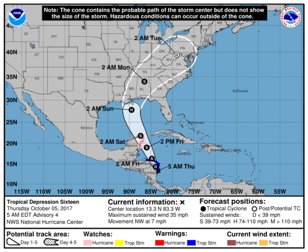
*The European global model shifted to the west on the 00Z run, in better agreement with the GFS and other tropical models. But, there is considerable disagreement concerning the timing of landfall; the Euro is much slower, showing the system moving into the Central Gulf Coast Sunday evening. On the other hand, the North American Mesoscale (NAM) model shows landfall late Saturday afternoon. The bottom line is that uncertainty remains in the forecast.
*NHC suggests that “Nate” will be a category one hurricane at the time of landfall, but the system will encounter cooler water near the coast, some westerly shear, and also some dry air. The last two runs of the GFS shows only a weak tropical depression or storm moving up into the Gulf Coast, and the NAM is in fairly good agreement. So, there is a chance this doesn’t reach hurricane strength. But, there is only marginal skill in forecasting the intensity of a tropical cyclone four days in advance.
*One way or another, we believe the main threat will be heavy rain along and east of the circulation center. The new forecast track from NHC puts much of Alabama on the wet side. Rain amounts of 2-4 inches will be possible across the state, with most of the rain coming Saturday night and Sunday.
*We note SPC has a “marginal risk” of severe weather defined for the Central Gulf Coast Saturday; a few isolated tornadoes are possible there.
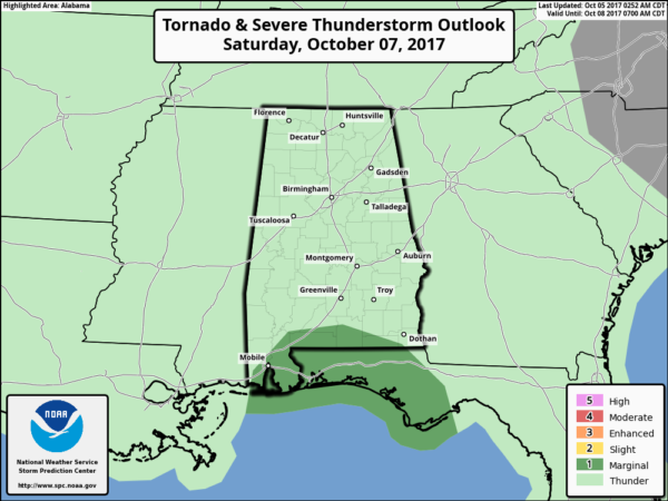
*It is too early to know if there will be a tornado threat inland across Alabama Saturday night and Sunday. It depends on the strength and structure of the tropical system.
*If you have a beach trip planned this weekend, I would still hold off on changing plans until later today. But, it looks fairly certain that the weekend will be wet and windy for places like Gulf Shores, Pensacola Beach, Destin, and Panama City Beach. Conditions there improve Monday.
THE ALABAMA WEEKEND: The best chance of rain Saturday will come across the southern quarter of Alabama, although scattered showers are possible statewide by Saturday afternoon. The more widespread rain should come Saturday night and Sunday.
FOOTBALL WEATHER: For the high school games tomorrow night, the sky should be clear with temperatures falling from around 80 degrees at kickoff, through the 70s during the game.
Auburn hosts Ole Miss Saturday at Jordan-Hare Stadium (11:00a CT kickoff)… the sky will be partly sunny with temperatures rising from near 78 degrees at kickoff into the low 80s by the final whistle. A few widely scattered showers are possible.
Alabama is on the road; they will take on the Texas A&M Aggies Saturday in College Station, Texas Saturday evening (6:15p CT kickoff). The sky will be clear with temperatures falling from near 88 degrees at kickoff, to near 80 by the end of the game.
UAB’s homecoming is Saturday; the Blazers take on Louisiana Tech at Legion Field (3:00p CT kickoff)… for now we are forecasting a partly sunny sky with only widely scattered showers. About 83 degrees at kickoff, falling to near 80 by the fourth quarter.
Please keep in mind the forecast for the Auburn and UAB is subject to change due to the tropical system in the Gulf of Mexico.
NEXT WEEK: Moisture will linger across the state for the first half of the week with some risk of showers each day Monday through Wednesday. Then, cooler, drier air should filter into the state Thursday and Friday.
BEACH FORECAST: Click here to see the AlabamaWx Beach Forecast Center page. The Beach Forecast is partially underwritten by the support of Brett/Robinson Vacation Rentals in Gulf Shores and Orange Beach. Click here to see Brett/Robinson’s Hot Deals now!
WEATHER BRAINS: Don’t forget you can listen to our weekly 90 minute netcast anytime on the web, or on iTunes. This is the show all about weather featuring many familiar voices, including our meteorologists here at ABC 33/40.
CONNECT: You can find me on all of the major social networks…
Facebook
Twitter
Google Plus
Instagram
Pinterest
Snapchat: spannwx
I have a weather program this morning at East Elementary in Cullman… look for the next Weather Xtreme video here by 4:00 this afternoon. Enjoy the day!
Category: Alabama's Weather, ALL POSTS, Weather Xtreme Videos
About the Author (Author Profile)
James Spann is one of the most recognized and trusted television meteorologists in the industry. He holds the AMS CCM designation and television seals from the AMS and NWA. He is a past winner of the Broadcast Meteorologist of the Year from both professional organizations.Subscribe
If you enjoyed this article, subscribe to receive more just like it.


