

Near Midday Thoughts on Tropical Storm Nate
The latest official track from the National Hurricane Center currently has Nate heading on a mostly north-northwesterly track that will take it across the tip of the Yucatan Peninsula on Friday night before emerging into the Gulf of Mexico and strengthening to a hurricane by Saturday morning. As Nate makes the approach to the Gulf Coast, it is forecast to strengthen up to maximum sustained winds up to 85 MPH, before slight weakening at landfall on Sunday morning. Current projected landfall of the center is around the New Orleans area then moving onshore again near Gulfport and Biloxi.
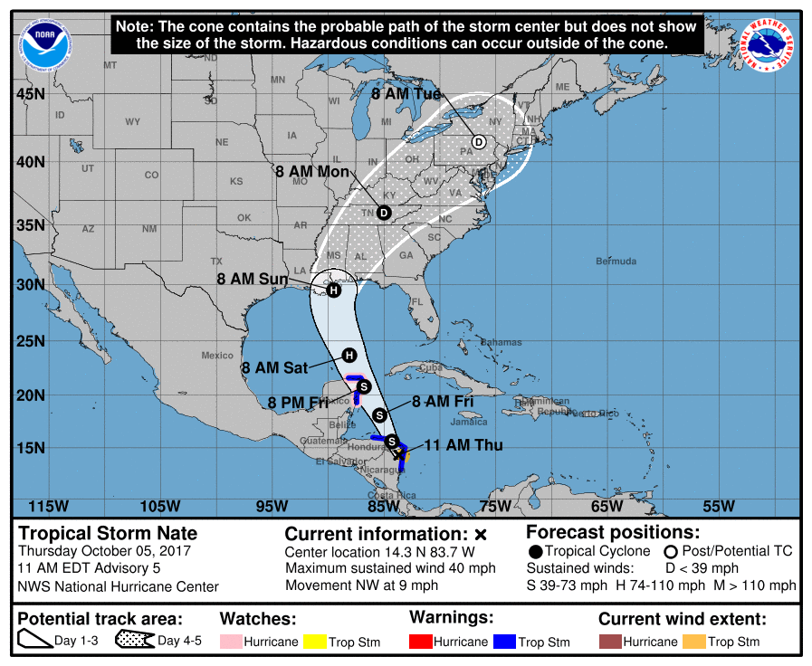
On this current forecast track, we could see sustained tropical storm force winds up to 50 MPH with gusts up to 60 MPH on the Alabama Gulf Coast, and lower as you move east towards Destin and Panama City Beach. Conditions will really start to deteriorate on Saturday afternoon as the first feeder bands start moving in along with increasing winds. At this point, tropical-type tornadoes will start to be a threat as all of the Alabama Gulf Coast will be on the eastern side of the center.
The center of Nate will move northeasterly through Alabama during the day on Sunday while weakening, and is forecast to pass over the Birmingham Metropolitan Area Sunday evening before arriving near Oak Hill, Tennessee (west of Knoxville) on Monday morning. All of Central Alabama will have rain and wind to deal with, but the worst weather will come mainly for the eastern half of Central Alabama throughout the day on Sunday, with very gusty winds up to tropical storm force (40-50 MPH), very heavy rain, and possible spin-up tornadoes. The western half of the state will see heavy rain and gusty winds as well, but will be slightly less of a factor since the center will be east. Weather will gradually start to improve during the early morning hours on Monday and most of the activity will be out of the state by Monday Afternoon.
FORECAST MODELS
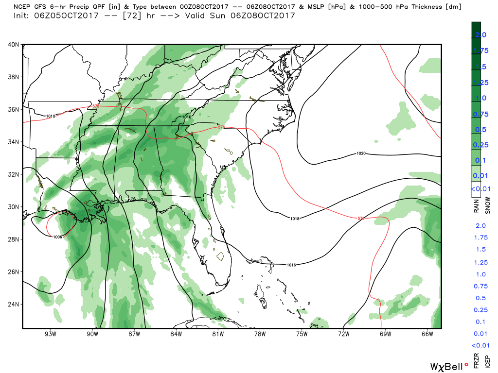
The forecast models are closer than in previous runs concerning the future track on Tropical Storm Nate. The GFS really keeps Nate as a weak tropical storm moving onshore near Franklin, Louisiana, and moving northeasterly through central and eastern Mississippi. With this solution, much of the heavier rainfall will be over Central Alabama and there could be a lower risk for tropical spin-up tornadoes. Winds could be gusty at times but much lower than what they would be for the NHC forecast track. When the new GFS data is out, it will have the information from the latest high-altitude Hurricane Hunter mission.
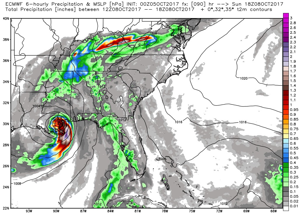
The European is really close to the GFS solution as a strong tropical storm, with the center making its way through eastern Mississippi and into northwestern Alabama. Winds will be a little stronger than the GFS solution with heavy rain and a few tornadoes possible.
This can all change with the next run of all the models, including the forecast track from the National Hurricane Center. Please remember that the effects of Nate will be felt outside of the cone that is shown on the graphic. We’ll have updates throughout the day on the future track of Nate.
About the Author (Author Profile)
Scott Martin is an operational meteorologist, professional graphic artist, musician, husband, and father. Not only is Scott a member of the National Weather Association, but he is also the Central Alabama Chapter of the NWA president. Scott is also the co-founder of Racecast Weather, which provides forecasts for many racing series across the USA. He also supplies forecasts for the BassMaster Elite Series events including the BassMaster Classic.Subscribe
If you enjoyed this article, subscribe to receive more just like it.


