

Thursday Night Thoughts On Tropical Storm Nate
WHAT TO EXPECT WITH NATE
Nate is forecast to reach the northern Gulf Coast this weekend as a category 1 hurricane, and the threat of direct impacts from wind, storm surge, and heavy rainfall is increasing from Louisiana through the Florida Panhandle, including all of the Alabama Gulf Coast. A Hurricane Watch and a Storm Surge Watch will likely be issued either later tonight or by Friday morning.
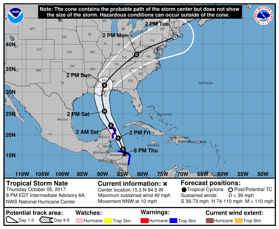
Nate is expected to gradually strengthen as it gets closer to the coastline this weekend. The impacts for Central Alabama will be determined by the exact track and the strength Nate can achieve.
What we can expect with Nate with the current forecast track from the National Hurricane Center over Central Alabama at this point will be heavy rainfall ranging from 1.50 inches to 4.00 inches throughout the area, winds in excess of 20-40 MPH throughout much of the area with 30-50 MPH closest to the center, and a few tropical spin-up tornadoes mainly northeast and east of the center as Nate moves through. Nate will be weakening as he transverses the state from southwest to northeast, so the wind threat will steadily lessen the farther northeast the system goes.
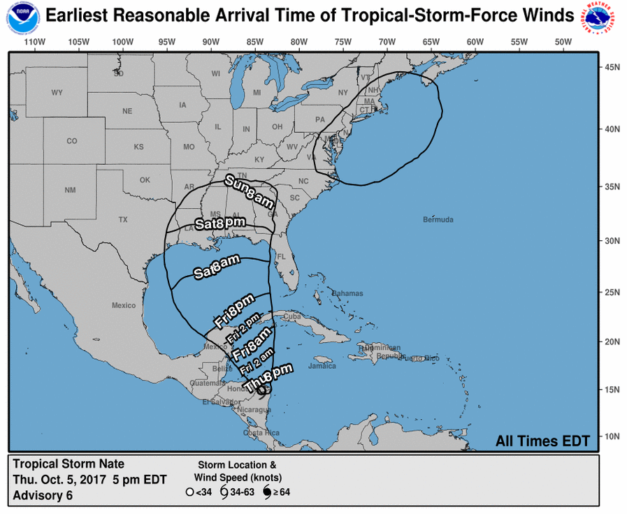
The main timing for Nate to affect the area will be from Saturday morning through Tuesday morning, with the strongest storms occurring during the Sunday morning to Monday morning time frame. We will have a better handle of the forecast for Central Alabama as we get a clear and near-exact track for Nate to take.
BEACH WEATHER
Conditions along the Gulf Coast will start to deteriorate starting on Saturday morning as the first feeder bands from Nate will start moving onshore and will continue to worsen until the center passes by and moves north of the beaches on Sunday morning. Rain is likely to continue until very late on Sunday night or into the pre-dawn hours on Monday. At this point, with the Alabama Gulf Coast being on the east side of the center, stronger winds of tropical storm force can be expected with the possibility of tornadic waterspouts and spin-up tornadoes. Life threatening rip currents and dangerous surf can be expected throughout the weekend, and some flooding from storm surge and heavy rainfall is possible.
ALABAMA UNDER A STATE OF EMERGENCY STARTING FRIDAY MORNING
Governor Kay Ivey has issued a State of Emergency for the entire state, allowing resources and personnel to be freed up and available to respond to any storm related activity if needed. The State of Emergency goes into effect at 7:00 AM on Friday morning and will remain until the threat diminishes.
VOLUNTARY EVACUATIONS ISSUED FOR BALDWIN COUNTY
The Baldwin County Commission, along with the cities of Gulf Shores, Orange Beach, and Spanish Fort have issued a voluntary evacuation for all locations south of State Highway 182 (Perdido Beach Blvd., East & West Beach Blvd.), the Fort Morgan Peninsula, and all low-lying and flood prone areas in southern Baldwin County, starting Friday morning. Along with the voluntary evacuations, double-red flags will be raised and beaches will be closed for swimming. All persons are directed to stay out of the water.
About the Author (Author Profile)
Scott Martin is an operational meteorologist, professional graphic artist, musician, husband, and father. Not only is Scott a member of the National Weather Association, but he is also the Central Alabama Chapter of the NWA president. Scott is also the co-founder of Racecast Weather, which provides forecasts for many racing series across the USA. He also supplies forecasts for the BassMaster Elite Series events including the BassMaster Classic.Subscribe
If you enjoyed this article, subscribe to receive more just like it.


