

An Evening Look at Nate’s Intensity, Track
Tropical Storm Nate continues to slowly become better organized and intensify tonight as it is passing directly through the Yucatan Channel between the Yucatan Peninsula and western Cuba. Storms around the center of the storm continue to slowly grow in intensity.
Maximum flight level winds are still near 80 mph, putting the intensity of the storm somewhere around 65-70 mph.
The storm will not suffer any land interaction as it makes the transit tonight which means it will not weaken any.
Shear over the southern Gulf of Mexico is running about 6-12 knots and will only increase slightly Saturday evening. This means that Nate should continue to slowly intensify and should become a hurricane by morning. The SHIPS intensity model indicates that there is a 45% chance that it will intensify by 25 knots of 30 mph over the next 24 hours. By tomorrow evening, Nate could be at 80 knots, or 90-95 mph. This would make it a strong category one hurricane.
The storm is over water that is warmer than 29.5 degrees C. That should be the case through early afternoon tomorrow. Nate has been over high oceanic heat content, but that will decrease over the Gulf of Mexico.
Weak outflow appears to be evident. There is slight upper-level divergence, which aids in that outflow. Low-level convergence ahead of the storm is weak. These factors help us believe that it won’t intensify much beyond that.
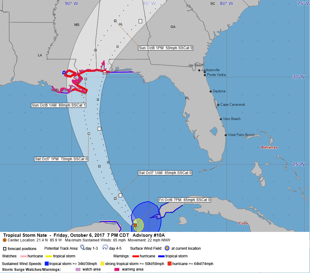
The official NHC forecast has it at 70 mph tomorrow afternoon and intensifies it to 80 mph before it makes landfall. But residents along the coastal sections of the Gulf Coast should prepare for a slightly stronger hurricane than forecast.
The most likely case is that the center will pass near the mouth of the Mississippi River just before midnight tomorrow evening and make landfall on the Mississippi coast near Biloxi around 2 a.m. Sunday morning. It will be turning northeast into Southwest Alabama at that time. The track will cause hurricane force winds (74 mph or greater) and strong tropical storm force winds (58 mph or greater) to be felt along the Mississippi Coast. New Orleans would be spared in that scenario from strong TS force or hurricane winds.
But a worst case scenario for them would produce those hurricane force winds to be felt in New Orleans and over Lake Ponchartrain early Sunday morning. In this scenario, the Mississippi coast would experience tropical storm force winds and the Alabama coast would not.
The worst-case scenario for the Alabama coast is possible (10% chance), putting the center near Mobile Bay around 1 a.m. Sunday morning. This would, of course, bring hurricane force winds to the Alabama coast late tomorrow night and Sunday morning. Tropical storm force winds would be felt as far east at the communities along 30A in Northwest Florida, including Pensacola, Navarre, Fort Walton, Destin and Seagrove/Seaside.
Residents and visitors along the Gulf Coast in the hurricane and tropical storm warning areas need to assess their risk in the light of these forecast possibilities and prepare for the worst case scenario appropriate for their location. In fact, preparations should be made for one category stronger than forecast, meaning preparations should be made for a category two hurricane.
I will have a thorough look at impacts along the Gulf Coast shortly.
About the Author (Author Profile)
Bill Murray is the President of The Weather Factory. He is the site's official weather historian and a weekend forecaster. He also anchors the site's severe weather coverage. Bill Murray is the proud holder of National Weather Association Digital Seal #0001 @wxhistorianSubscribe
If you enjoyed this article, subscribe to receive more just like it.


