

Very Nice Out There At Midday
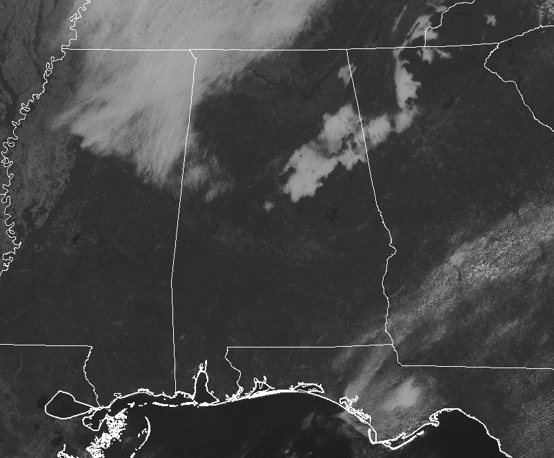
Radars for both Birmingham and Columbus are both down for maintenance at 11:20 AM on this fine Thursday, and looking at the other surrounding radars, it appears to be dry at this point in Central Alabama. The good news is that the radar outages are expected to be over by noon. The latest visible satellite shows mainly clear skies for most in Central Alabama, with the exception of some cloud cover over parts of the northeast and extreme northwestern parts of the area. Temperatures at this point are currently running in the mid-60s to the lower 70s for most in the northern half of the area, with a steep jump into the mid-70s to the mid-80 in the south.
What To Expect For The Rest Of Your Thursday
While the cold front has moved through Central Alabama, the cooler temperatures still hasn’t reached everyone in the area. We’ll have a good supply of sunshine throughout the remainder of the daylight hours with only a few clouds floating overhead. Much of the area will see highs in the upper 70s to the lower 80s, while the southeastern corner of the area will see highs in the mid-80s to at or near 90 degrees.
Dewpoint levels will continue to fall across the area for this evening and into the overnight hours, and skies will be mostly clear. Overnight lows will be in the mid-50s to the upper 60s throughout Central Alabama from north to south.
Dry For Most On Friday, Some Isolated Showers Possible
The cold front continues to linger south and east of Central Alabama and there will be a shift in the flow out of the east, causing an increase in moisture over the eastern parts of the area. Much of the area will have mostly sunny skies and dry conditions, but isolated showers will be possible along and east of a line from Montgomery to Alexander City to Anniston. We’ll have warmer afternoon highs in the mid to upper 80s throughout the area.
Any rain chances will dissipate as we lose the sunlight and daytime heating. For the high school football games, weather will be rather nice underneath mostly clear skies. Temperatures will be in the mid-70s to the lower 80s throughout the area just before kickoff, and falling into the mid-60s to the lower 70s by the final whistle. Overnight lows will range throughout the 60s.
The Central Alabama Weekend
We will continue to stay warm with moisture advecting into the area as we’ll have a another cold front approaching and will make its way into the area late Sunday evening. The upper ridge will continue its hold on our pattern for Saturday with mostly clear to partly cloudy skies and only a slight risk of an isolated shower throughout the area. Ridging breaks down as the cold front gets closer and starts to invade the area on Sunday, but only isolated showers are possible again as we will be lacking any forcing to cause development. Highs will be in the lower to mid-80s for most.
Race Weekend At Talladega
The weather will be dry at the Superspeedway through Saturday with warm afternoons and pleasant nights. Highs each day will be in the 80s. Humidity levels will be fairly low today and tomorrow, but they will be rising over the weekend. For Sunday, the sky will be partly sunny, and we will mention a small risk of a brief shower. The high will be in the mid-80s.
College Football Weather
Alabama will host the Arkansas Razorbacks Saturday evening (6:15p CT kickoff) at Bryant-Denny Stadium in Tuscaloosa for homecoming. Skies will be mostly fair. About 82 degrees at kickoff, falling to near 75 degrees by the final whistle.
Auburn travels to Baton Rouge to take on LSU Saturday afternoon (2:30p CT kickoff). Sunny skies, with the temperature close to 88 degrees at kickoff, falling back into the low 80s by the fourth quarter.
UAB will host Middle Tennessee at Legion Field in Birmingham Saturday evening (5:30p CT kickoff). Clear skies with temperatures falling from near 83 at kickoff, into the 70s by the second half.
The Tropics Are Quiet Close To Home
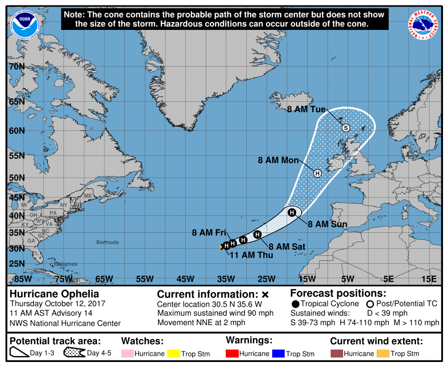
Ophelia continues to meander around southwest of the Azores, but is expected to start moving off to the northeast later today, followed by a faster east-northeastern motion on Friday. For the rest of the Atlantic Basin, tropical cyclone formation is not expected during the next five days.
Stay up-to-date with the latest updates on all of the tropical systems out in the Atlantic Ocean, Caribbean Sea, or in the Gulf of Mexico with the latest posts in our Tropical Weather category. Click here to see the latest.
Gulf Coast Weather
Beautiful weather down along the beaches through Saturday, but a few scattered storms are possible on Sunday. Highs will be in the 80s, with lows in the 70s.
Be sure to keep up to date with the detailed forecasts from Fort Morgan over to Panama City Beach with the AlabamaWx Weather Blog. Click here to see the AlabamaWx Beach Forecast Center page.
The Beach Forecast is partially underwritten by the support of Brett/Robinson Vacation Rentals in Gulf Shores and Orange Beach. Click here to see Brett/Robinson’s Off Season Deals now!
On This Day In Weather History
1962 – The “Columbus Day Big Blow” occurred in the Pacific Northwest. It was probably the most damaging windstorm of record west of the Cascade Mountains. Winds reached hurricane force, with gusts above 100 mph. More than 3.5 billion board feet of timber were blown down, and communications were severely disrupted due to downed power lines. The storm claimed 48 lives, and caused 210 million dollars damage.
WeatherBrains
Check out the show at www.WeatherBrains.com. You can also subscribe on iTunes. You can watch the show live at live.bigbrainsmedia.com on Monday nights starting at 8:30 PM CDT. You will be able to see the show on the James Spann 24×7 weather channel on cable or directly over the air on the dot 2 feed.
Category: Alabama's Weather, ALL POSTS
About the Author (Author Profile)
Scott Martin is an operational meteorologist, professional graphic artist, musician, husband, and father. Not only is Scott a member of the National Weather Association, but he is also the Central Alabama Chapter of the NWA president. Scott is also the co-founder of Racecast Weather, which provides forecasts for many racing series across the USA. He also supplies forecasts for the BassMaster Elite Series events including the BassMaster Classic.Subscribe
If you enjoyed this article, subscribe to receive more just like it.


