

Rain Returns Sunday Night/Monday
ANOTHER CHILLY MORNING: Coldest spot we can find early this morning is Black Creek, just northeast of Gadsden, with 36 degrees. Most communities are in the 40s, and some are in the low 50s. The sky is clear, and the day ahead will feature a good supply of sunshine with a high in the 77 to 80 degree range.
THE ALABAMA WEEKEND: We stay dry tomorrow, but humidity levels will creep up a bit. The sky will be partly to mostly sunny with a high at or just over 80 degrees. Then, on Sunday, we will have a mix of sun and clouds with a high between 79 and 82. We will mention a chance of widely scattered afternoon showers, but most of the rain holds off until Sunday night as a cold front approaches.
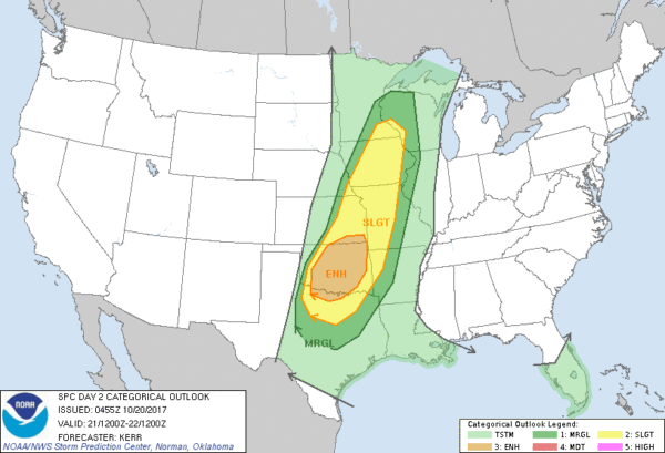
We note SPC has defined a severe weather threat tomorrow and tomorrow night from Texas to Minnesota, but no organized severe weather is expected Sunday or Monday for now due to low instability values and relatively weak wind fields.
FOOTBALL WEATHER: A great night for high school games tonight; the sky will be clear with temperatures falling from near 72 degrees at kickoff, into the low 60s by the final whistle.
Tomorrow, Alabama hosts the Tennessee Volunteers (2:30p CT kickoff) at Bryant-Denny Stadium… the game will be played under a partly to mostly sunny sky. About 81 degrees at kickoff; mid 70s by the fourth quarter as the sun begins to fade in the west.
Auburn travels to Fayetteville, Arkansas to take on the Razorbacks (6:30p CT kickoff)… while we can’t rule out a shower or storm during the game, confidence is growing that the main band of showers and storms won’t arrive there until after the game is over tomorrow night. And, we should mention that severe storms are possible in Fayetteville late Saturday night into the pre-dawn hours Sunday. Temperatures will fall from near 72 degrees at kickoff, into the 60s by the fourth quarter.
UAB will also be on the road; they take on the Charlotte 49ers tomorrow (5:30p CT kickoff)… expect a clear sky with temperatures falling from near 71 degrees at kickoff into the low 60s by the final whistle.
MONDAY SOAKER: A wave of low pressure is forecast to form along the cold front moving through Alabama Monday, setting up a big rain event statewide. Rain amounts are expected to average two inches, with isolated 3 inch totals possible. Thunderstorms are possible, but no severe weather is expected.
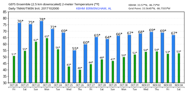
REST OF THE WEEK: Rain ends early Tuesday, followed by gradual afternoon clearing as cool, dry air moves in. The coolest air so far this season is due in here by Wednesday and Thursday with potential for highs in the 50s and lows in the 30s in spots.
TROPICS: The Atlantic basin remains very quiet, and tropical storm formation is not expected though next week.
BEACH FORECAST: Click here to see the AlabamaWx Beach Forecast Center page. The Beach Forecast is partially underwritten by the support of Brett/Robinson Vacation Rentals in Gulf Shores and Orange Beach. Click here to see Brett/Robinson’s Hot Deals now!
WEATHER BRAINS: Don’t forget you can listen to our weekly 90 minute netcast anytime on the web, or on iTunes. This is the show all about weather featuring many familiar voices, including our meteorologists here at ABC 33/40.
CONNECT: You can find me on all of the major social networks…
Facebook
Twitter
Google Plus
Instagram
Pinterest
Snapchat: spannwx
I have a weather program this morning at Bluff Park Elementary in Hoover… look for the next Weather Xtreme video here by 4:00 this afternoon. Enjoy the day!
Category: Alabama's Weather, ALL POSTS, Weather Xtreme Videos
About the Author (Author Profile)
James Spann is one of the most recognized and trusted television meteorologists in the industry. He holds the AMS CCM designation and television seals from the AMS and NWA. He is a past winner of the Broadcast Meteorologist of the Year from both professional organizations.Subscribe
If you enjoyed this article, subscribe to receive more just like it.


