

Wet into Monday then Colder
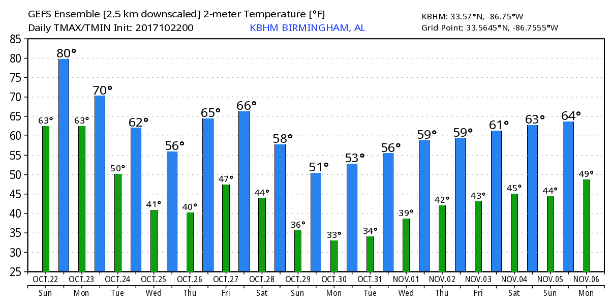
The high in Birmingham yesterday afternoon was 80 degrees, and that may be the last time we see an 80-degree reading for quite some time. The stage is set for a very impressive upper trough to swing through the eastern US over the next couple of days driving temperatures downward.
The satellite image to start the day showed clouds over much of Alabama though there were breaks in some spots especially along the eastern side of the state and into Southeast Alabama. The clouds were coming from thunderstorms occurring over southern Mississippi and southeastern Louisiana well ahead of the cold front. Clouds will continue to increase over Alabama today as the cold front, currently located in western Arkansas, continues to make steady progress eastward. Much of Alabama will remain dry through the morning hours with the exception of the western counties. Highs today will be somewhat limited by cloud cover but also buoyed by the increasing southerly flow, so we should see highs in the upper 70s.

During the afternoon rain and storms should advance across the state with much of the state covered by rain this evening. The threat of severe weather is low, but not zero. CAPE values are forecast to surge northward ahead of the front with the highest values centered over Southwest Alabama, Southeast Mississippi, and Southeast Louisiana where SPC has outlined a marginal risk for severe storms. Weak lapse rates aloft should limit the amount of severe weather, and while damaging wind will be the biggest concern, some large hail and a tornado or two cannot be completely ruled out.
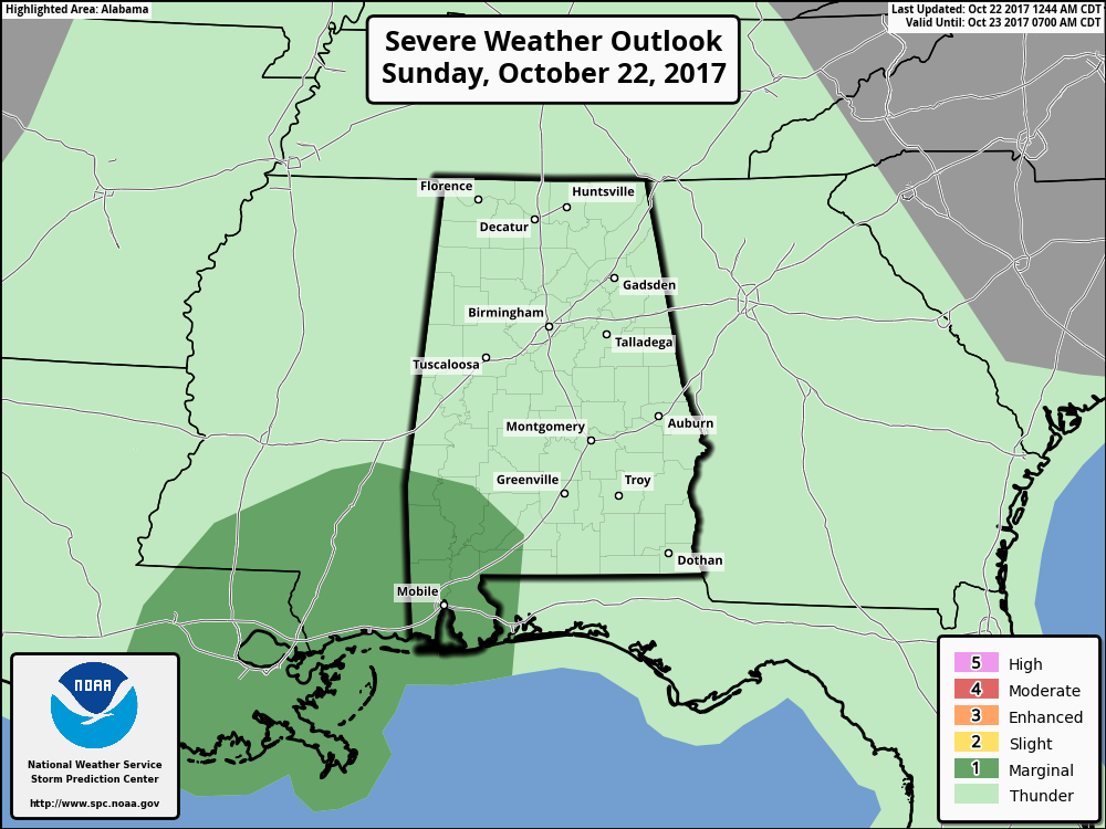
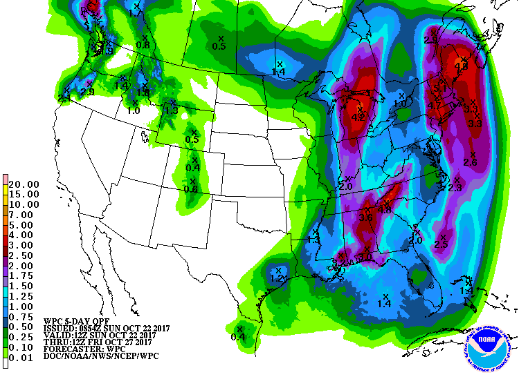
Rainfall amounts still look substantial for much of Alabama. WPC has nearly all of the state in the standard slight risk for excessive rainfall for today, Day 1, which goes until early Monday morning. Total rainfall across the state is likely to be in the 2 to 3 inch range with the potential for some of the eastern half of the state seeing rainfall amounts nearing 4 inches. Widespread flash flooding is not anticipated at this time, but some locations could see some isolated flash flood concerns in locations where flash flooding is typically a problem.
Tropics: There are no areas of disturbed weather today, and tropical storm formation is not expected across the Atlantic basin into next week.
Beach Forecast: Click here to see the AlabamaWx Beach Forecast Center page. The Beach Forecast is partially underwritten by the support of Brett/Robinson Vacation Rentals in Gulf Shores and Orange Beach. Click here to see Brett/Robinson’s Hot Deals now!
The strong upper trough driving the cold front through the eastern US will really dig into the Southeast US on Tuesday bringing what could be the coldest air of the season into Central Alabama. The coldest day so far this Fall was 46 degrees on October 18th, but the GFS MOS guidance is printing out a low of 41 degrees for Wednesday morning. This means that some of those typically colder locations are likely to see morning lows well into the 30s with the potential for some light frost. Highs Tuesday and Wednesday should be in the 60s.
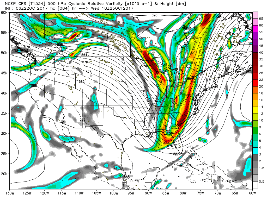
The trough moves on briskly moving out into the Atlantic with weak ridging coming into place by Thursday, so the weather will stay dry and we should see highs warm nicely into the 70s for the end of the week. The forecast for the weekend depends on whether you follow the GFS or the ECMWF. The GFS is rather fast with the next system digging another upper level trough into the Lower Mississippi River Valley on Saturday. This would bring the cold front and rain through Alabama on Saturday, but the ECMWF is much slower with this system holding the trough’s passage across the Mississippi River until early Tuesday. So there is a big difference in model solutions for the forecast for next weekend. I think the ECMWF seems way too slow, while the GFS may be a little too fast. The most probably solution is likely to be a dry Saturday with rain coming into the Southeast US on Sunday, so we’ll probably see the ECMWF speed up a little while the GFS slows down the forward motion of the upper trough.
Looking into voodoo country, the GFS maintains the troughiness and chilly pattern over the eastern US as we enter November with another strong trough moving through the pattern on the 2nd of November. We should warm some through the 6th with weak riding in place over the eastern US with another digging trough on the radar headed our way around the 6th. As we’re getting into the latter part of October, it is not surprising to see the idea of a fairly fast upper flow pattern take shape.
WEATHER BRAINS: Don’t forget you can listen to our weekly 90 minute netcast anytime on the web, or on iTunes. This is the show all about weather featuring many familiar voices, including our meteorologists here at ABC 33/40.
James Spann will have the next Weather Xtreme Video here to start your Monday. Be sure to have some rain gear handy if you plan to venture out later today, tonight, or first thing on Monday morning. Godspeed.
-Brian-
Category: Alabama's Weather, ALL POSTS
About the Author (Author Profile)
Brian Peters is one of the television meteorologists at ABC3340 in Birmingham and a retired NWS Warning Coordination Meteorologist. He handles the weekend Weather Xtreme Videos and forecast discussion and is the Webmaster for the popular WeatherBrains podcast.Subscribe
If you enjoyed this article, subscribe to receive more just like it.


